

Other Services
At the core of everything we do is our recreation data and map templates. In addition to our state-wide web maps and apps, Washington Hometown offers many ways for you to use our recreation data to tell your own story.

Real Estate
The saying "a picture is worth a thousand words" has never been more true than in real estate. Let us help you show why a recreation property is special with custom print maps, web maps or data for your mapping application. Instead of just telling buyers about the nearby recreation amenities show it with a map.
Maps for Sellers and Buyers
Use maps to show the benefits of a property’s location. Instead of just telling people that a property has great recreation opportunities, is near schools and parks, or is a perfect location for boating and fishing show it.
Maps for sellers highlight what is important about a property.
Maps for buyers connect all of the places that they are looking at, helping them navigate the options.
Map of six cabins that were being shown to a buyer on a one day tour.
Current land use and airphoto for three parcels that are being sold for development.
Map of a rural property showing the parcel boundary, airphoto and topography.
Map showing the boundaries and roads for four properties that are for sale over an airphoto, with an inset showing the recreation lands surrounding the parcels.
Order a single map or a set of maps.
Satisfaction guaranteed - no charge for edits, and a full refund if you are not 100% satisfied with any of the maps.


Two custom maps to highlight information about a property.

Six custom maps to highlight information about a property or properties.

Law
Maps and spatial analysis can be valuable assets to help understand an issue, quantify conditions and illustrate a point.
Northwest Portal’s founder Jennifer has a masters in Resource Management with a specialty in Washington State water policy and has over a decade of experience working to create maps and provide information for water law projects, but we can also support other types of litigation.
Examples of how Northwest Portal can support attorneys through:
Maps for exhibits,
Identify water rights that serve a property, areas that are served by a specific water right, or show the legal location of the diversion point.
Calculate area that meet one or more conditions including buffers, slope, flood zone, water right, etc.
Use old photos to prove historic use.
Map legal descriptions for illustration purposes using parcel and Township-Range section layers.
Research property ownership using county parcel data.
Two maps generated to illustrate a private pipeline. The first was created to be an exhibit in the easement document, the second is used to provide a better understanding of how the system fits on the landscape.
Publishing & Media
Custom maps to illustrate books, articles, lectures and more.
Northwest Portal can create custom printable maps for books, articles or lectures to illustrate any story. The maps can use Northwest Portal’s Recreation data, other public data or we can create custom data layers.


One of 17 maps for the Omak Chronicles 2023 Okanogan & Ferry County ORV Guide

Map for a book of essays on Latin American history. Numbers are the chapter where each location is discussed.
One of a series of maps that were used to illustrate lectures on Columbia River Bassalts by Central Washington Geology Professor Nick Zetner
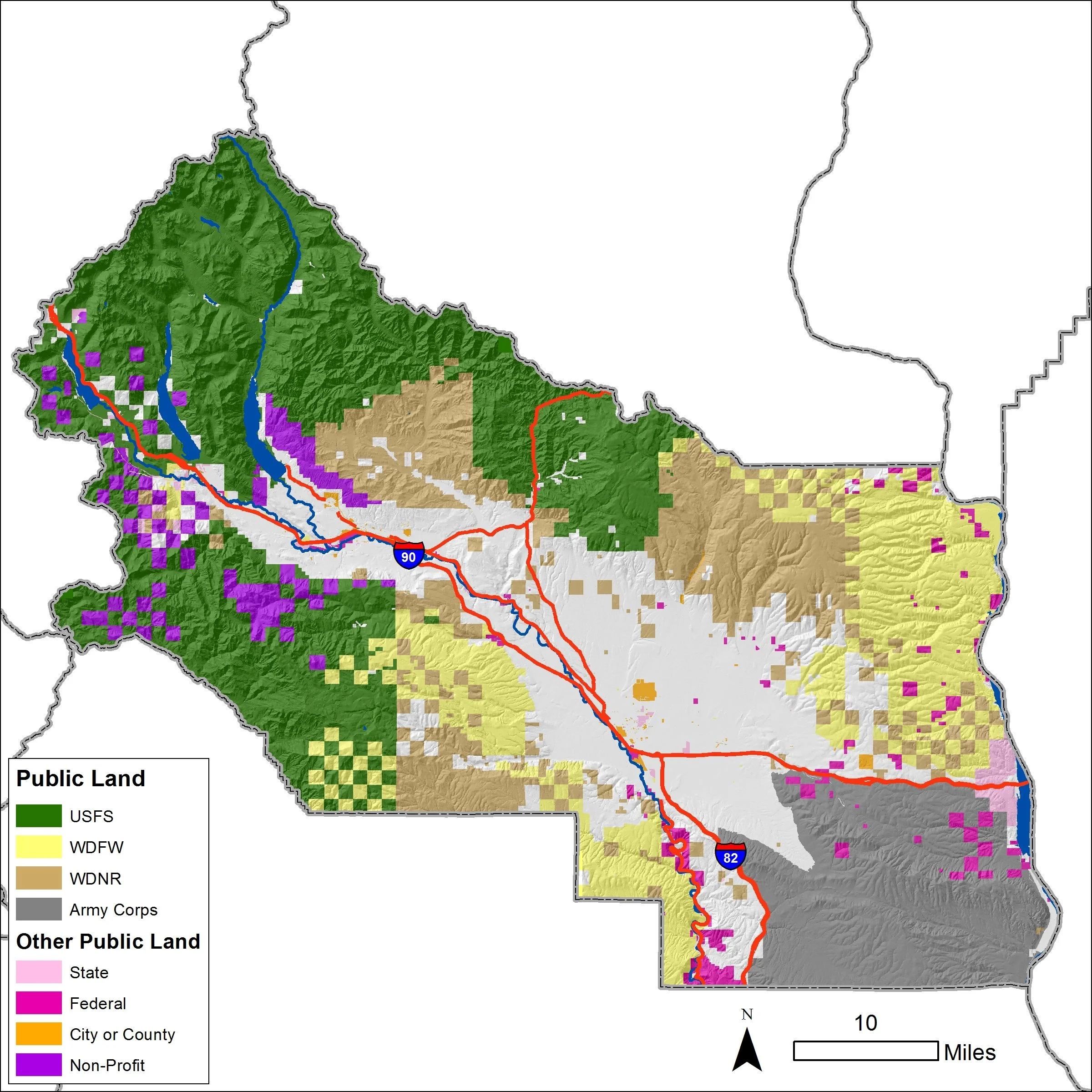
Map for the Ellensburg Daily Record illustrating a story on the expansion of Washington Department of Fish & Wildlife lands in Kittitas County, Washington.
Data Subscriptions
Use our data on your maps or studies. Start your project with the information you need with one of our affordable data subscriptions.


Partner With Us
& let your imagination soar - the sky is the limit!
If you have an idea for a print map, web map or other map product or if you would like to partner with us on the marketing of one our topic maps (camping, boating, dogs, kids, horse, hike, bike.) let us know. We can develop a join product and marketing strategy and share revenue. If you have an idea that you are ready to market, we can provide the product with no up front costs.