
Snow Northwest
Everything you need to plan your winter adventure
Your Source for Winter Adventure Destinations
Snow Northwest (Snow NW) is the Web Map and App for Apple and Android for people seeking winter adventures.
Find everything you need: trails, trail access, facilities, recreation lands and rules, and even the snow depth. Whatever your winter sport, Snow NW has you covered. Find information for:
Snowmobiling |Tracked ATVs | Nordic & Alpine Skiing | Snowshoeing | Snowboarding | Sledding | Fat Tire Biking | Dog Sledding
The maps are updated regularly with information on seasonal, temporary, and emergency closures. Navigate with your phone GPS and download Regions on the App for offline navigation.
Use filters to find the perfect recreation or business destination. Want a place that has both Nordic and snowmobile trails, or a nearby restaurant with beer on tap that is open on Sundays? Snow NW has you covered!

Free App for Apple & Android
Download Regions to navigate even when offline
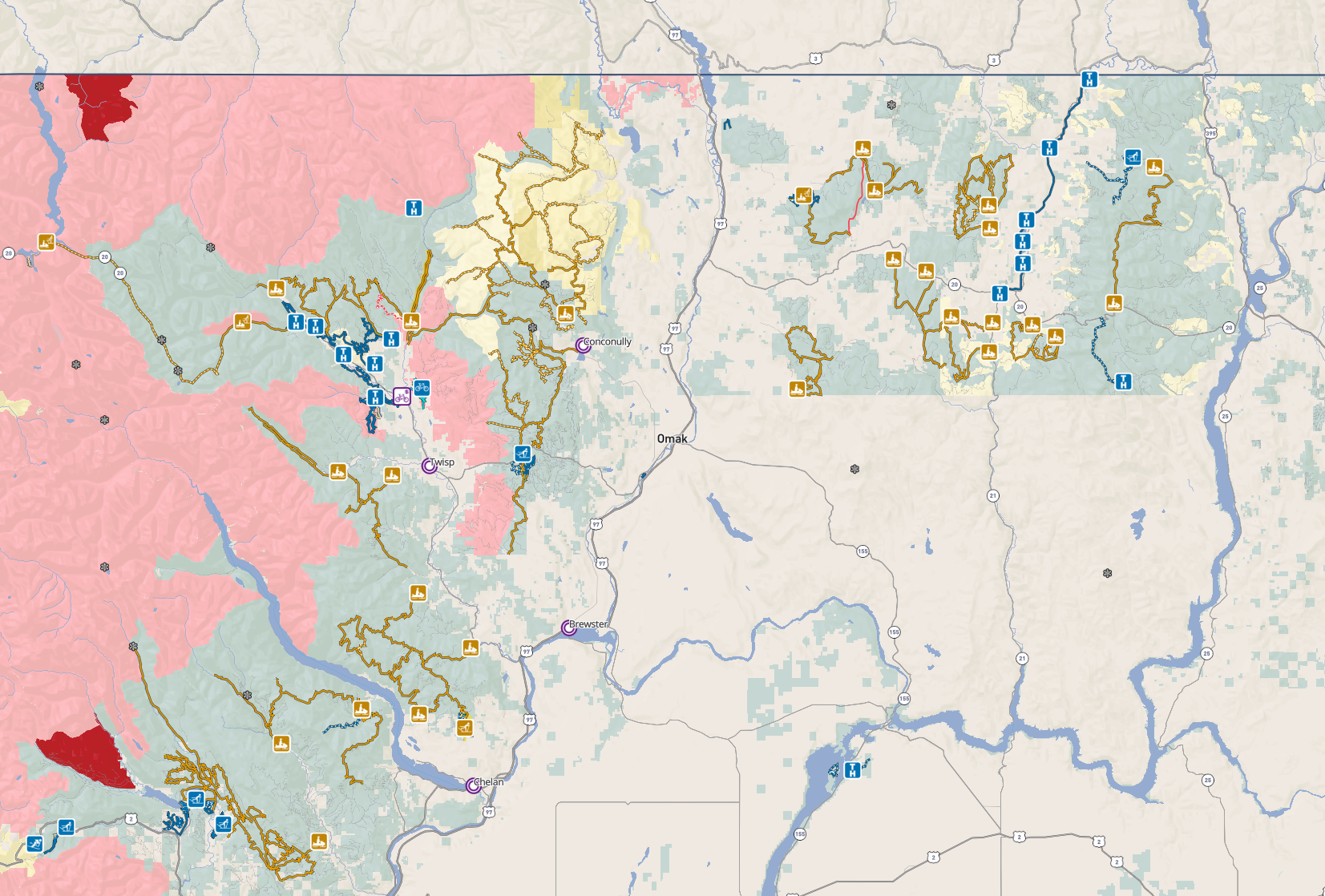
Snow Northwest Winter Recreation Map
Map Legend
Northwest Portal’s Snow NW Blog Posts


Support Snow NW
And Keep it Free For Users
The Snow NW maps and apps are a public service of Northwest Portal. We need your support to keep them free. Join one of our supporting clubs and let them know you saw it on Northwest Portal or encourage your club to becoming a supporting member (just $150/year). Stop by one of the businesses that are on the map and let them know you saw them on Northwest Portal, add your business (as low as $200/year) or let your favorite businesses know about the project. Tell your friends about the web maps and apps—the more users we have, the easier it is to get business support. Consider making a donation to help keep the apps free for users.
Winter only businesses that sign up at the essentials level will be upgraded to Premium free for more visibility.


Printable/Geo PDF Maps
The web maps and apps are great for navigating and exploring, but sometimes nothing but a print map will do.
GeoPDFs
Northwest Portal has created a set of 36”x36” GeoPDF maps designed specifically for use on Avenza covering all of the areas with groomed winter trails in Washington State. These nine maps are at a scale of 1:55,00 to 1:140,000 and each map covers a contiguous riding area. These maps are available from the Avenza store for $3.99 or as a bundle $16.99. You can also find 18x24” maps of areas where we have supporting businesses or clubs at a scale of 1:120,000-1:235,000 of selected riding areas for sale for $2.99 on the Avenza store or as free downloads (below). The maps are available from the Avenza store: 36x36” maps are $3.99 each or $16.99 for a bundle of all nine maps and 18x24” maps are $2.99 each or $9.99 for a bundle of all seven maps.
Printable/Geo PDF maps
As a thank you to the businesses and clubs that support us, we have published a set of printable/GeoPDF maps for every area with a supporting club, business or community. The map sets include two sided letter and tabloid sized maps and 18x24” posters with and without contours. The posters are in a GeoPDF format and can be printed or used on a mobile device with a GeoPDF program like Avenza.
Printed maps
Get laminated printed versions of the Kittitas-Yakima and Ahtanum maps at Gold Creek Station on Hwy 410 above Naches and at the Hitching Post in Easton off of I-90. If you would like to carry custom versions of these maps, contact us for more information.
You can add your club to the maps for just $150 (and get custom maps of your riding areas.) Business plans start at just $200 to be on the winter map web map, app and print maps or $300 to be on all of the apps and maps in the Northwest Portal set. Businesses can request a version of the map with their icon on the business location.


Printable maps are available for the following areas:
Republic area of Okanogan County (36x36 GeoPDF on Avenza only)
Southeast Washington: Umatilla National Forest (36x36 GeoPDF on Avenza only)
Central Cascades: Kittitas and Yakima Counties
Available free thanks to our club sponsors: Cascade Drift Skippers, Sno-Jammers and Junco Snowmoible Club local business supporters I-90 Motorsports, Apple State Power Sports, Central Powersports, Gold Creek Station, The Hitching Post and Motor Toys Rental and Tours, and project sponsors Premier Polaris and Lake Chelan Chamber of Commerce.


Two page map of the trails in Ahtanum State Forest, Letter only

18x24” GeoPDF Posters
Download or use on your phone with Avenza
All of Kittitas & Yakima Counties

Kittitas & Yakima Counties with contours

Crystal Springs to Greenwater

Crystal Springs to Greenwater with contours
Chelan County
Available free thanks to our project sponsors Premier Polaris and Lake Chelan Chamber of Commerce.


Trails on both sides of Blewett Pass: Lily Lake-Kittitas County and Chelan County: Tabloid only

18x24” GeoPDF Posters
Download or use on your phone with Avenza
Chelan County

Chelan County with contours
Get the map on Avenza: 18x24” Map of Chelan County 1:176,000, 36x36” Map of Lake Wenatchee and trails west of Lake Chelan at 1:60,000 and 36x36” Map of trails on both sides of Lake Chelan at 1:55,000.
Northwest Cascades
Available free thanks to our project sponsors Premier Polaris and Lake Chelan Chamber of Commerce.

18x24” GeoPDF Posters
Download or use on your phone with Avenza

NW Cascades

NW Cascades with contours
Get the map on Avenza: 18x24” map of the Nothwest Cascades at 1:156,000 and 36x36” map of the Northwest Cascades at 1:100,000.
North Central Cascades
Available free thanks to our club sponsors: North Central ATV Club, local business supporters Three Finger Jack’s and Snowmobile Winthrop and project sponsors Premier Polaris and Lake Chelan Chamber of Commerce.


Letter sized map of trails in the Winthrop Area.
18x24” GeoPDF Posters
Download or use on your phone with Avenza

North Central Washington

North Central Washington with contours
Pend Oreille County (NE Washington) and Priest Lake Idaho
Available free thanks to our club sponsors: Spokane Winter Knights and project sponsors Premier Polaris and Lake Chelan Chamber of Commerce.

18x24” GeoPDF Posters
Download or use on your phone with Avenza

Pend Oreille-Priest Lake

Pend Oreille-Priest Lake with contours
Get the map on Avenza: 18x24” map of Pend Oreille to Priest Lake at 1:200,000 and 36x36” map of Pend Oreille to Priest Lake at 1:100,000.
Southwest Cascades - Gifford Pincho National Forest
Available free thanks to our club sponsors: Junco Snowmoible Club and project sponsors Premier Polaris and Lake Chelan Chamber of Commerce.
18x24” GeoPDF Posters
Download or use on your phone with Avenza


NW Cascades with contours
Get the map on Avenza: 18x24” map of SW Washington/Gifford Pinchot at 1:180,000 and 36x36” map of SW Washington/Gifford Pinchot at 1:125,000.


Charity on the Snow Route Map
Download GeoPDF/Printable basic map or map with contours

Gathering good Snow Recreation information is challenging. We work with users, organizations, and area managers to tell the story of winter recreation in Washington.
When using the app for Apple or Android you can download any of these 18 regions free for off-line navigation.
Snow Northwest (Snow NW) is now available as an App for Apple or Android thanks to the generous support of our Sponsors, Club Supporters, and participating Businesses. When you visit them, please thank them for their support of this project.
Sponsors
The Snow NW App is entirely free to users - thanks to these supporting Sponsors, Clubs, and Advertisers


Participating Communities
Brewster, Lewis County, Travel Tacoma, Walla Walla Downtown, Wilkeson
Participating Clubs
Cascade Drift Skippers, Sno-Jammers, North Central ATV Club, Junco Snowmoible Club, Spokane Winter Knights
Participating Businesses
I-90 Motorsports, Apple State Power Sports, Central Powersports, Gold Creek Station, The Hitching Post, Motor Toys Rental and Tours, Premier Polaris, Seabrook Resort, Selkirk Sun, Stoneridge Resort, Snowmobile Winthrop, Three Finger Jack’s, Vancours Powersports, Wenatchee Powersports, Wolfpack Powersports
If you dream of riding through a winter wonderland in Washington’s Cascade mountains or want to trying snowmobiling before you invest in the equipment, treat yourself to a guided snowmobile tour or, if you have some experience, rent a snowmobile and explore on your own. Snowmobile Winthrop and Motor Toys Rental and Tours in Cle Elum will help you get out on the snow.