
Unprecedented detail: how high-res satellite imagery is transforming modern cartography
Satellite Imagery
The mapping of our planet is, aside from food and shelter, one of the oldest human endeavours. Originally, cartographers represented only the region or country where they were located, using basic objects and views from the highest points in their area. Over time, they began representing larger areas, sometimes informed by reports from sailors or soldiers who travelled far. For much of the 20th century, aerial photography from airplanes was the key tool for mapping, weather permitting.
Fortunately, over the past several decades, this process has become much faster and more effective. This shift began with the revolutionary advent of satellites, which capture vast areas of land. As image quality improved, it became easier to distinguish small objects—such as large trees or vehicles. Today, high-resolution satellite photos for mapping enables maps with a level of detail never seen before.
A New Era of Precision
The process of improving satellites has been ongoing since the first satellites, back in the 1970s, were available only to the military. Unlike those early images, which had fairly low resolution, today's high-quality satellite images have a resolution of less than one metre (meaning each pixel on the screen is one metre in real life), providing a level of clarity that was unimaginable just a few years ago. There is already a new category of satellite imagery, called very high resolution satellite imagery, with a resolution ranging from 16 to 49 cm, and in the near future, ultra high resolution satellite imagery will be widely available, with a resolution of less than 15 cm.
Beyond image quality, another substantial difference between modern cartography and older systems that relied on periodic flights lies in the ability to bring information on a regular basis. Satellites provide frequent updates, allowing any changes in the landscape to be monitored in near real time. From coastal erosion to agricultural activity in a region, urban sprawl tracking to infrastructure monitoring, access to hi-res satellite images has not only improved cartography in general but has also significantly accelerated data-driven decision-making.
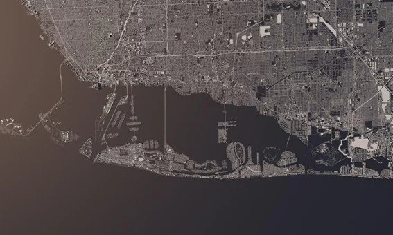
Urban Inequity, Seen from Space
Urban expansion is often cited as one of the most common phenomena of recent times, as many cities around the world need to grow to accommodate people who move there. However, another phenomenon associated with urbanisation sometimes goes unnoticed: inequality between neighbourhoods, cities, or even regions. Although statistical data can be used to determine these inequalities (for example, by comparing average incomes across two or more places), satellites also offer a unique perspective on how citizens in the same region lack access to the same services.
Aspects such as the amount and greenness of vegetation, the condition of pavements and roads, the availability of sufficient public transport option or services are examples of how noticeable inequalities persist even in areas separated by just a few dozen metres. Hotter summers, poorer connections for commuting to work, or longer journeys to access basic services mean a poorer quality of life for some citizens compared to others.
Environmental Monitoring at Scale
Climate change and its undesirable effects underscore the need for environmental care and sustainability. High-resolution multispectral satellite imagery, capturing data across several wavelengths beyond visible light, helps ensure regulatory compliance and supports sectors adapting to these demands:
● Deforestation in the Amazon and other vulnerable forests can be monitored and accounted for tree by tree.
● The degradation of wetlands and marshes can be monitored seasonally.
● Glacier recession can be documented year by year.
● Coastal erosion can be measured by comparing the recession in centimetres over time.
With this spatial data, scientists and policymakers can quantify damage and evaluate conservation policies. Instead of relying solely on occasional samples, they use current satellite data for more accurate conclusions.
Advancing Scientific Research
Universities and scientific institutions have found high-resolution Earth images to be a reliable, extensive, and powerful source of data for a wide range of studies. For example, climate scientists can model soil carbon storage by region; public health researchers can study environmental risk factors associated with urban density; and geographers can analyse spatial patterns of land-use change.
The integration of diverse technologies, such as artificial intelligence and machine learning, expands these possibilities. Algorithms based on these technologies automatically detect numerous parameters, drastically reducing manual analysis time.
What does the future hold?
Satellite constellations are already reducing revisit times from weeks to hours and in just a few years, resolution has improved several times over. New sensors and additional technologies that facilitate data analysis are some of the latest developments in this field. We can expect technology to continue evolving, improving current capabilities, and creating new ones.
Yet, cartography remains a human pursuit. It's not just about mapping, but understanding changes, their reasons, and their effects on life.