

Custom Maps
Tell your story with custom print or interactive maps.

Affordable maps for your area or event!
Our Washington State recreation data and map template lets us quickly create custom maps that tell your story. You pick the size, area and topic, title and add your logo for our base price. Upgrade to add your businesses, routes or customize any aspect of the map, or to pair the print map with a custom web map.
Northwest Portal has the most comprehensive data set of recreation in Washington State with information on all types of recreation managers, from federal and state agencies to local communities, non-profits and more. Our information on over 20,000 recreation opportunities is carefully managed to minimize errors and show the latest information as recreation opportunities change, and it includes information like recreation passes and facilities that help people find the perfect destination.
Our core data set has summer recreation in Washington State and winter recreation in Washington, Idaho and Oregon.
Want a map of a different area, or a non-recreation topic, we can create fully custom maps for any topic or area.

Custom Recreation Maps
Starting at $300
Pick from outdoors, off-roading, winter, biking or boating basemap. Customize with area, logos and more.
Pick the size, area, features to highlight. Add your logos and text. Add a back side for just $100.
Customize colors, font style and size, add businesses/locations or tour routes, include photos and tables or pair with an interactive map for an additional fee.
Highway 31 Yard Sale for Innovate Ione: Print & Web map

Multi-Page maps customized with tables & business details
Conconully Summer & Winter Recreation: Two sided map. Client sold advertising and sold print map.
Two page promotional winter map of the Lake Chelan area with supporting businesses and details on the Sno-Parks
Map Set for the Omak Chronicles Annual ORV Guide
Once the initial design was approved, updates area made annually where there were changes in road or trail access.

Prices & Products
There is no charge to add public recreation resources to our recreation maps or data set. If you know of recreation areas, facilities or trails that are not on our maps, contact us and we will get them added.
Print Maps
Base price $300 for a one page map or $400 for a two page map. Additional maps ordered the same year and updates are 50% off.
Price includes the following:
Pick a topic: outdoors (all sports), trail sports, biking, off-roading, dogs, boating or winter sports.
Select a size: letter, tabloid or poster, or custom.
Identify the area that you want shown on the map.
Choose
Contour lines on or off,
Which types of features to label and if you want labels to include elevation,
How to symbolize roads and trails: by individual sports, two classes (non-motorized or motorized), or all the same color.
Add your logo, name and custom text.
Choose the output format: pdf (GeoPDF), jpg, png, tiff or .ai.
Up to three revisions.
Interactive maps that can be accessed through a browser
Interactive maps allow users to scroll, zoom in, get more information and use search and filters to highlight specific places. Interactive maps can be paired with print maps or produced independently. Maps use the Northwest Portal recreation data set as the base - this data is updated at least 2x/month to reflect seasonal and temporary closures, plus new or changed facilities.
Map configuration/first year.
Configure the map and first year hosting: $600,
Additional maps for the same client 50% off.
Additional years and updates:
Web map hosting (with the latest recreation data): $250/year,
Data updates (for custom layers created for the project): $40.
Additional maps for the same client 50% off the initial and subscription fees.
Upgrades to print and web maps
Fee is only charged once even if the upgrade is applied to multiple maps. Upgrades can apply to both print and web maps.
Add your businesses or event locations to the print or web maps. Businesses can be added or managed by the client or by Northwest Portal.
Through a spreadsheet or google doc. There is no charge to add custom points to a print map if the client provides a spreadsheet with everything need for the map, including location (Lattitude and Longitude), and anything for a label or information table (name, type, etc.).
If the spreadsheet has the information that is needed to add it to a print or web map, including name, coordinates (lat/long) and business type, there is no charge to add it to print maps.
The businesses can be added to a custom web map as a custom layer for $75 plus $30 to update from the same sheet.
Northwest portal can create the spreadsheet or fill out fields (such as lat/long) for $35/hour.
Add business to the Northwest Portal database.
Northwest Portal will create a record for each business, update information annually, and allow businesses to send updates for their information that will incorporated in the bi-monthly data updates.
Businesses that are in the Northwest Portal database Northwest Portal database will be added to the public web maps and will be available for custom web or print maps. Northwest Portal will create a record for each business, update information annually, and allow businesses to send updates for their information that will incorporated in the bi-monthly data updates.
The cost to add a business is $25/location, plus $10/year to update the business and keep it on the web map after the first year. There is no charge, even after the first year, to keep the business in the database for print maps.
Discounts are available.
Add a route or loop: $40 to map the route, $20 to update. There is no charge to add trails or recreation facilities that are open to the general public.
Customize map design including colors, fonts, icon style and custom layers: $80/hour.
Fully Custom maps
Maps to tell any story. Billed at $80/hour rate. Nothwest Portal can provide a guaranteed rate or a not-to-exceed cap depending on task.
Maps for studies,
Legal documents,
Real-estate listings,
To illustrate articles, books or lectures.
More Maps
Northwest Portal can create custom maps to illustrate any story: property maps for realtors, maps to illustrate a news article or book, history maps, geology maps, and more.

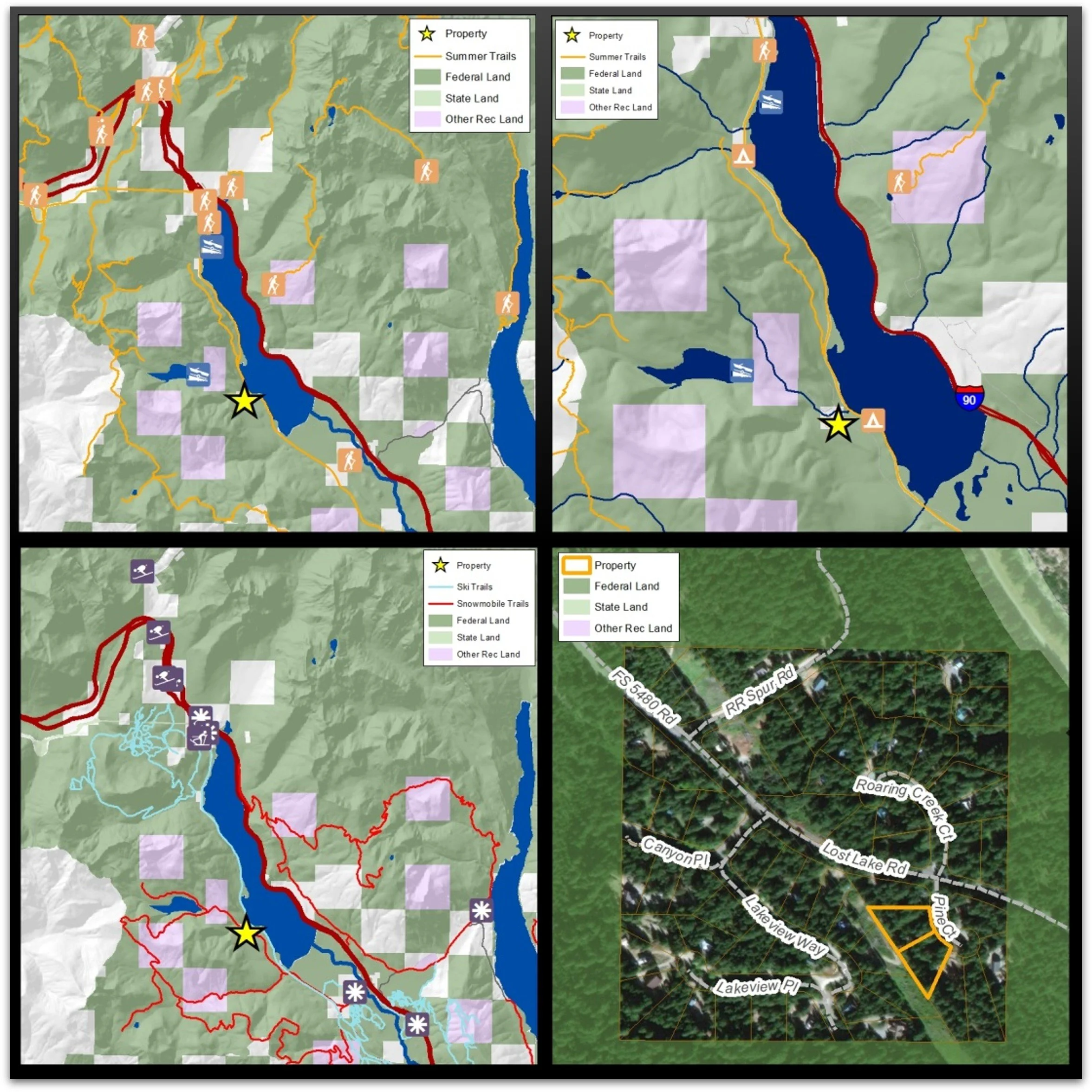
Maps for realtors
Show what makes a property special or help clients connect the places they are seeing with the things that are important to them.

Study Maps
Grant County Tourism Study: 30 maps on different topics with an interactive map that allows users to navigate information on each map.
Access all of the maps from the study page.

Wildfire Maps
Updated daily during the wildfire season. Posted to a fire page, shared on social media, and available for publication.
Maps to illustrate articles, books or lectures

Map for a series of lectures on basalt flows in the Pacific Northwest.
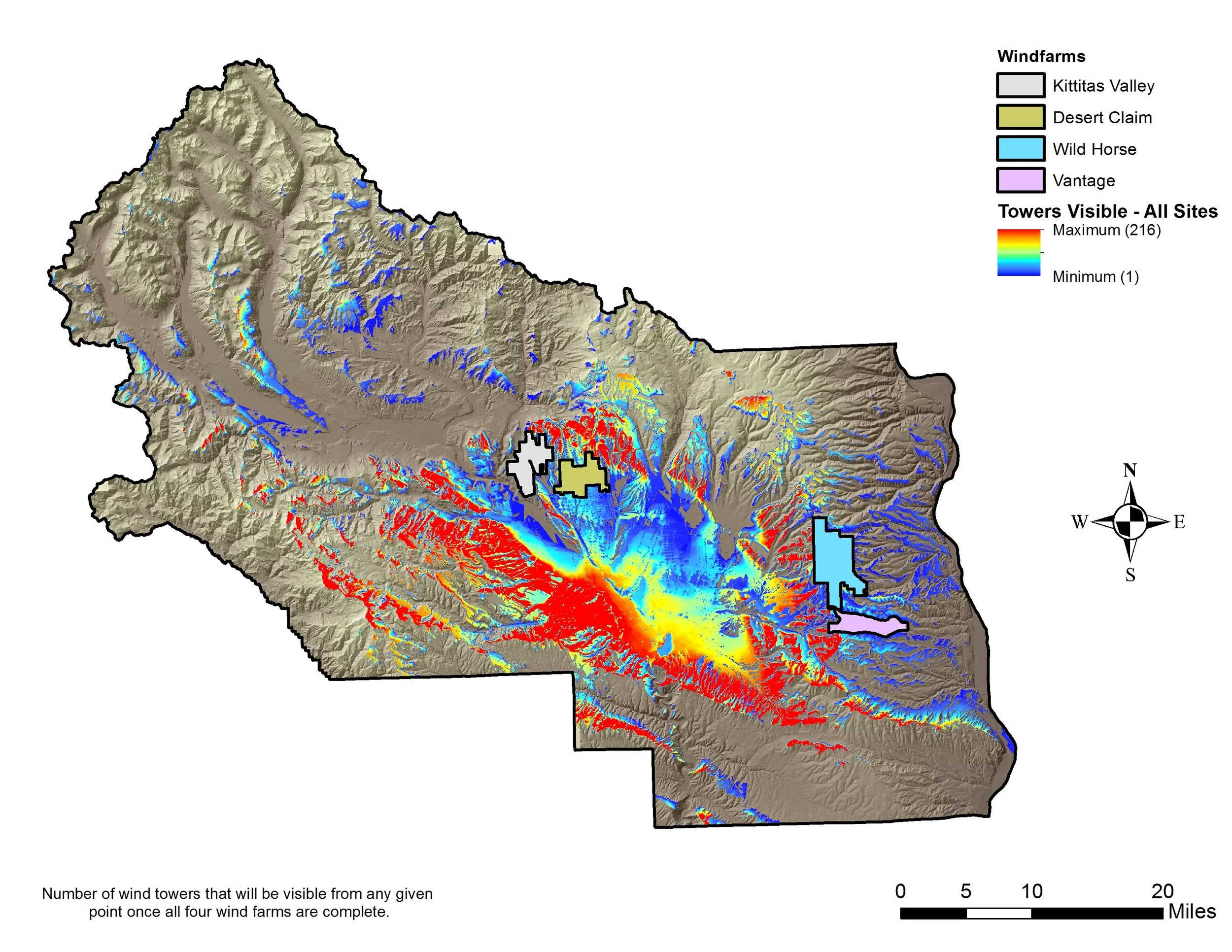
Map for a newspaper article on visual impact of proposed windfarms

Request a map
Email a description of the map or maps, or fill out the form below. We will reach out to you to confirm details before sending a draft map for approval.