
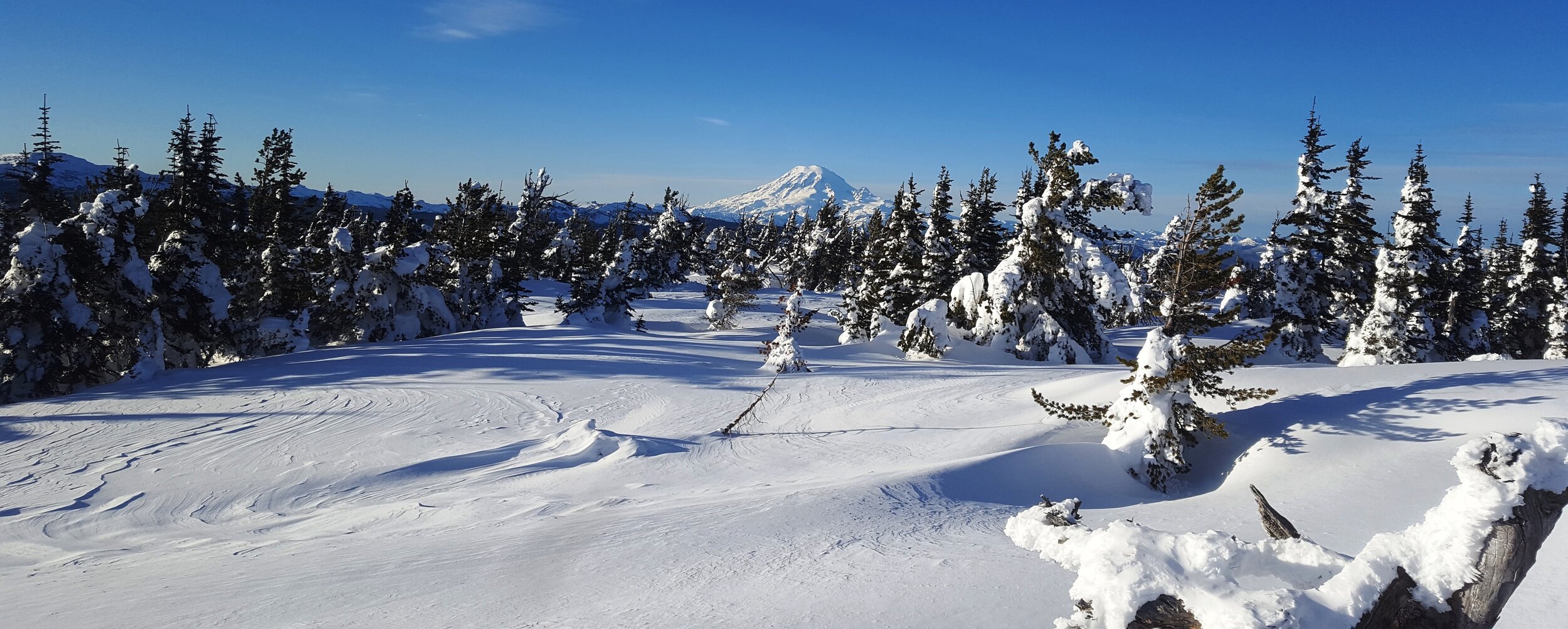
Snow Northwest
Discover your next winter adventure in Washington, Idaho & Oregon.
Snow NW
Your source for all of the information you need to plan and navigate your next winter adventure. Snowmobile, Nordic and Fat Bike trails in Washington, Idaho and Oregon.
Use the web map that you can access from any browser or buy a GeoPDF map that you can print or use to navigate off-line.
More than 15,000 miles of winter trails and 400+ trailheads, Sno-Parks, and winter recreation facilities in Washington, Idaho, and Oregon. Snowmobiling | Tracked ATVs | Nordic & Alpine Skiing | Snowshoeing | Snowboarding | Sledding | Fat Tire Biking | Dog Sledding
Printable/GeoPDF maps
Download maps to print, view in your browser or use with a GeoPDF reader such as Avenza Maps.
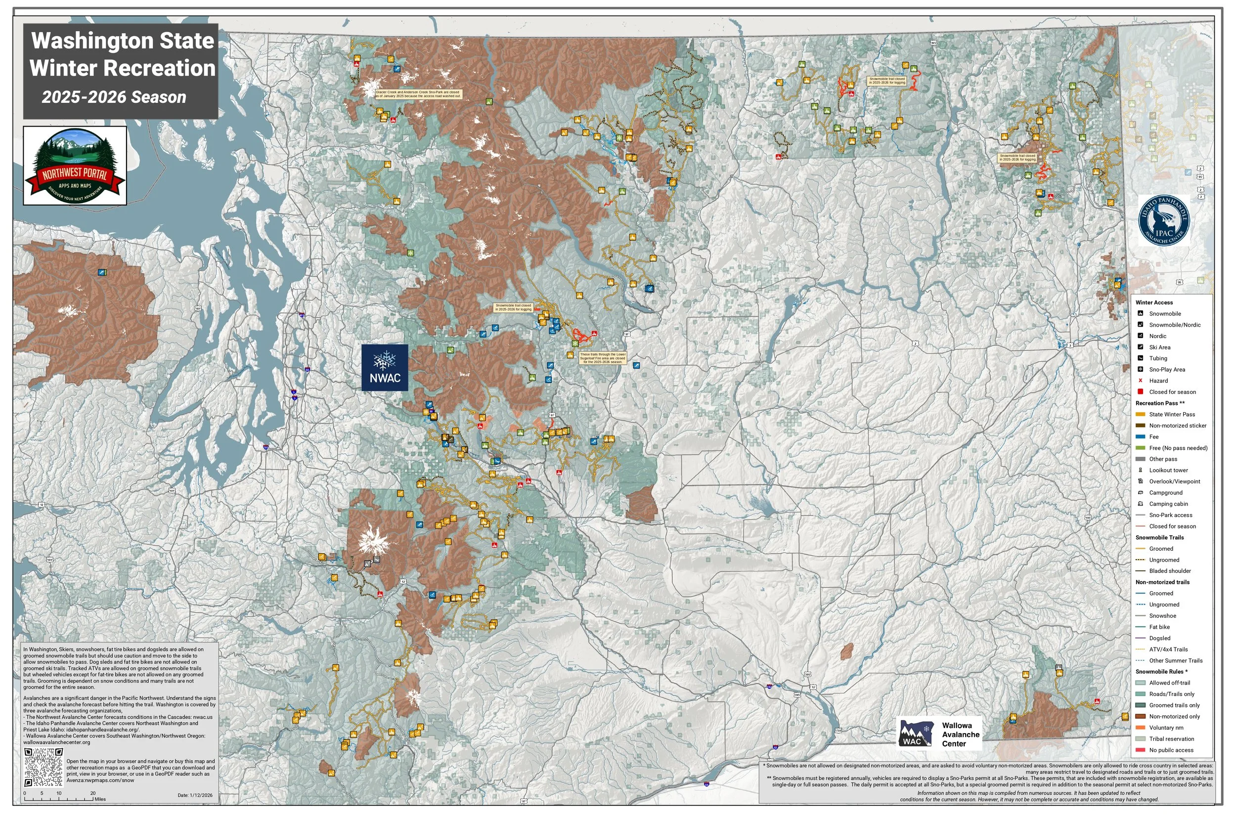
Northwest Portal has created a set of maps covering all groomed snowmobile trails in Washington State and will be adding maps of Nordic areas and selected snowmobile trails in Oregon and Idaho. The maps are updated for the 2025-2026 season, including temporary closures and changes to groomed routes.
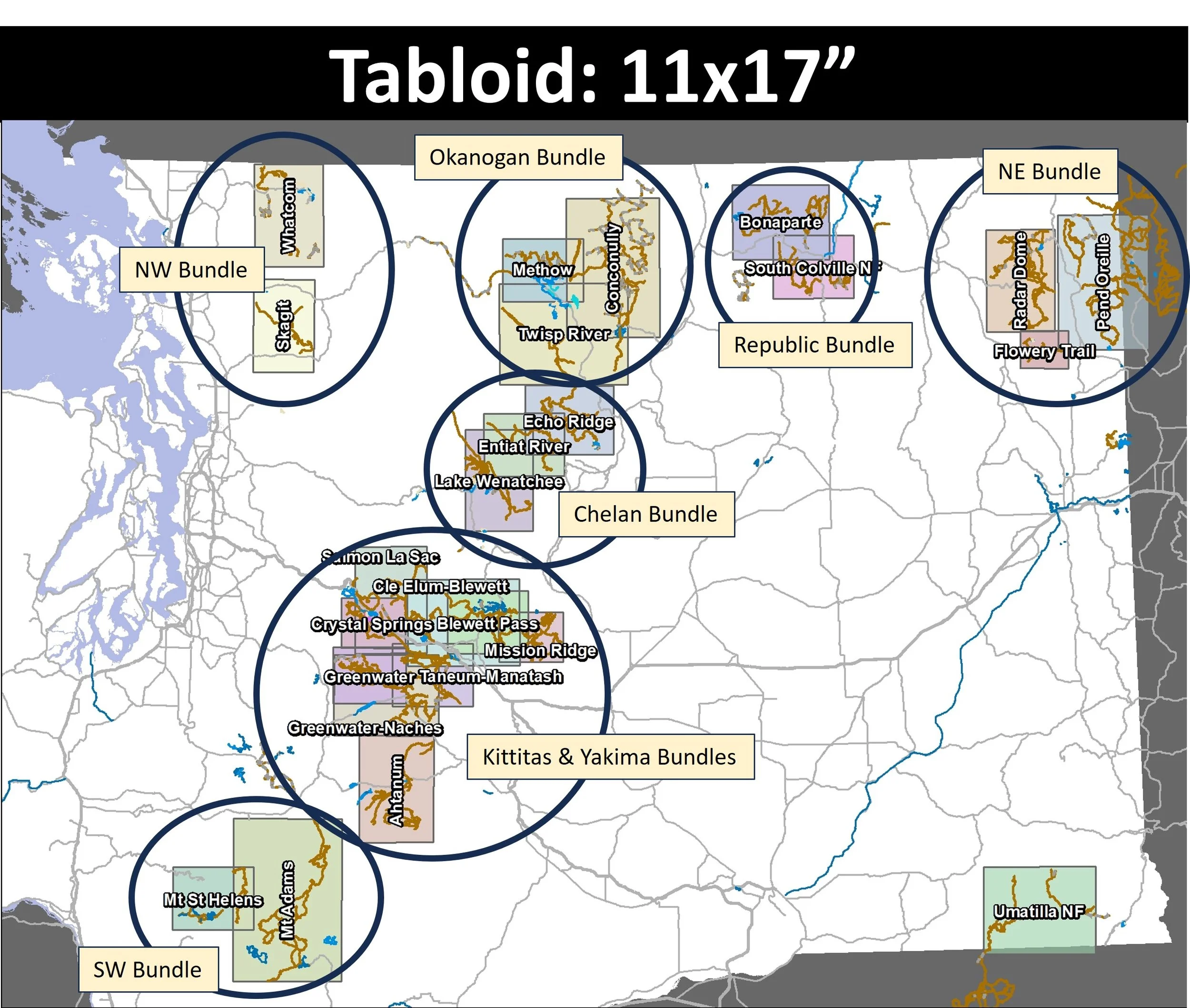
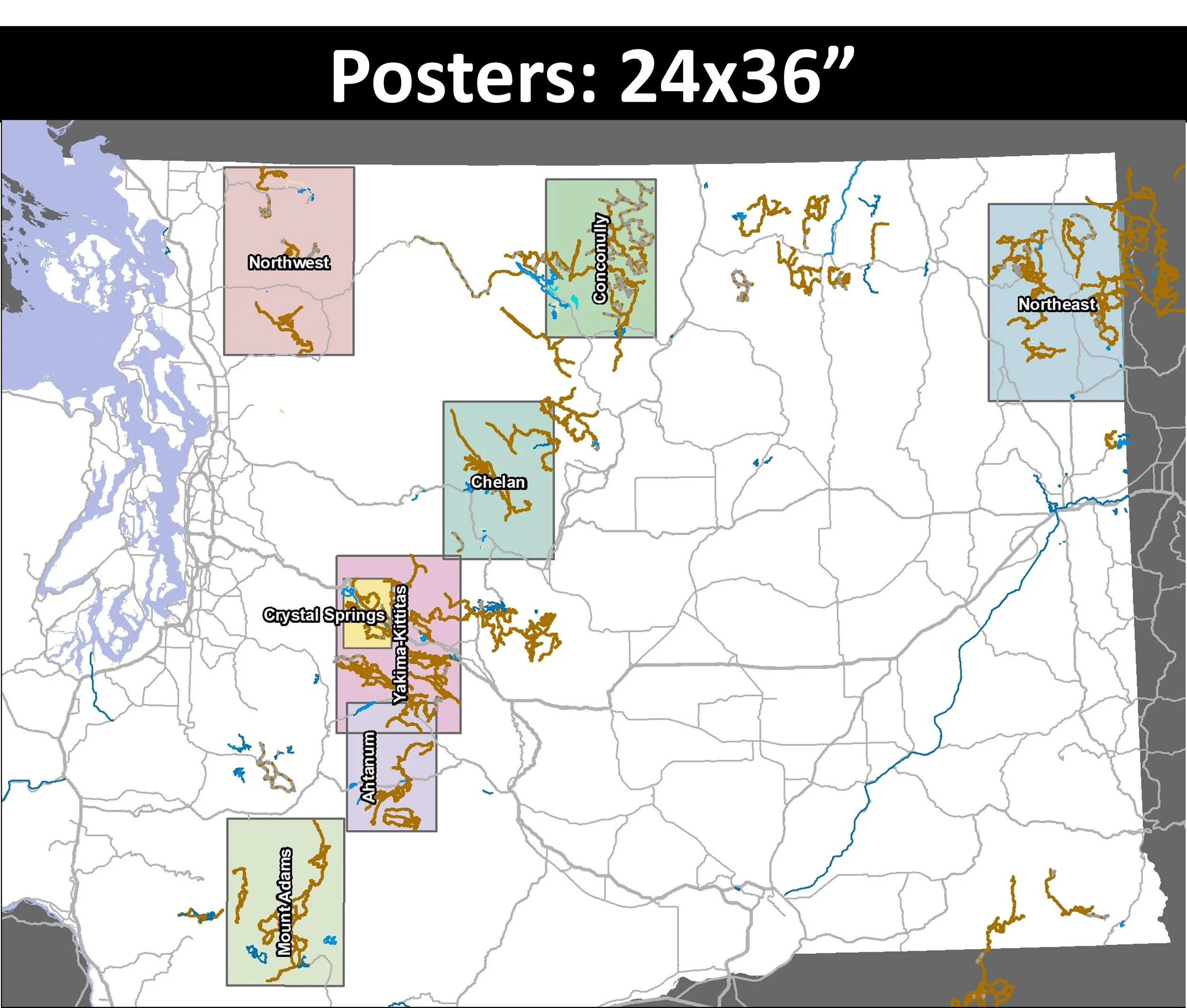
Maps purchased from the Northwest Portal store are available in both tabloid (11x17”) and poster (24x36”). Tabloid maps include two versions of the map, one with contour lines and one without. All poster sized maps have contours. The maps can downloaded and opened with any PDF reader, printed, or used with a GeoPDF reader such as Avenza. The maps have all groomed snowmobile trails, un-groomed routes identified by local snowmobile clubs, Nordic trails, snowshoe routes, recreation roads and summer trails as those are often used for winter recreation. Recreation lands are symbolized to show the rules are for snowmobiles (allowed off trail, on road or trail only, and no-motorized use) and trail access shows which recreation pass is required for parking. The maps also have campgrounds, view points, fire towers and state parks. They are designed to capture complete riding areas (where possible)
The poster sized maps with contour lines can also be purchased on the Northwest Portal Store on Avenza Maps. Map purchased directly from Avenza do not count against your Avenza map limit, but can only be used in Avenza.
Want a different area: Use the CONTACT US form to tell us what are you want and we will send you a link once the map is in the store.
Washington State
Overview Map - Download Free
GeoPDFs
Washington Tabloid and Poster sized maps and bundles for Sale
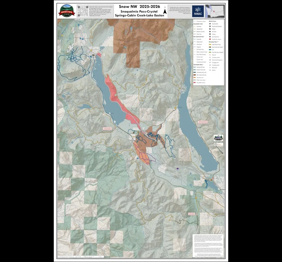
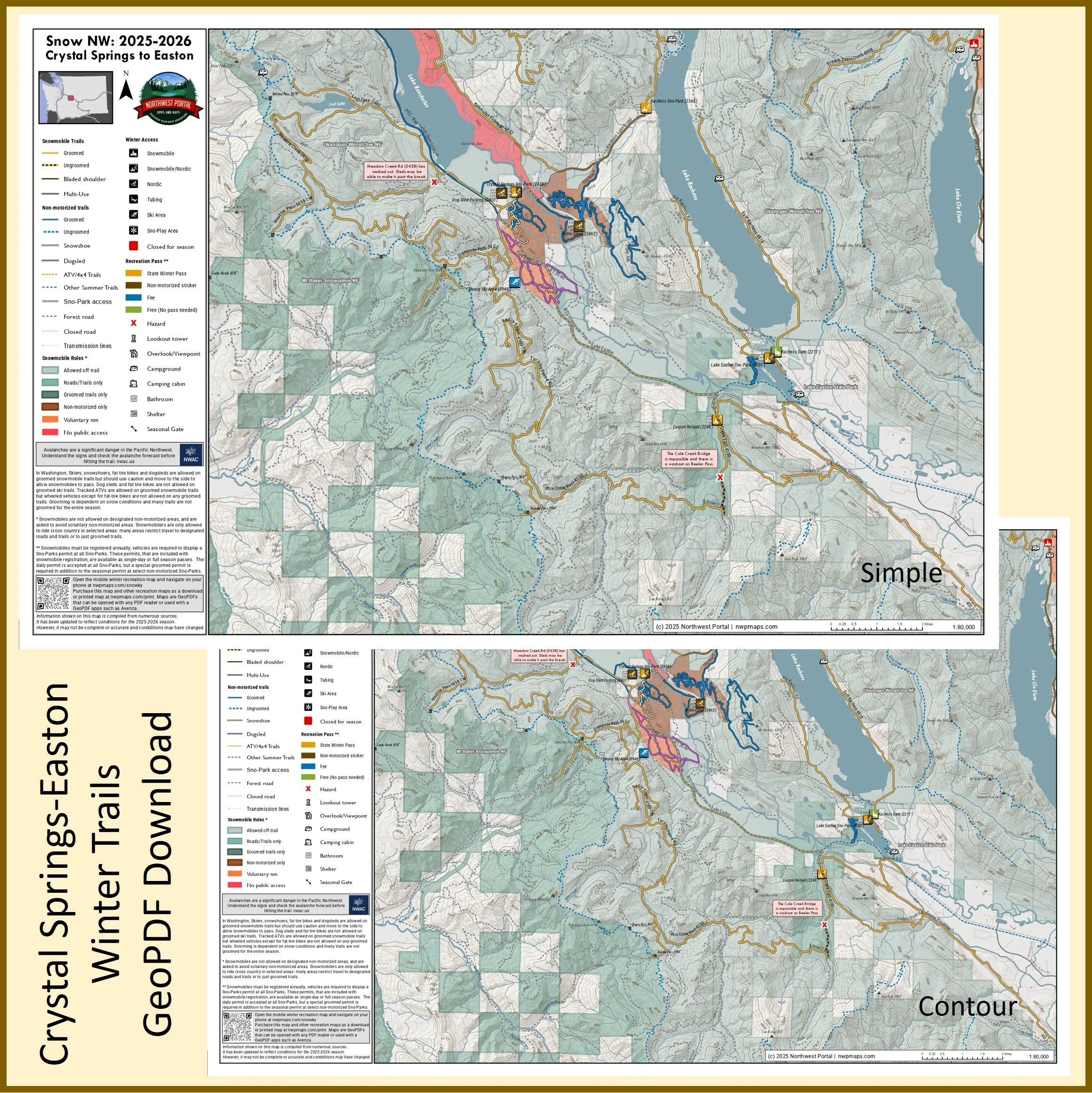
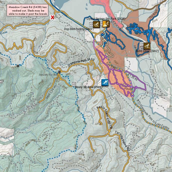
This map of winter trails in the Snoqualmie Pass/Crystal Springs area of upper Kittitas County, Washington is part of a series of winter recreation map that show where you can ride your sled, ski, dogsled or snowshoe in the Pacific Northwest. See which trails are groomed, what areas snowmobiles are allowed and where they are restricted. The maps, which were updated for the 2025-2026 season, include shelters, campgrounds, viewpoints, fire towers as well as summer trails and recreation roads, that are often utilized for winter recreation, campgrounds. The map is a poster sized sized (24x36”) GeoPDF at a 1:35,000 scale that you can print or use with a GeoPDF app such as Avenza. The map includes trails out of the Crystal Springs, Hyak, Cabin Creek, Lake Easton, Easton Reload, and Kachess Sno-Parks and trailheads. The map also shows the Snoqualmie Nordic Center trails.
Kittitas County Washington
Crystal Springs, Manastash-Taneum, Salmon La Sac, Blewett Pass, Mission Ridge
Poster Sized Maps: 24x36”
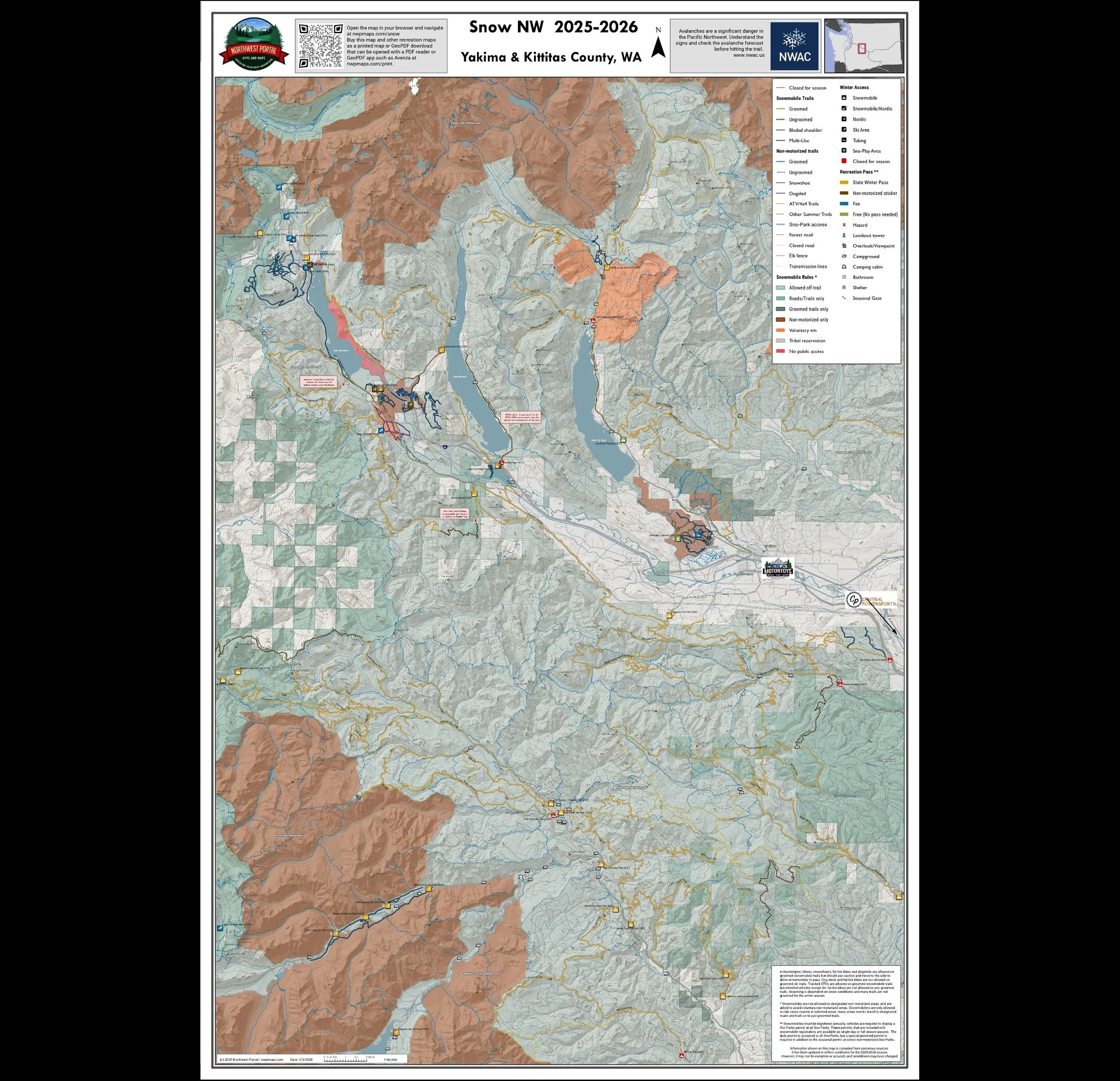
This map shows the connected groomed snowmobile trail system from Crystal Springs near Snoqualmie Pass in Kittitas County to Greenwater at the top of the Naches watershed in Yakima County. It also includes the Salmon La Sac trail system, trails between lake Kachees and Lake Cle Elum and the Teanaway Community Forest. For Nordic skiers, snowshoers and dogsledders it includes the Snoqualmie Nordic Center, Crystal Springs/Cabin Creek Trails, Suncadia trails and Hells Crossing Nordic Trails. It is part of a series of winter recreation map that show where you can ride your sled, ski or snowshoe in the Pacific Northwest. See which trails are groomed, what areas snowmobiles are allowed and where they are restricted. The maps, which were updated for the 2025-2026 season, include shelters, campgrounds, viewpoints, fire towers as well as summer trails and recreation roads, that are often utilized for winter recreation, campgrounds. It is a poster sized sized (24x36”) GeoPDF at a 1:90,000 scale that you can print, view in your browser or use with a GeoPDF app such as Avenza.
Tabloid Size Maps: 11x17”
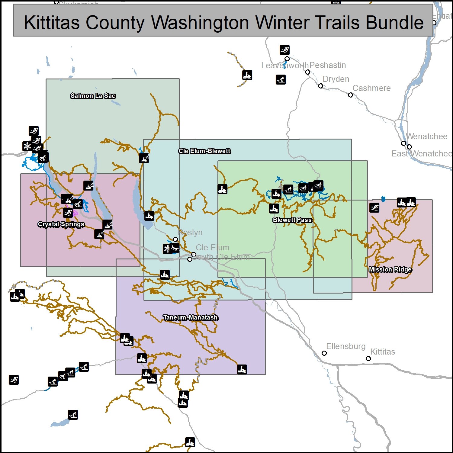
This bundle includes six maps of winter trails in Kittitas County, Washington: Crystal Springs (1:80,000), Kachess-Salmon La Sac (1:115,000), Lake Cle Elum-Blewett Pass (1:140,000), Blewett Pass (1:100,000), Mission Ridge (1:90,000) and Taneum-Manastash (1:100,000).. It is part of a series of winter recreation map that show where you can ride your sled, ski or snowshoe in the Pacific Northwest. See which trails are groomed, what areas snowmobiles are allowed and where they are restricted. The maps, which were updated for the 2025-2026 season, include shelters, campgrounds, viewpoints, fire towers as well as summer trails and recreation roads, that are often utilized for winter recreation, campgrounds. The maps are tabloid sized (11x17”) PDFs that you can print or use with a GeoPDF app such as Avenza. You will receive two versions of each map, one with contour lines and one without.

This map of winter trails in the Crystal Springs area of upper Kittitas County, Washington is part of a series of winter recreation map that show where you can ride your sled, ski or snowshoe in the Pacific Northwest. See which trails are groomed, what areas snowmobiles are allowed and where they are restricted. The maps, which were updated for the 2025-2026 season, include shelters, campgrounds, viewpoints, fire towers as well as summer trails and recreation roads, that are often utilized for winter recreation, campgrounds. The map is a tabloid sized (11x17”) PDF at a 1:80,000 scale that you can print or use with a GeoPDF app such as Avenza. You will receive two versions of the map, one with contour lines and one without. The map includes trails out of the Crystal Springs, Lake Easton, Easton Reload, and Kachess Sno-Parks and trailheads.
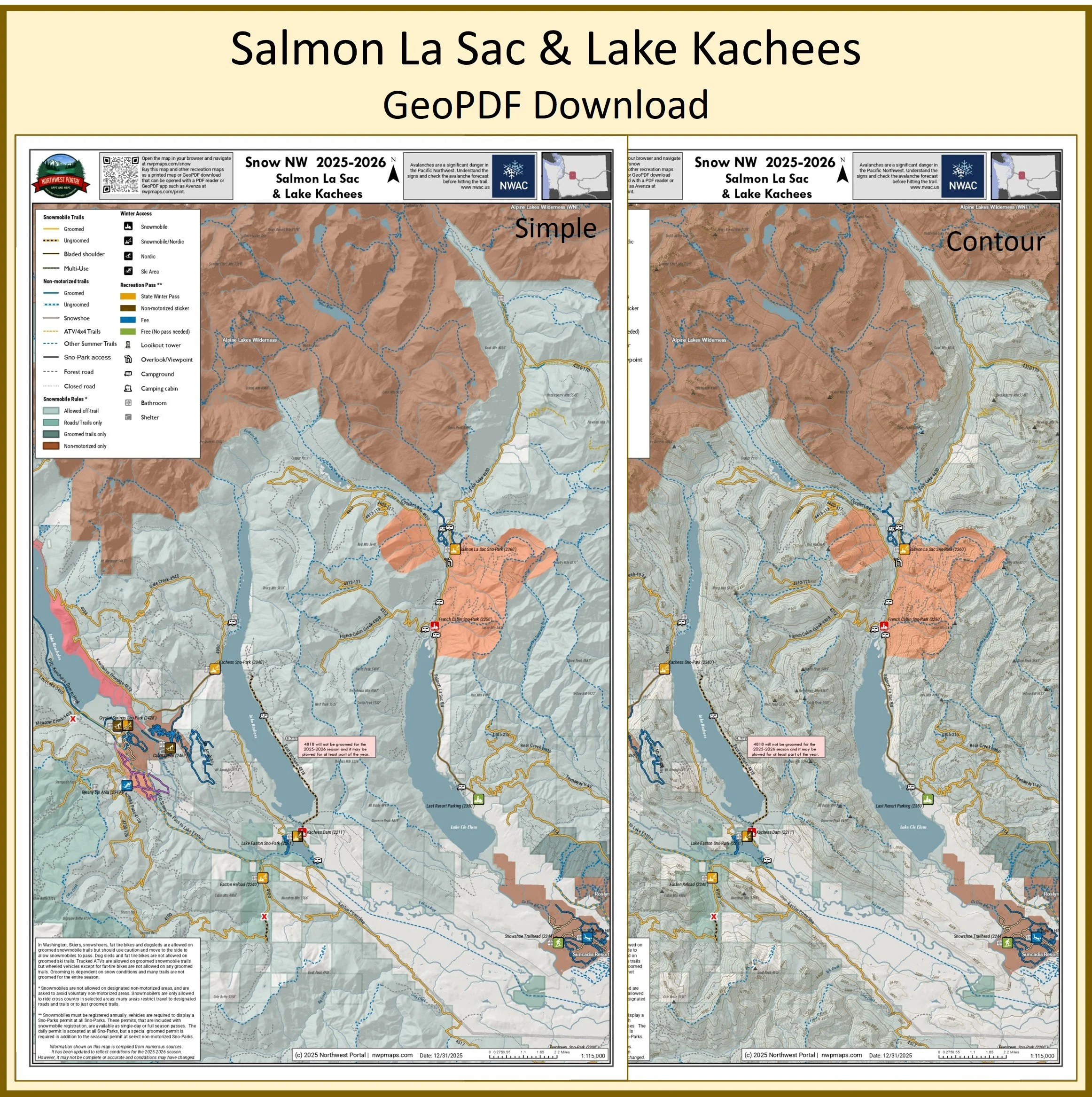
This map of winter trails in Northwest Kittitas County, Washington is part of a series of winter recreation map that show where you can ride your sled, ski or snowshoe in the Pacific Northwest. See which trails are groomed, what areas snowmobiles are allowed and where they are restricted. The maps, which were updated for the 2025-2026 season, include shelters, campgrounds, viewpoints, fire towers as well as summer trails and recreation roads, that are often utilized for winter recreation, campgrounds. The map is a tabloid sized (11x17”) PDF at a 1:150,000 scale that you can print or use with a GeoPDF app such as Avenza. You will receive two versions of the map, one with contour lines and one without. The map includes trails and trailhead between Lake Kachees and Lake Cle Elum and the Salmon La Sac Area
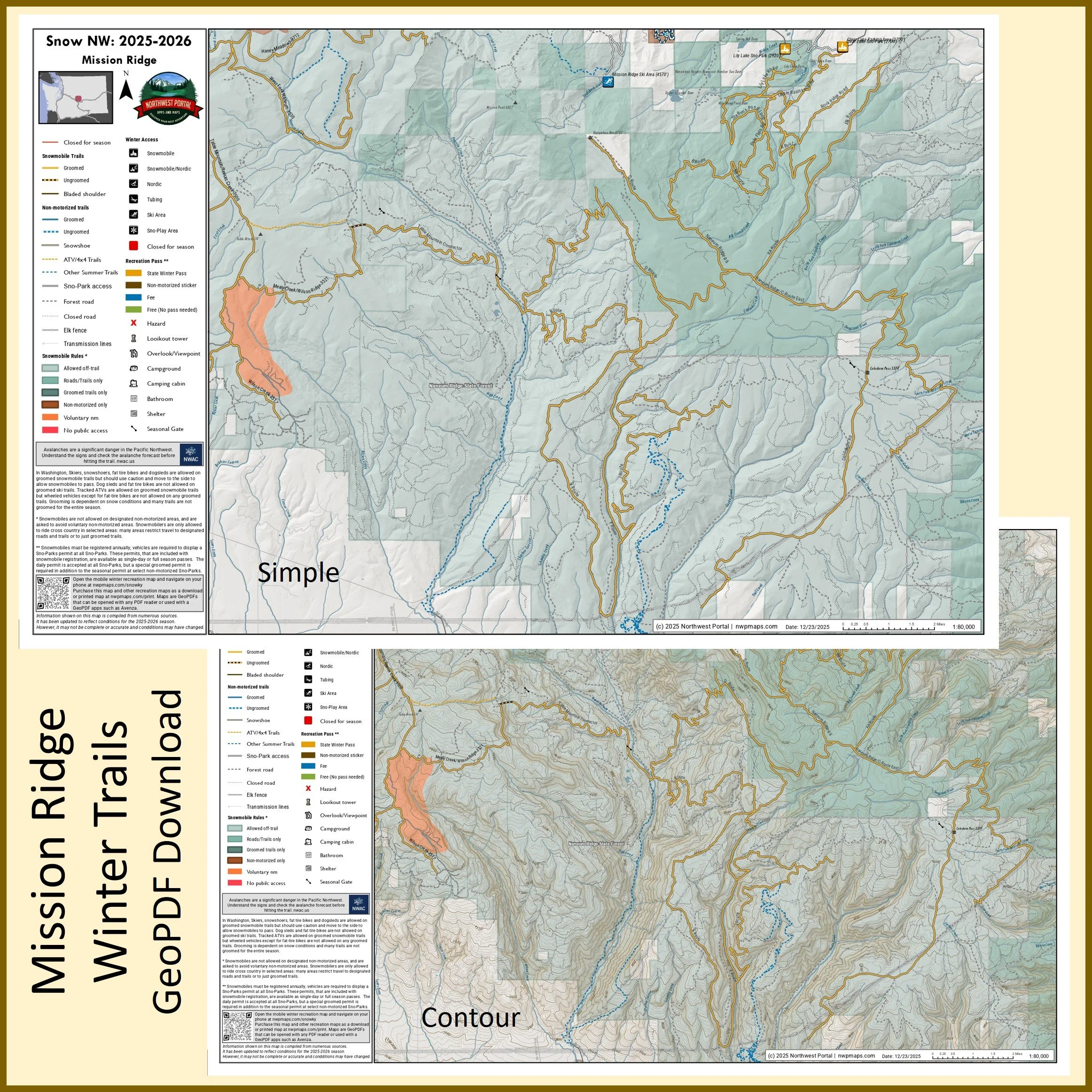
This map of winter trails on Mission Ridge between Wenatchee and Ellensburg in Kittitas and Chelan County, Washington is part of a series of winter recreation map that show where you can ride your sled, ski or snowshoe in the Pacific Northwest. See which trails are groomed, what areas snowmobiles are allowed and where they are restricted. The maps, which were updated for the 2025-2026 season, include shelters, campgrounds, viewpoints, fire towers as well as summer trails and recreation roads, that are often utilized for winter recreation, campgrounds. The map is a tabloid sized (11x17”) PDF at a 1:90,000 scale that you can print or use with a GeoPDF app such as Avenza. You will receive two versions of the map, one with contour lines and one without. The map includes trails out of the Clear Lake and Lily Lake Sno-Parks and trailheads.
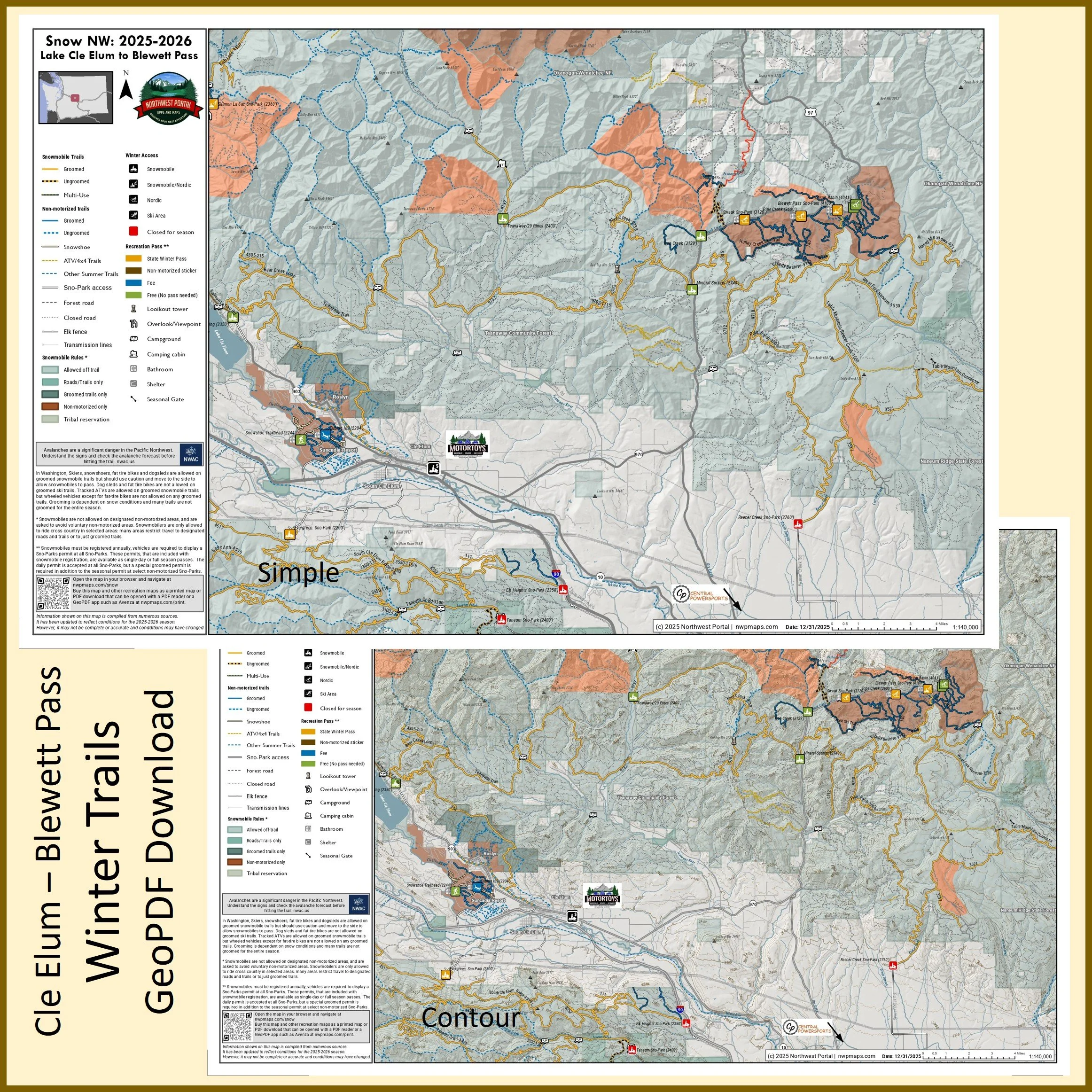
This map of winter trails in North Kittitas County Washington is part of a series of winter recreation map that show where you can ride your sled, ski or snowshoe in the Pacific Northwest. See which trails are groomed, what areas snowmobiles are allowed and where they are restricted. The maps, which were updated for the 2025-2026 season, include shelters, campgrounds, viewpoints, fire towers as well as summer trails and recreation roads, that are often utilized for winter recreation, campgrounds. The map is a tabloid sized (11x17”) PDF at a 1:150,000 scale that you can print or use with a GeoPDF app such as Avenza. You will receive two versions of the map, one with contour lines and one without. The map includes trails and trailhead from the Last Resort on Lake Cle Elum across the Teanaway Community Forest to Blewett Pass and the Table Mountain Area.
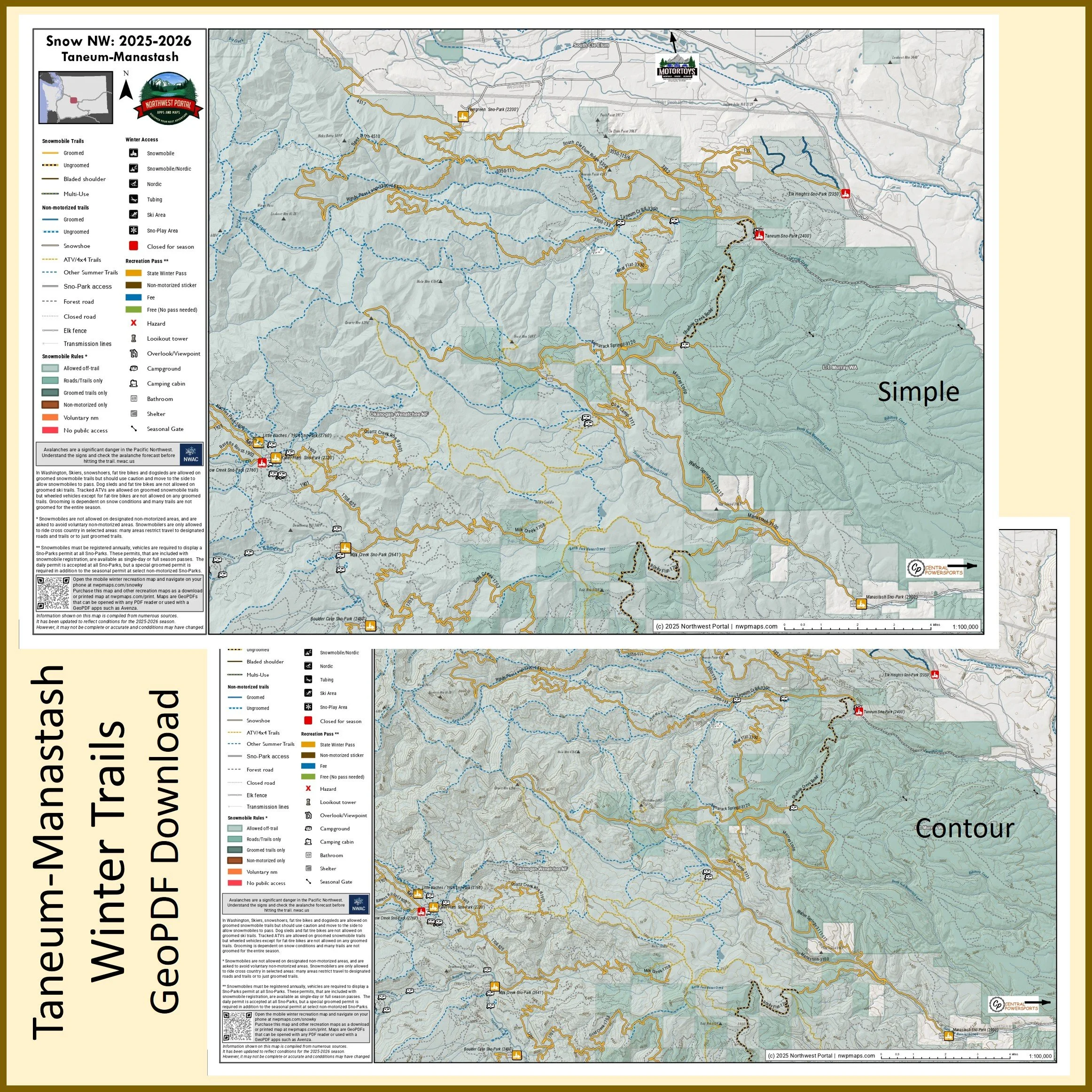
This map of winter trails in the Taneum/Manastash area of Kittitas County, Washington is part of a series of winter recreation map that show where you can ride your sled, ski or snowshoe in the Pacific Northwest. See which trails are groomed, what areas snowmobiles are allowed and where they are restricted. The maps, which were updated for the 2025-2026 season, include shelters, campgrounds, viewpoints, fire towers as well as summer trails and recreation roads, that are often utilized for winter recreation, campgrounds. The map is a tabloid sized (11x17”) PDF at a 1:100,000 scale that you can print or use with a GeoPDF app such as Avenza. You will receive two versions of the map, one with contour lines and one without. The map includes trails out of the Little Naches/1904, Kaner Flats, Milk Creek, Boulder Cave, Manastash, and Evergreen Sno-Parks and trailheads.
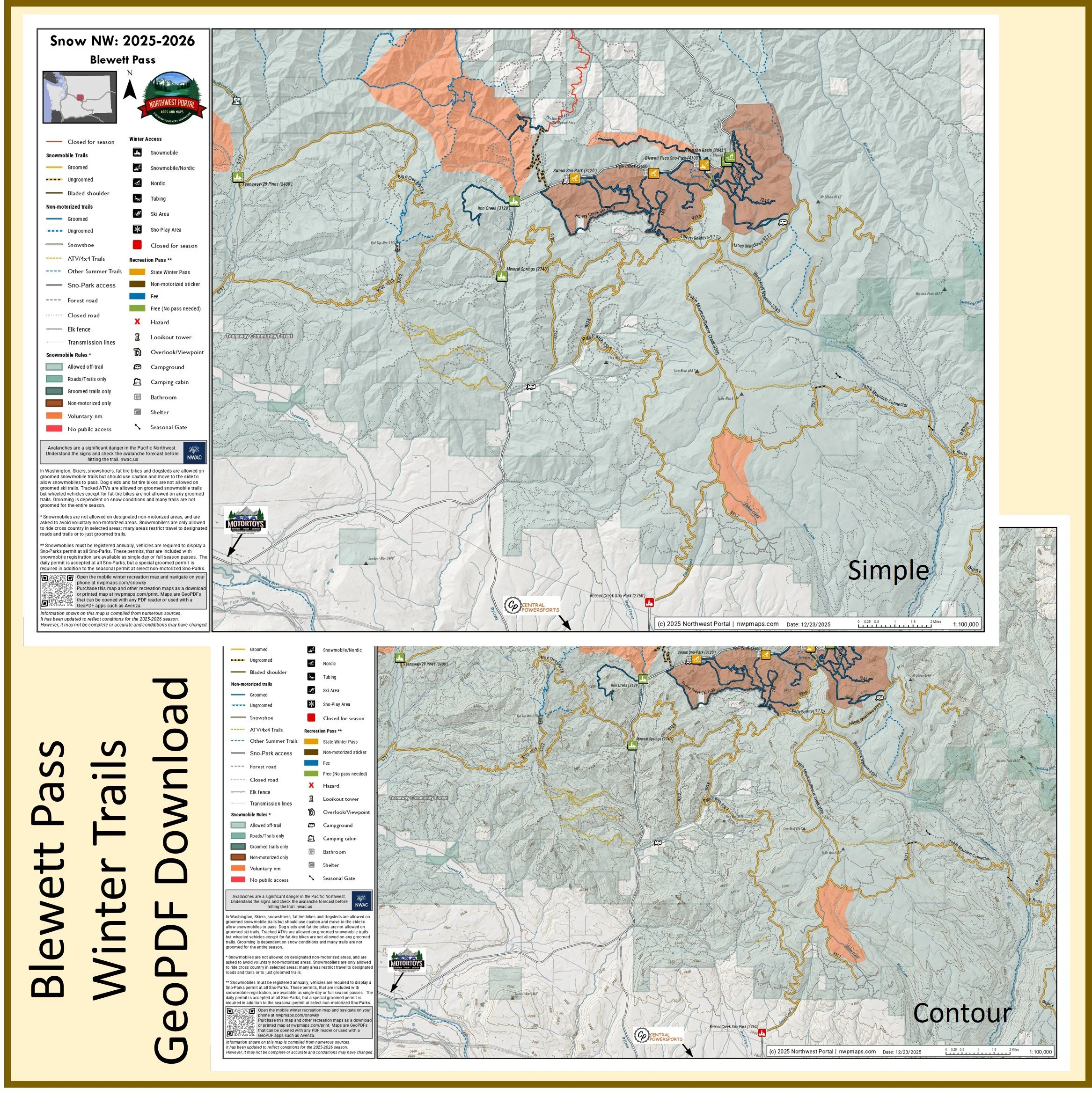
This map of winter trails on Blewett Pass in Kittitas County, Central Washington is part of a series of winter recreation map that show where you can ride your sled, ski or snowshoe in the Pacific Northwest. See which trails are groomed, what areas snowmobiles are allowed and where they are restricted. The maps, which were updated for the 2025-2026 season, include shelters, campgrounds, viewpoints, fire towers as well as summer trails and recreation roads, that are often utilized for winter recreation, campgrounds. The map is a tabloid sized (11x17”) PDF at a 1:100,000 scale that you can print or use with a GeoPDF app such as Avenza. You will receive two versions of the map, one with contour lines and one without. The map includes trails out of the Teanaway/29 Pines, Iron Creek, Mineral Springs, Swauk, Pipe Creek, Blewett Pass and Tronson Basin Sno-Parks and trailheads.
Northwest Washington
Whatcom & Skagit Counties
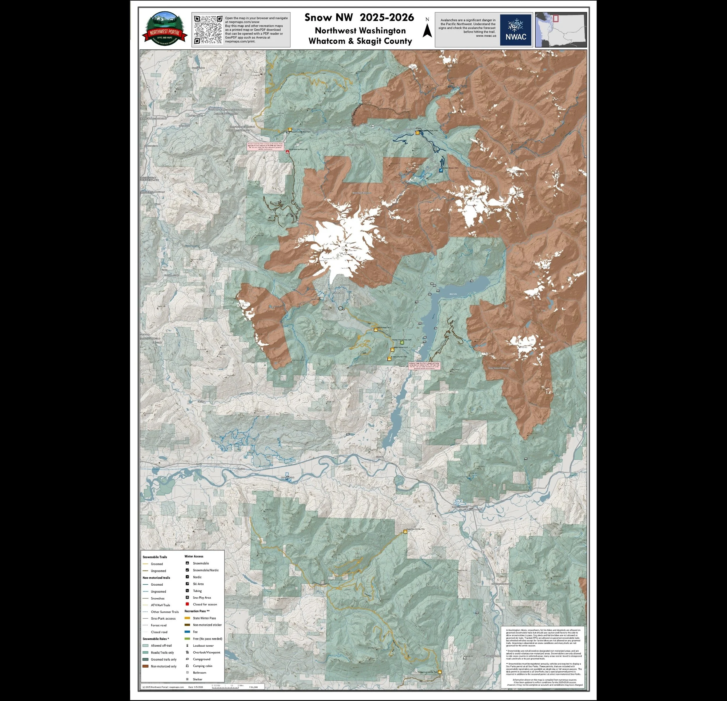
This map of winter trails in Whatcom and Skagit County, Washington is part of a series of winter recreation map that show where you can ride your snowmobile, ski or snowshoe in the Pacific Northwest. See which trails are groomed, what areas snowmobiles are allowed and where they are restricted. The maps, which were updated for the 2025-2026 season, include shelters, campgrounds, viewpoints, fire towers as well as summer trails and recreation roads, that are often utilized for winter recreation, campgrounds. It is a poster sized sized (24x36”) GeoPDF at a 1:65,000 scale that you can print, view in your browser or use with a GeoPDF app such as Avenza. The map includes several groomed snowmobile trail systems: Whatcom County’s Canyon Creek and Mount Baker Recreation Area trails, and trails out of Skagit County’s Finney Creek and Segelsen Creek Sno-Parks.
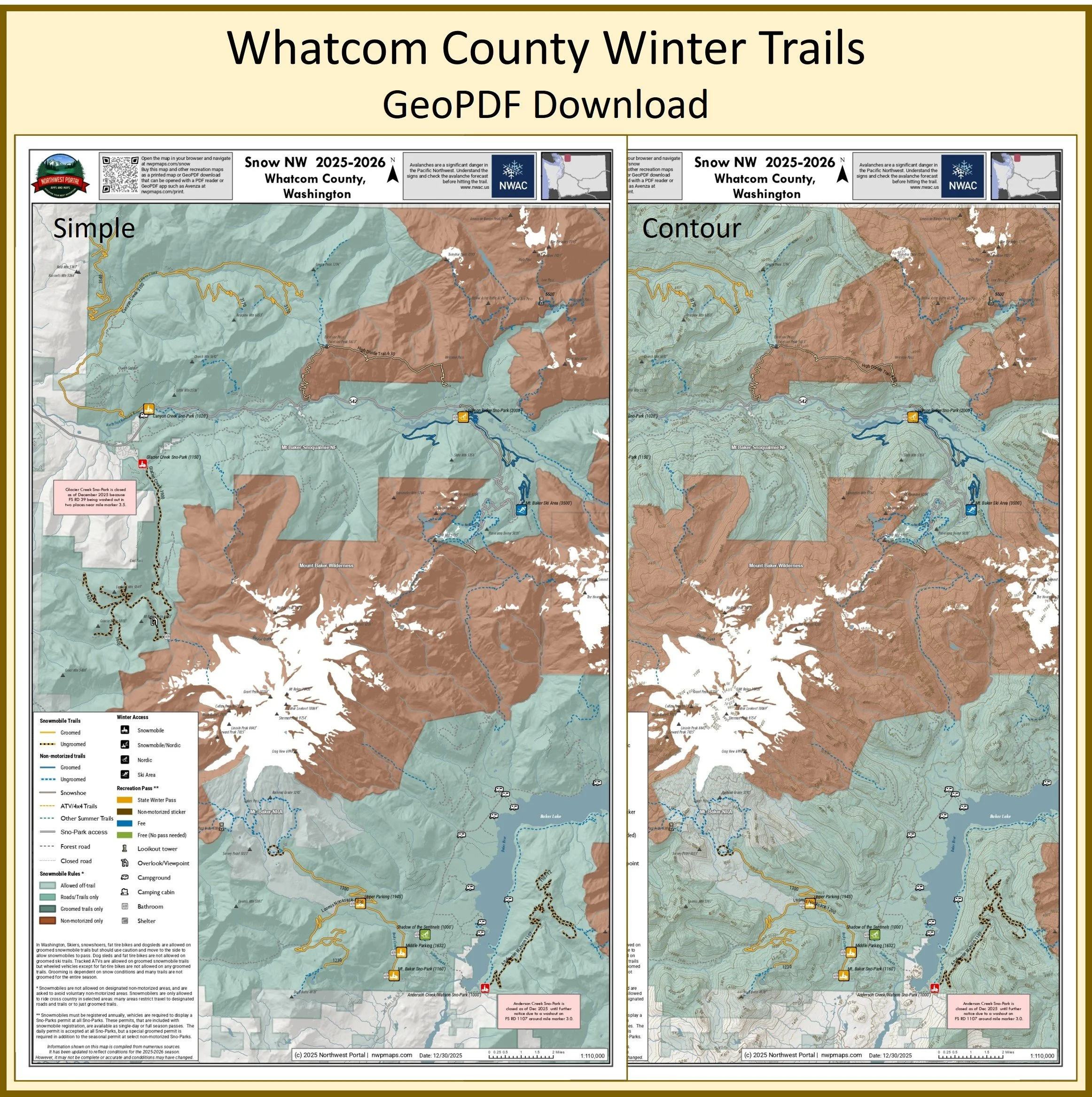
This map of winter trails in the Whatcom County, Washington is part of a series of winter recreation map that show where you can ride your sled, ski or snowshoe in the Pacific Northwest. See which trails are groomed, what areas snowmobiles are allowed and where they are restricted. The maps, which were updated for the 2025-2026 season, include shelters, campgrounds, viewpoints, fire towers as well as summer trails and recreation roads, that are often utilized for winter recreation. The map is a tabloid sized (11x17”) PDF at a 1:110,000 scale that you can print or use with a GeoPDF app such as Avenza. You will receive two versions of the map, one with contour lines and one without. The map includes trails in the Mount Baker National Recreation Area, and those out of the Anderson Creek, Canyon Creek, Glacier Creek and Salmon Ridge Sno-Parks.
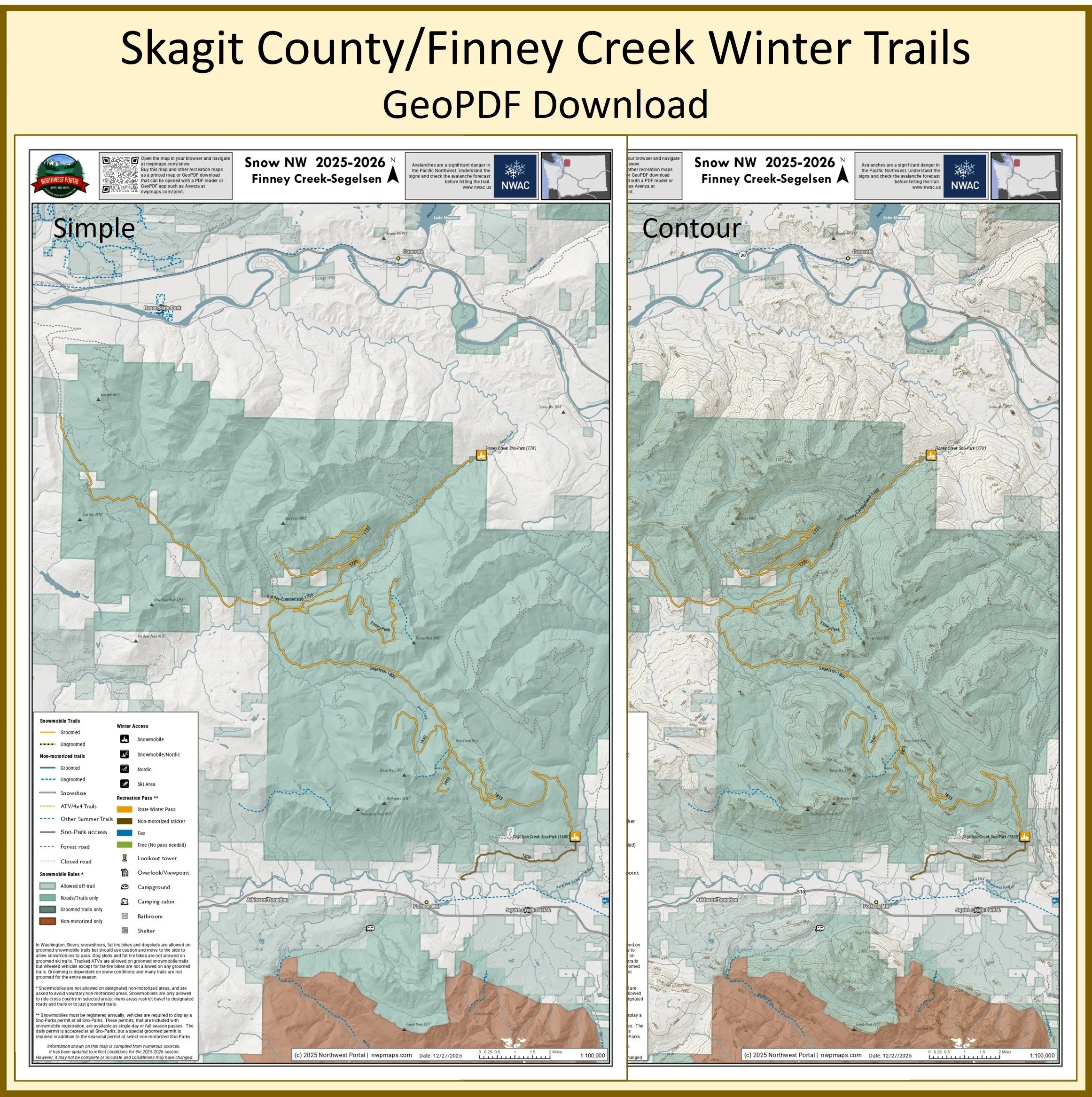
This map of winter trails in Skagit County, Washington is part of a series of winter recreation map that show where you can ride your sled, ski or snowshoe in the Pacific Northwest. See which trails are groomed, what areas snowmobiles are allowed and where they are restricted. The maps, which were updated for the 2025-2026 season, include shelters, campgrounds, viewpoints, fire towers as well as summer trails and recreation roads, that are often utilized for winter recreation, campgrounds. The map is a tabloid sized (11x17”) PDF at a 1:100,000 scale that you can print or use with a GeoPDF app such as Avenza. You will receive two versions of the map, one with contour lines and one without. The map includes trails out of the Finney Creek & Segelsen Sno-Parks.
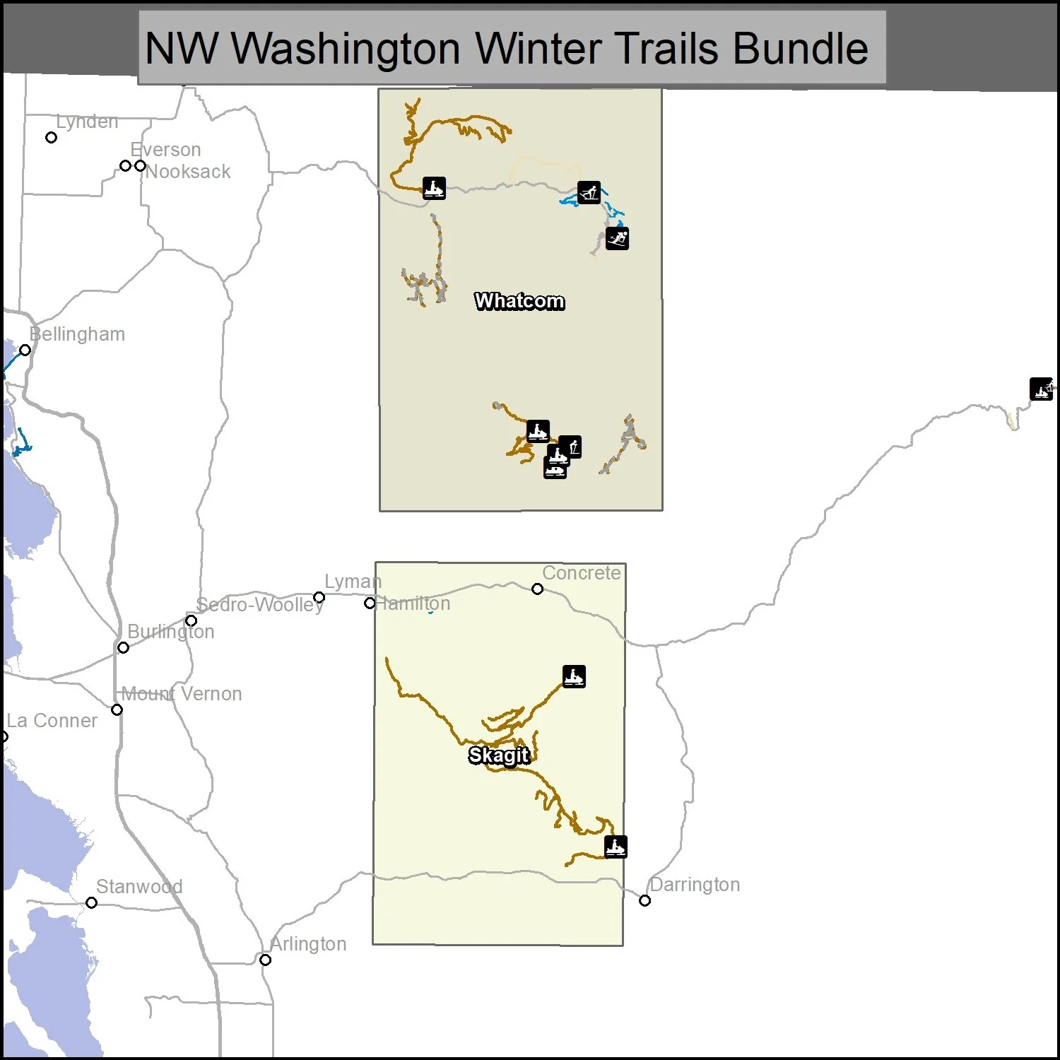
This bundle includes two maps of winter trails in NW Washington: Whatcom County and Skagit County, Washington. It is part of a series of winter recreation map that show where you can ride your sled, ski or snowshoe in the Pacific Northwest. See which trails are groomed, what areas snowmobiles are allowed and where they are restricted. The maps, which were updated for the 2025-2026 season, include shelters, campgrounds, viewpoints, fire towers as well as summer trails and recreation roads, that are often utilized for winter recreation, campgrounds. The maps are tabloid sized (11x17”) PDFs at 1:100,000 and 1:110,000 scale that you can print or use with a GeoPDF app such as Avenza. You will receive two versions of each map, one with contour lines and one without.
Yakima County Washington
Greenwater, Naches & Ahtanum State Forest
Tabloid
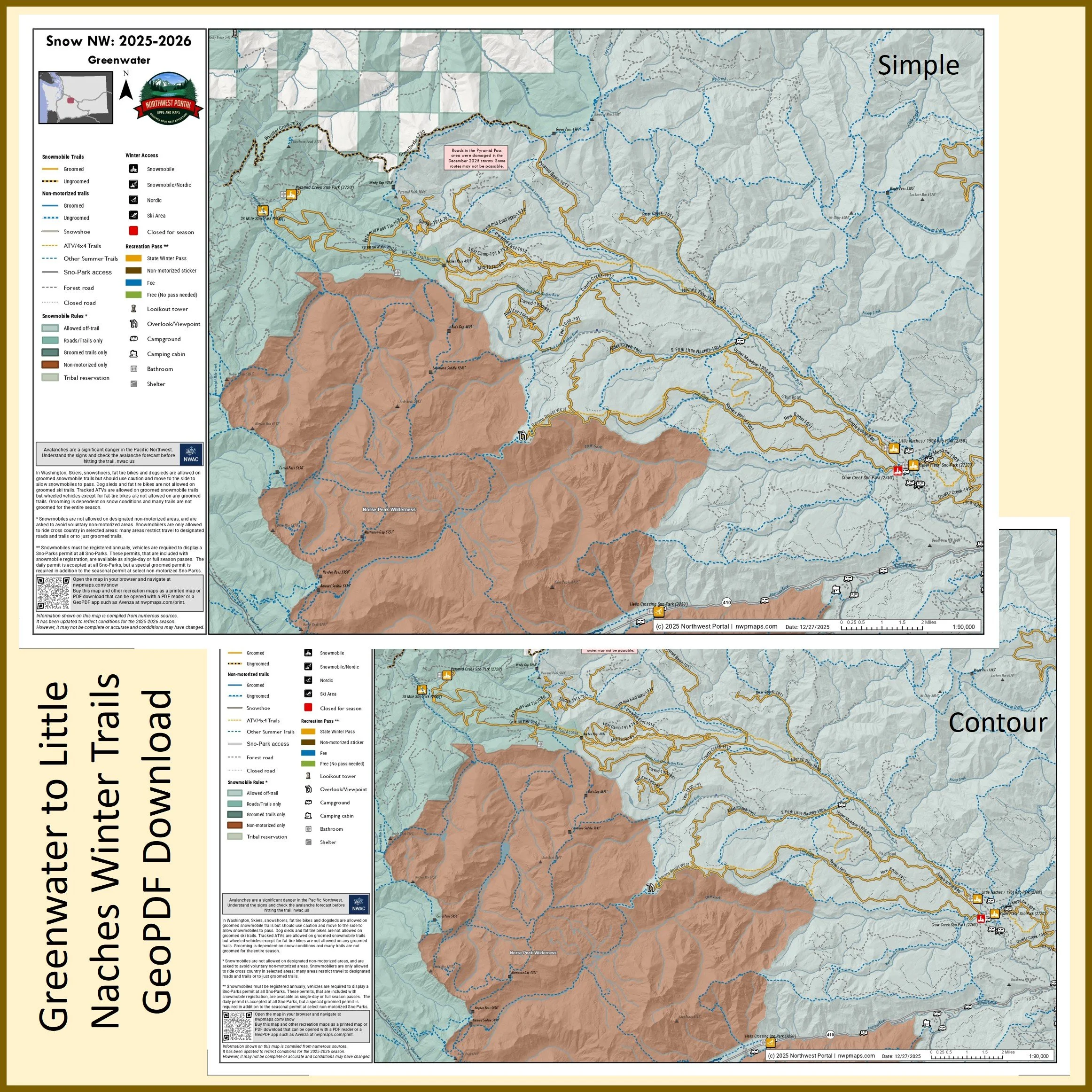
This map of winter trails in the Greenwater area of upper Yakima County, Washington is part of a series of winter recreation map that show where you can ride your sled, ski or snowshoe in the Pacific Northwest. See which trails are groomed, what areas snowmobiles are allowed and where they are restricted. The maps, which were updated for the 2025-2026 season, include shelters, campgrounds, viewpoints, fire towers as well as summer trails and recreation roads, that are often utilized for winter recreation, campgrounds. The map is a tabloid sized (11x17”) PDF at a 1:100,000 scale that you can print or use with a GeoPDF app such as Avenza. You will receive two versions of the map, one with contour lines and one without. The map includes trails out of the Hells Crossing, Little Naches/1904, Kaner Flats, Pyramid Creek, and 28 Mile Sno-Parks and trailheads.
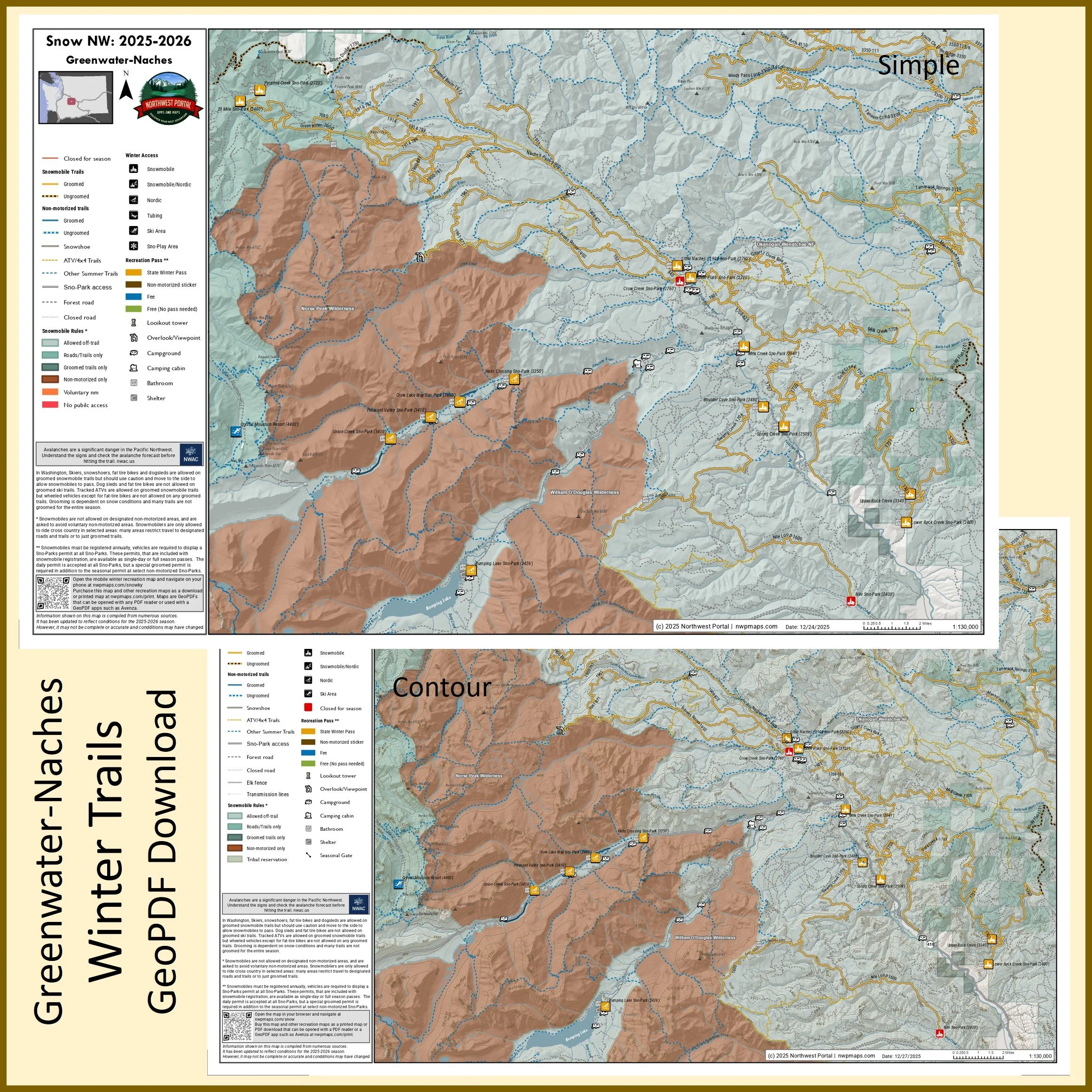
This map of winter trails from Greenwater to Naches in Yakima County, Washington is part of a series of winter recreation map that show where you can ride your sled, ski or snowshoe in the Pacific Northwest. See which trails are groomed, what areas snowmobiles are allowed and where they are restricted. The maps, which were updated for the 2025-2026 season, include shelters, campgrounds, viewpoints, fire towers as well as summer trails and recreation roads, that are often utilized for winter recreation, campgrounds. The map is a tabloid sized (11x17”) PDF at a 1:130,000 scale that you can print or use with a GeoPDF app such as Avenza. You will receive two versions of the map, one with contour lines and one without. The map includes trails out of the Pyramid Creek, 28 Mile, Union Creek, Pleasant Valley, Crow Lake Way, Hells Crossing, Bumping Lake, Lower Rock Creek, Upper Rock Creek, Spring Creek, Boulder Cave, Milk Creek, Kaner Flats, and Little Naches/1904 Sno-Parks and trailheads.
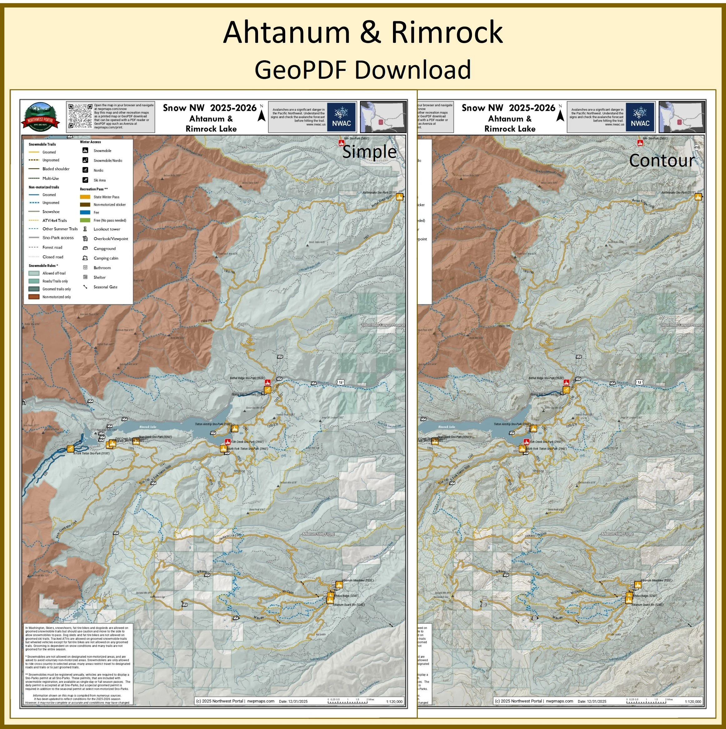
This map of winter trails in southern Yakima County, Washington is part of a series of winter recreation map that show where you can ride your sled, ski or snowshoe in the Pacific Northwest. See which trails are groomed, what areas snowmobiles are allowed and where they are restricted. The maps, which were updated for the 2025-2026 season, include shelters, campgrounds, viewpoints, fire towers as well as summer trails and recreation roads, that are often utilized for winter recreation, campgrounds. The map is a tabloid sized (11x17”) PDF at a 1:120,000 scale that you can print or use with a GeoPDF app such as Avenza. You will receive two versions of the map, one with contour lines and one without. This map includes trails from the Rattlesnake Sno-Park to Ahtanum State Forest and around Rimrock Lake.
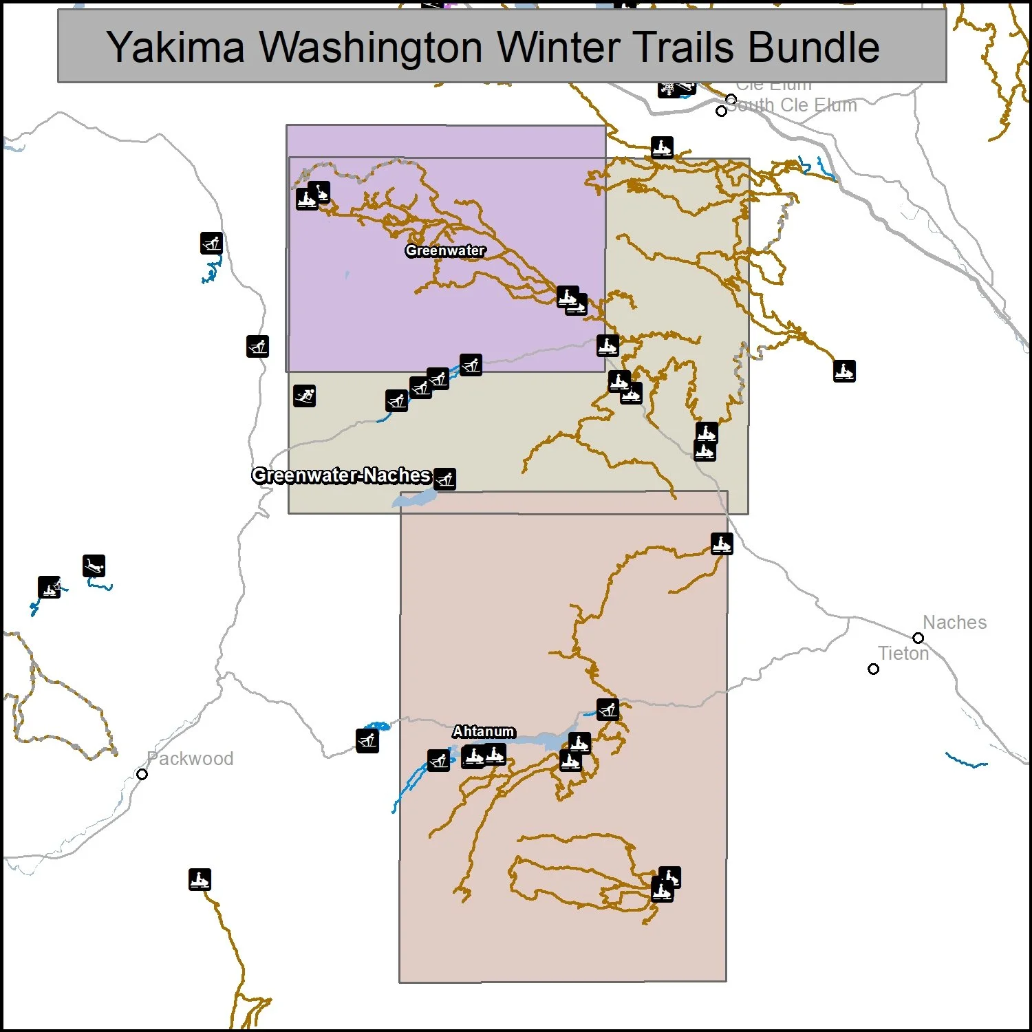
This bundle includes three maps of winter trails in Yakima County, Washington: Greenwater (1:100,000), Greenwater-Naches (1:130,000) and Ahtanum/Rimrock (1:120,000).. It is part of a series of winter recreation map that show where you can ride your sled, ski or snowshoe in the Pacific Northwest. See which trails are groomed, what areas snowmobiles are allowed and where they are restricted. The maps, which were updated for the 2025-2026 season, include shelters, campgrounds, viewpoints, fire towers as well as summer trails and recreation roads, that are often utilized for winter recreation, campgrounds. The maps are tabloid sized (11x17”) PDFs that you can print or use with a GeoPDF app such as Avenza. You will receive two versions of each map, one with contour lines and one without.
Poster
This map shows the connected groomed snowmobile trail system from Crystal Springs near Snoqualmie Pass in Kittitas County to Greenwater at the top of the Naches watershed in Yakima County. It also includes the Salmon La Sac trail system, trails between lake Kachees and Lake Cle Elum and the Teanaway Community Forest. For Nordic skiers, snowshoers and dogsledders it includes the Snoqualmie Nordic Center, Crystal Springs/Cabin Creek Trails, Suncadia trails and Hells Crossing Nordic Trails. It is part of a series of winter recreation map that show where you can ride your sled, ski or snowshoe in the Pacific Northwest. See which trails are groomed, what areas snowmobiles are allowed and where they are restricted. The maps, which were updated for the 2025-2026 season, include shelters, campgrounds, viewpoints, fire towers as well as summer trails and recreation roads, that are often utilized for winter recreation, campgrounds. It is a poster sized sized (24x36”) GeoPDF at a 1:90,000 scale that you can print, view in your browser or use with a GeoPDF app such as Avenza.
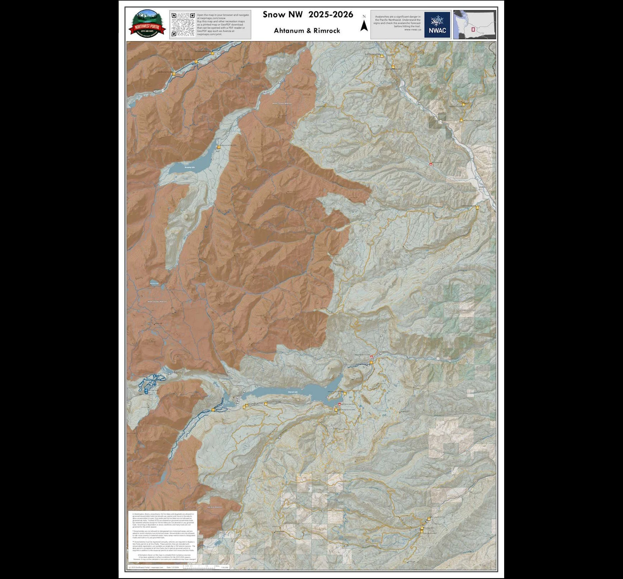
This map of winter trails in southern Yakima County, Washington is part of a series of winter recreation map that show where you can ride your snowmobile, ski or snowshoe in the Pacific Northwest. See which trails are groomed, what areas snowmobiles are allowed and where they are restricted. The maps, which were updated for the 2025-2026 season, include shelters, campgrounds, viewpoints, fire towers as well as summer trails and recreation roads, that are often utilized for winter recreation, campgrounds. It is a poster sized sized (24x36”) GeoPDF at a 1:65,000 scale that you can print, view in your browser or use with a GeoPDF app such as Avenza This map includes trails from the Rattlesnake Sno-Park to Ahtanum State Forest and around Rimrock Lake. It also inludes the White Pass and North Fork Tieton Nordic Trails.
Republic Area
Colville National Forest
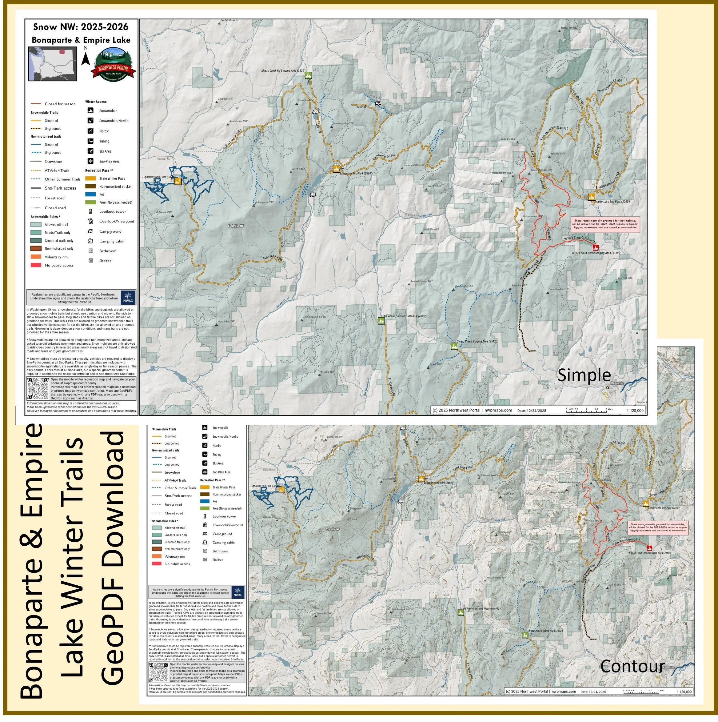
This map of winter trails in Colville National Forest in Okanogan & Ferry County, is part of a series of winter recreation map that show where you can ride your sled, ski or snowshoe in the Pacific Northwest. See which trails are groomed, what areas snowmobiles are allowed and where they are restricted. The maps, which were updated for the 2025-2026 season, include shelters, campgrounds, viewpoints, fire towers as well as summer trails and recreation roads, that are often utilized for winter recreation, campgrounds. The map is a tabloid sized (11x17”) PDF at a 1:120,000 scale that you can print or use with a GeoPDF app such as Avenza. You will receive two versions of the map, one with contour lines and one without. The map includes trails out of the Highlands, Bonaparte, Myers Creek, Empire Lake and West Fork Trout Creek Sno-Parks and Staging Areas.
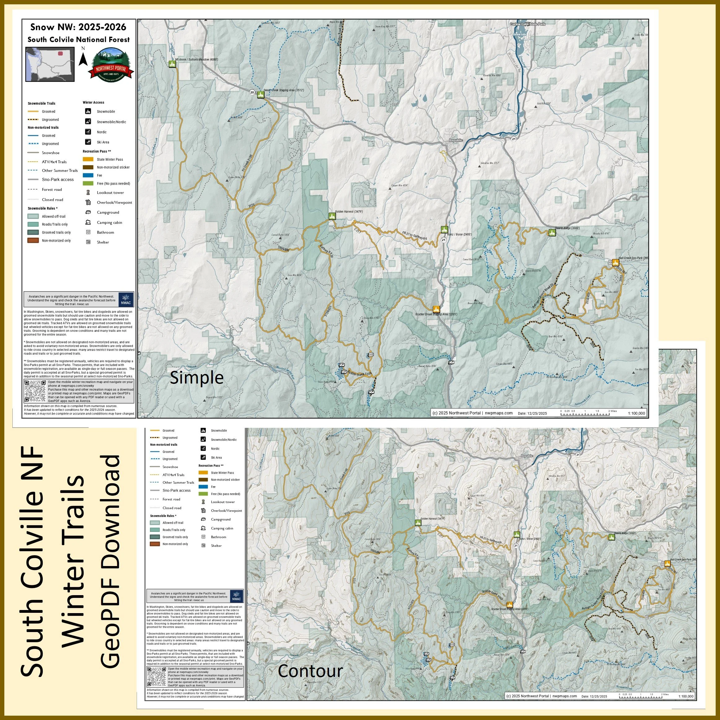
This map of winter trails in the southern part of Colville National Forest in Okanogan and Ferry County, Washington is part of a series of winter recreation map that show where you can ride your sled, ski or snowshoe in the Pacific Northwest. See which trails are groomed, what areas snowmobiles are allowed and where they are restricted. The maps, which were updated for the 2025-2026 season, include shelters, campgrounds, viewpoints, fire towers as well as summer trails and recreation roads, that are often utilized for winter recreation, campgrounds. The map is a tabloid sized (11x17”) PDF at a 1:100,000 scale that you can print or use with a GeoPDF app such as Avenza. You will receive two versions of the map, one with contour lines and one without. The map includes trails out of the Scatter Creek and Hall Creek Sno-Parks and trailheads.
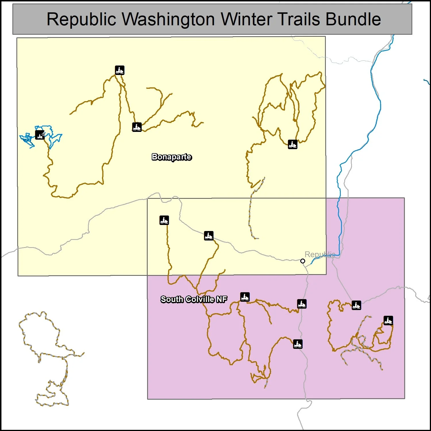
This bundle includes two maps of winter trails in Colville National Forest near Republic, Washington: Bonaparte-Empire Lake (1:120,000) and South Colville (1:100,000). It is part of a series of winter recreation map that show where you can ride your sled, ski or snowshoe in the Pacific Northwest. See which trails are groomed, what areas snowmobiles are allowed and where they are restricted. The maps, which were updated for the 2025-2026 season, include shelters, campgrounds, viewpoints, fire towers as well as summer trails and recreation roads, that are often utilized for winter recreation, campgrounds. The maps are tabloid sized (11x17”) PDFs that you can print or use with a GeoPDF app such as Avenza. You will receive two versions of each map, one with contour lines and one without.
Southwest Washington
Gifford Pinchot National Forest
Poster (18x24”) and Tabloid (11x17”) maps
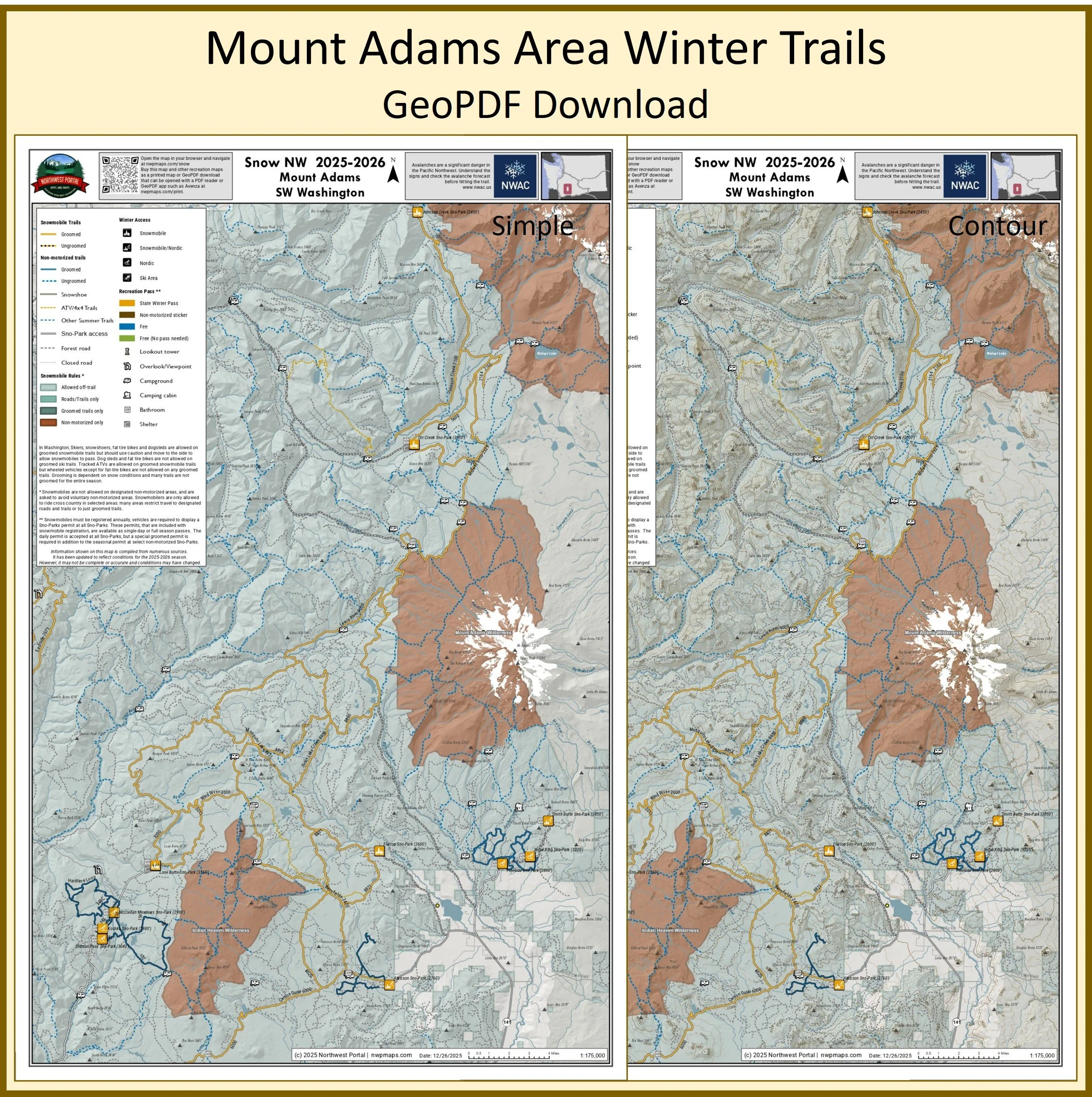
This map of the winter trails in the Mount Adams Area of Gifford Pinchot National Forest, Skamania County, Washington is part of a series of winter recreation map that show where you can ride your sled, ski, dogsled or snowshoe in the Pacific Northwest. See which trails are groomed, what areas snowmobiles are allowed and where they are restricted. The map, which was updated for the 2025-2026 season, include shelters, campgrounds, viewpoints, fire towers as well as summer trails and recreation roads, that are often utilized for winter recreation, campgrounds. It is a poster sized sized (24x36”) GeoPDF at a 1:85,000 scale that you can print, view in your browser or use with a GeoPDF app such as AvenzaThe map also shows 4x4 and other summer trails and recreation roads to assist in navigation. Public lands are color coded to show where users can ride off-road/trail, where they must stay on trail and areas where snowmobiles are not allowed. The map includes trails out of Johnson Creek, Marble Mountain, Wakepish, Curley Creek, Lone Butte, Orr Creek, Flattop and Atkisson Sno-Parks as well as the Nordic and snowshoe trails from McClellan Meadows, Oldman, Pineside and Snow King Sno-Parks.
This map of winter trails in the Mount Adams area of Skamania County in Southwest Washington is part of a series of winter recreation map that show where you can ride your sled, ski or snowshoe in the Pacific Northwest. See which trails are groomed, what areas snowmobiles are allowed and where they are restricted. The maps, which were updated for the 2025-2026 season, include shelters, campgrounds, viewpoints, fire towers as well as summer trails and recreation roads, that are often utilized for winter recreation, campgrounds. The map is a tabloid sized (11x17”) PDF at a 1:175,000 scale that you can print or use with a GeoPDF app such as Avenza. You will receive two versions of the map, one with contour lines and one without. The map includes trails out of the Orr Creek, Oldman Pass, Koshko, McClellan Meadows, Lone Butte, Flattop, Atkisson, Pineside, Snow King, Smith Butte, and Johnson Creek Sno-Parks and trailheads.
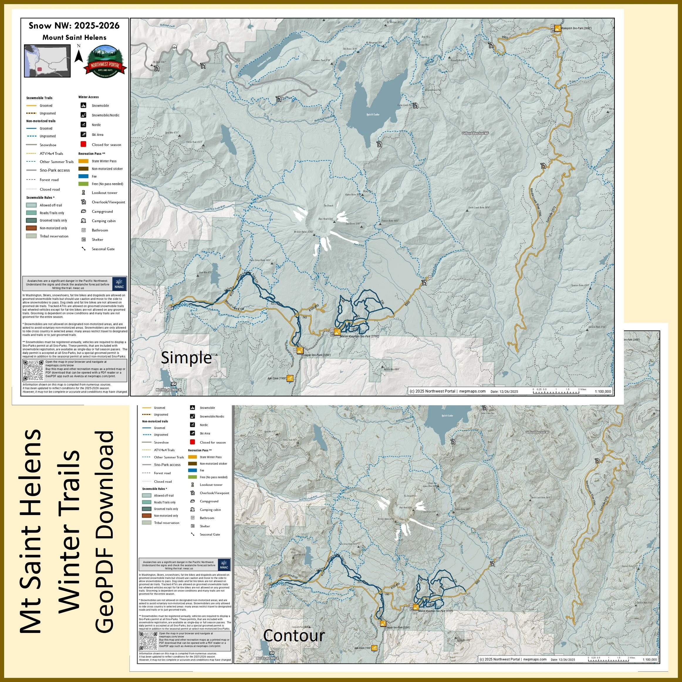
This map of winter trails in the Mount Saint Helens area of Skamania County in Southwest Washington is part of a series of winter recreation map that show where you can ride your sled, ski or snowshoe in the Pacific Northwest. See which trails are groomed, what areas snowmobiles are allowed and where they are restricted. The maps, which were updated for the 2025-2026 season, include shelters, campgrounds, viewpoints, fire towers as well as summer trails and recreation roads, that are often utilized for winter recreation, campgrounds. The map is a tabloid sized (11x17”) PDF at a 1:100,000 scale that you can print or use with a GeoPDF app such as Avenza. You will receive two versions of the map, one with contour lines and one without. The map includes trails out of the Marble Mountain, Cougar, and Ape Cave Sno-Parks and trailheads.
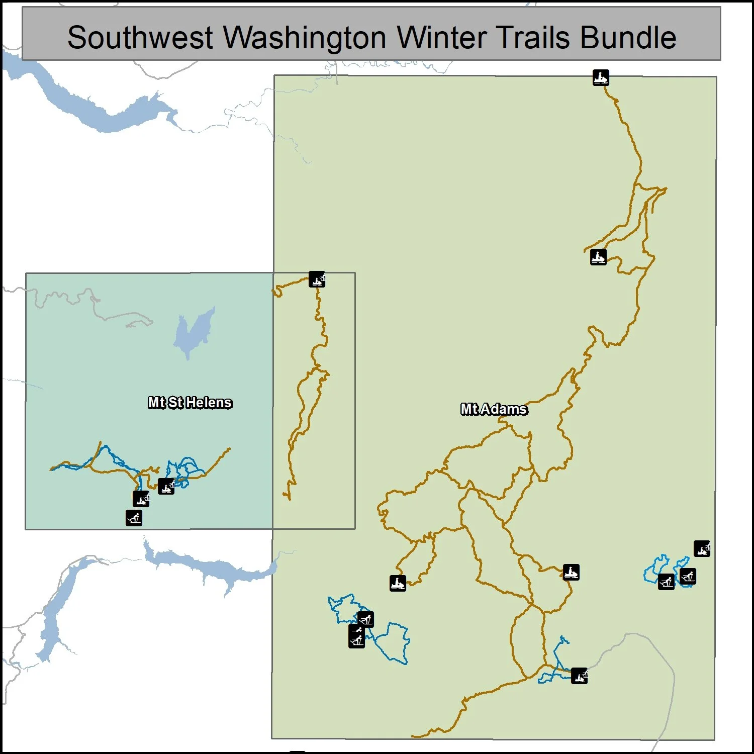
This bundle includes two maps of winter trails in Gifford Pinchot National Forest in Skamania County, Washington: Mount Saint Helens (1:100,000) and Muont Adamas (1:175,000). It is part of a series of winter recreation map that show where you can ride your sled, ski or snowshoe in the Pacific Northwest. See which trails are groomed, what areas snowmobiles are allowed and where they are restricted. The maps, which were updated for the 2025-2026 season, include shelters, campgrounds, viewpoints, fire towers as well as summer trails and recreation roads, that are often utilized for winter recreation, campgrounds. The maps are tabloid sized (11x17”) PDFs that you can print or use with a GeoPDF app such as Avenza. You will receive two versions of each map, one with contour lines and one without.
Chelan County Washington
Lake Wenatchee, Entiat River & Echo Ridge
Tabloid Size (11x17”)
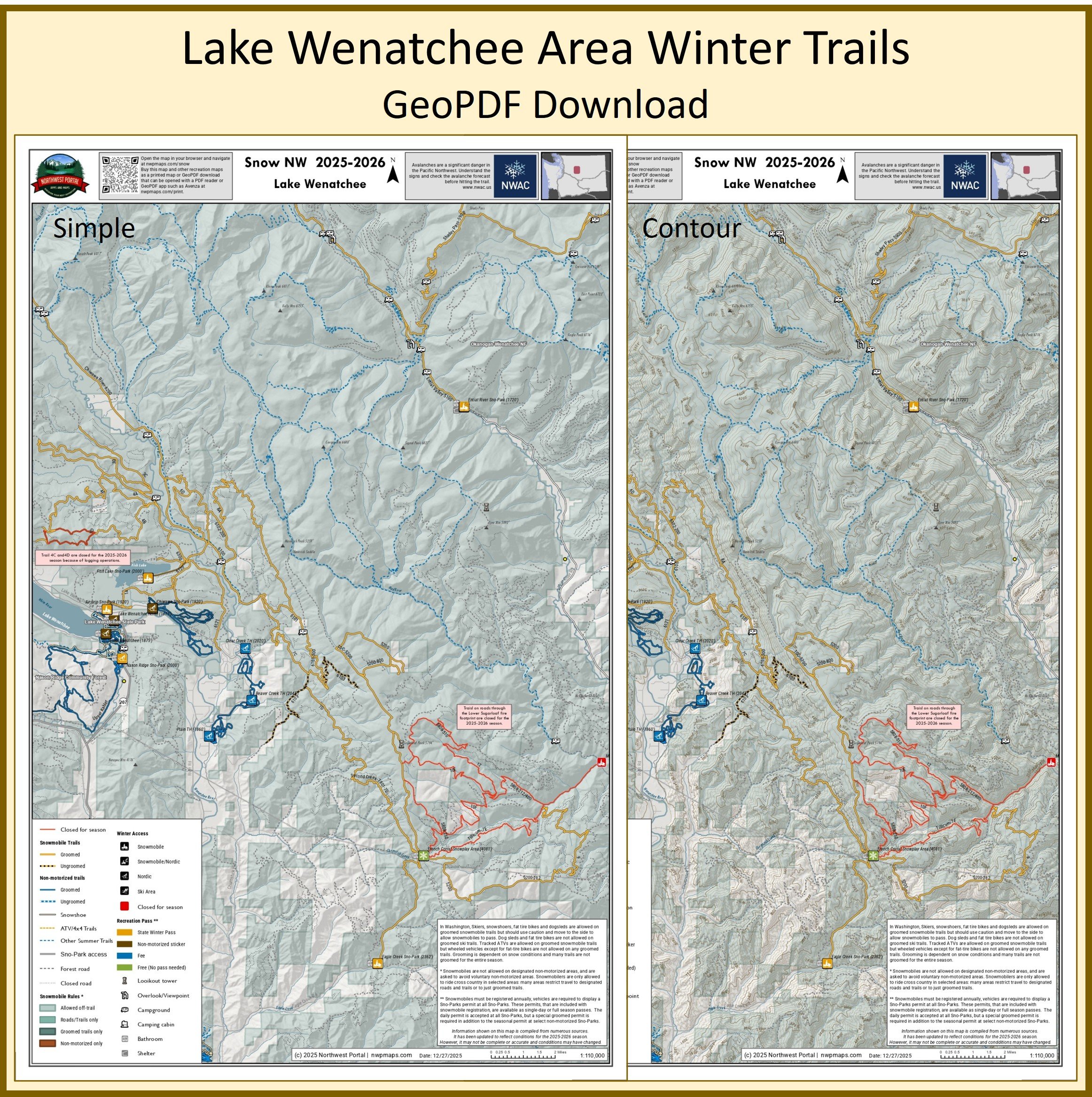
This map of winter trails in the Lake Wenatchee Area of Chelan County, Washington is part of a series of winter recreation map that show where you can ride your sled, ski or snowshoe in the Pacific Northwest. See which trails are groomed, what areas snowmobiles are allowed and where they are restricted. The maps, which were updated for the 2025-2026 season, include shelters, campgrounds, viewpoints, fire towers as well as summer trails and recreation roads, that are often utilized for winter recreation, campgrounds. The map is a tabloid sized (11x17”) PDF at a 1:110,000 scale that you can print or use with a GeoPDF app such as Avenza. You will receive two versions of the map, one with contour lines and one without. The map includes trails out of the Entiat River, Fish Lake, Airstrip, Nason Ridge, and Eagle Creek Sno-Parks and trailheads.
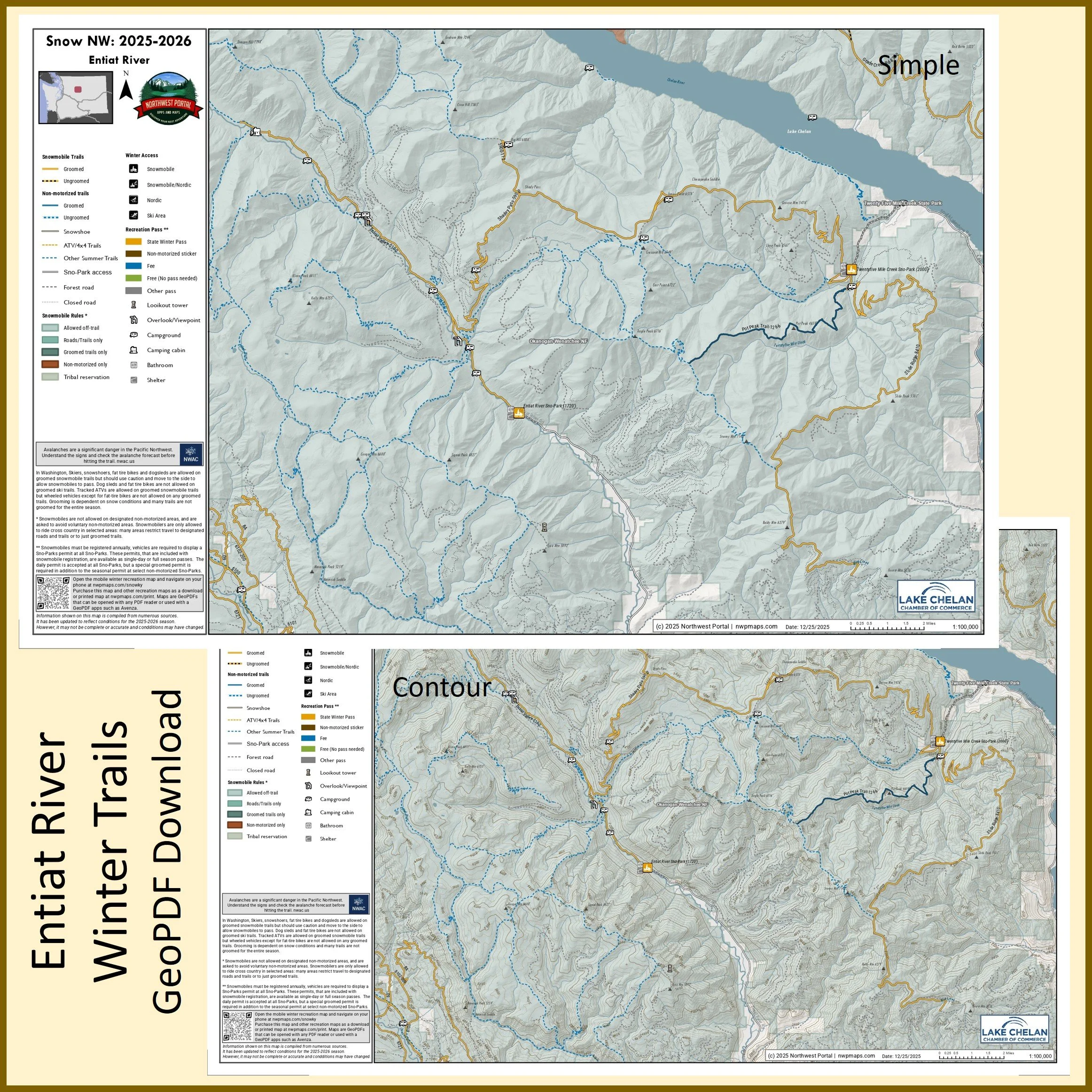
This map of winter trails in the Entiat River area of Chelan County, Washington is part of a series of winter recreation map that show where you can ride your sled, ski or snowshoe in the Pacific Northwest. See which trails are groomed, what areas snowmobiles are allowed and where they are restricted. The maps, which were updated for the 2025-2026 season, include shelters, campgrounds, viewpoints, fire towers as well as summer trails and recreation roads, that are often utilized for winter recreation, campgrounds. The map is a tabloid sized (11x17”) PDF at a 1:100,000 scale that you can print or use with a GeoPDF app such as Avenza. You will receive two versions of the map, one with contour lines and one without. The map includes trails out of the Entiat River and Twentyfile Mile Creek Sno-Parks and trailheads.
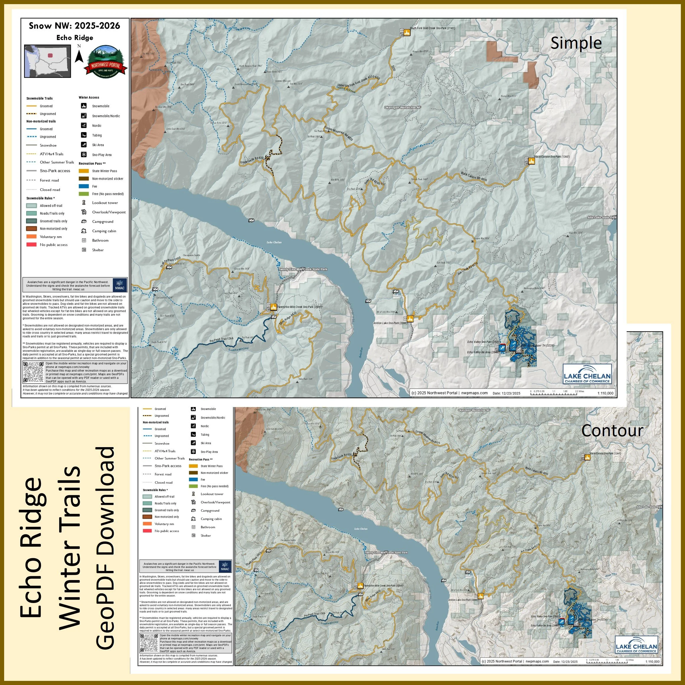
This map of winter trails in Echo Ridge in Chelan County, Washington is part of a series of winter recreation map that show where you can ride your sled, ski or snowshoe in the Pacific Northwest. See which trails are groomed, what areas snowmobiles are allowed and where they are restricted. The maps, which were updated for the 2025-2026 season, include shelters, campgrounds, viewpoints, fire towers as well as summer trails and recreation roads, that are often utilized for winter recreation, campgrounds. The map is a tabloid sized (11x17”) PDF at a 1:110,000 scale that you can print or use with a GeoPDF app such as Avenza. You will receive two versions of the map, one with contour lines and one without. The map includes trails out of the South Fork Gold Creek, Black Canyon, Twentyfive Mile Creek, and Antilon Lake Sno-Parks and trailheads.
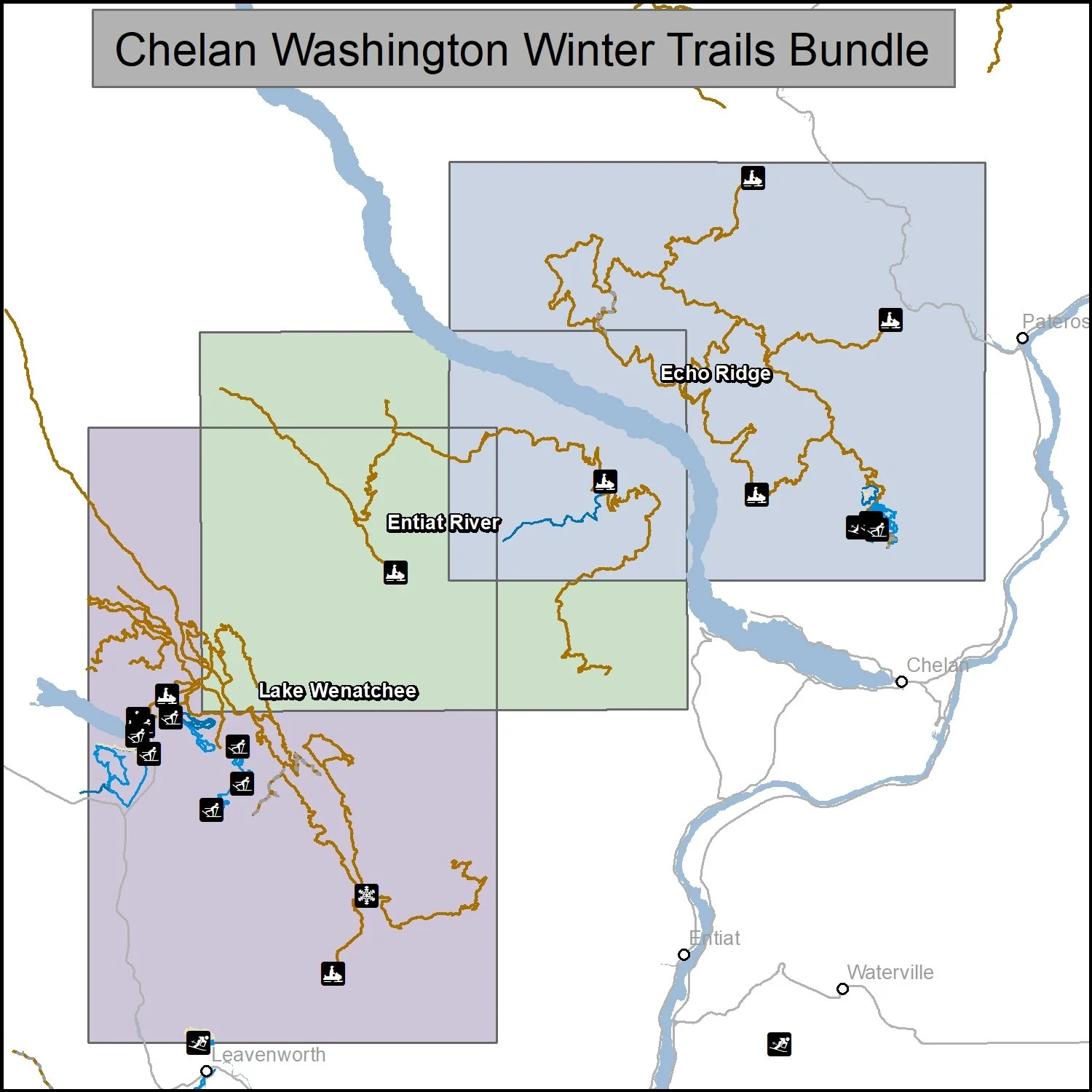
This bundle includes three maps of winter trails in Chelan County, Washington: Lake Wenatachee (1:110,000), Entiat River (1:100,000) and Echo Ridge (1:100,000).. It is part of a series of winter recreation map that show where you can ride your sled, ski or snowshoe in the Pacific Northwest. See which trails are groomed, what areas snowmobiles are allowed and where they are restricted. The maps, which were updated for the 2025-2026 season, include shelters, campgrounds, viewpoints, fire towers as well as summer trails and recreation roads, that are often utilized for winter recreation, campgrounds. The maps are tabloid sized (11x17”) PDFs that you can print or use with a GeoPDF app such as Avenza. You will receive two versions of each map, one with contour lines and one without.
Poster Size (24x36”)
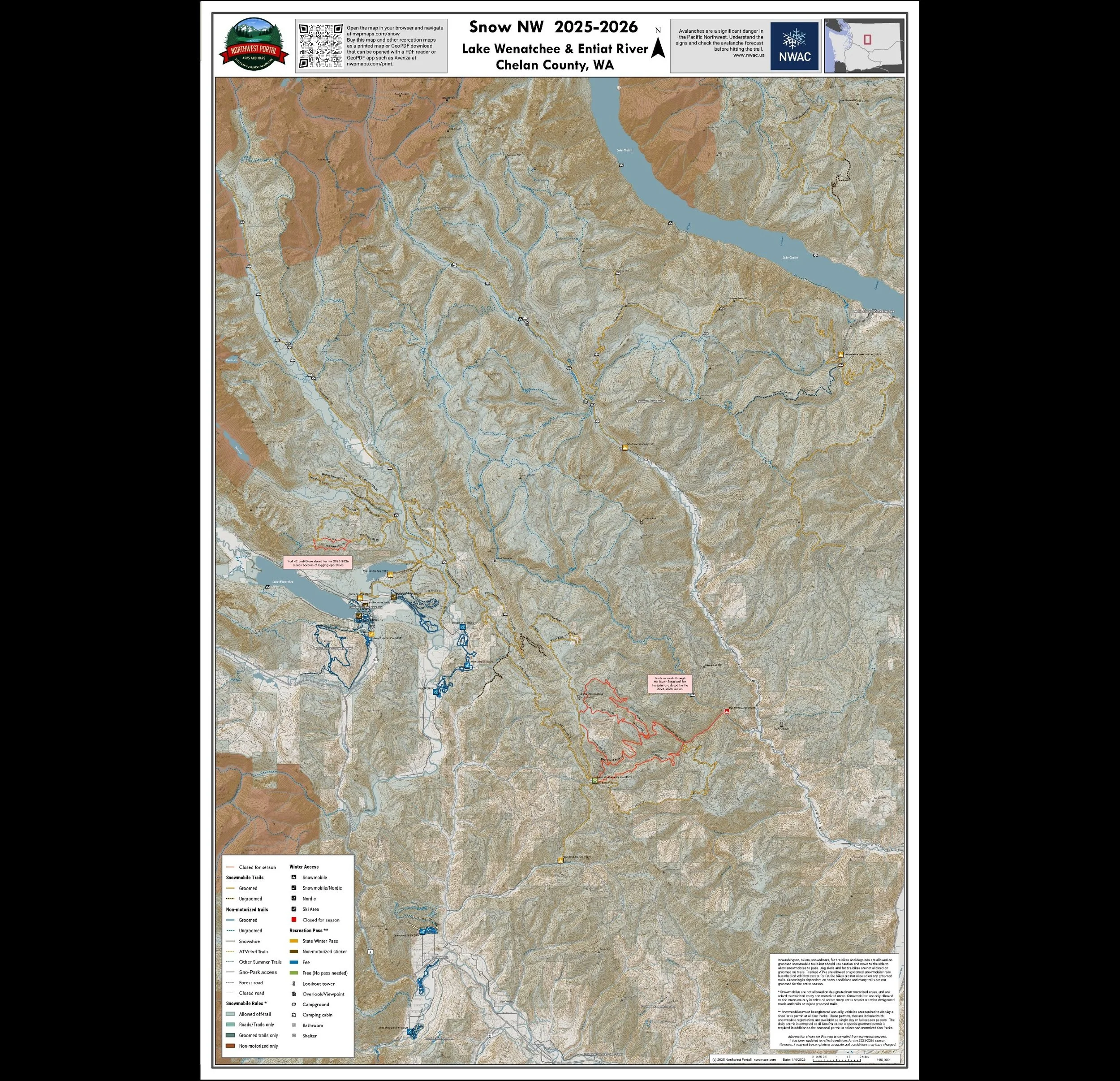
This map of winter trails in the Lake Wenatchee Area and Entiat River area of Chelan County, Washington is part of a series of winter recreation map that show where you can ride your sled, ski or snowshoe in the Pacific Northwest. See which trails are groomed, what areas snowmobiles are allowed and where they are restricted. The maps, which were updated for the 2025-2026 season, include shelters, campgrounds, viewpoints, fire towers as well as summer trails and recreation roads, that are often utilized for winter recreation, campgrounds. It is a poster sized sized (24x36”) GeoPDF at a 1:80,000 scale that you can print, view in your browser or use with a GeoPDF app such as Avenza The map includes trails out of Lake Wenatchee, Entiat River, Fish Lake, Airstrip, Nason Ridge, and Eagle Creek andTwenty five Mile Creek Sno-Parks.
Okanogan County Washington
Methow, Conconully & Twisp River
Tabloid Size (11x17”)
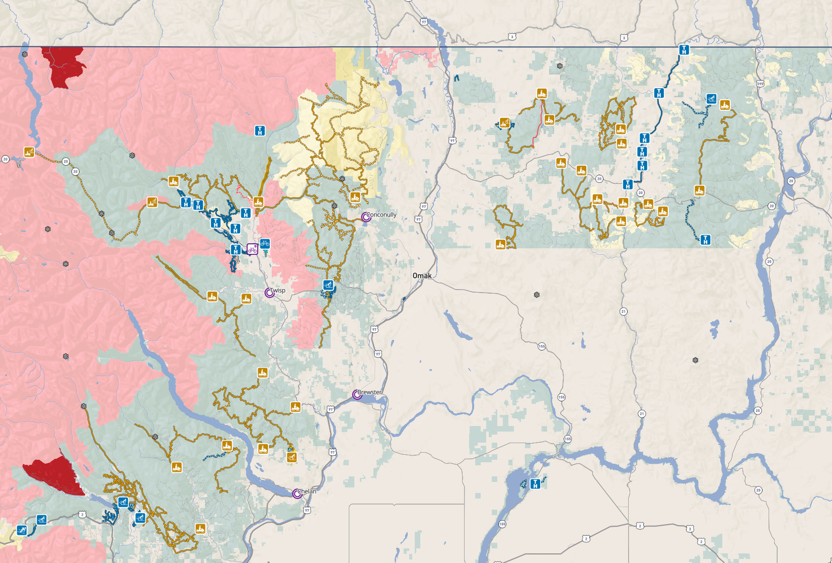
This map of snowmobile trails Methow Valley in Okanogan County, Washington is part of a series of winter recreation map that show where you can ride your sled, ski or snowshoe in the Pacific Northwest. See which trails are groomed, what areas snowmobiles are allowed and where they are restricted. The maps, which were updated for the 2025-2026 season, include shelters, campgrounds, viewpoints, fire towers as well as summer trails and recreation roads, that are often utilized for winter recreation, campgrounds. The map is a tabloid sized (11x17”) PDF at a 1:100,000 scale that you can print or use with a GeoPDF app such as Avenza. You will receive two versions of the map, one with contour lines and one without. It includes trails out of Yellow Jacket Sno-Park, Early Winter Access, Goat Creek Sno-Park, Eightmile Sno-Park and Boulder Creek Sno-Park.
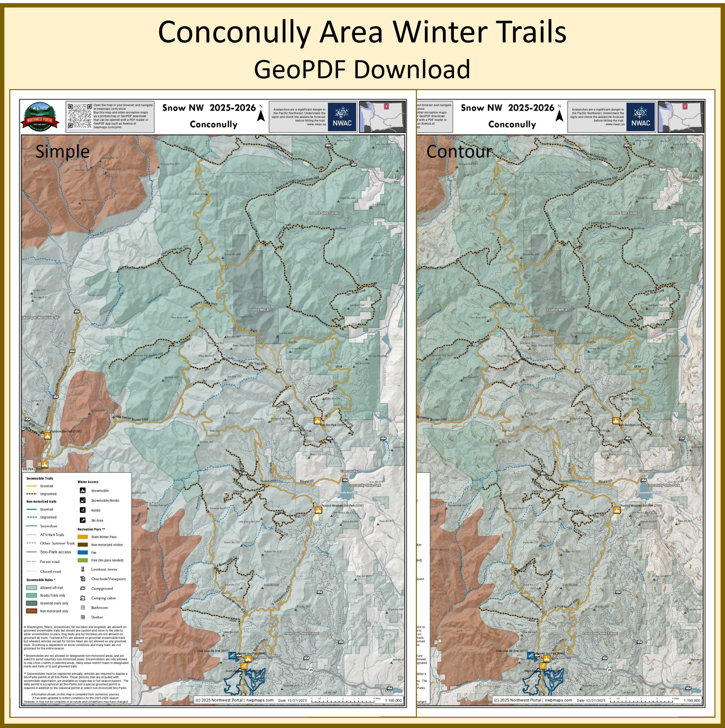
This map of winter trails in the Conconully area of Okanogan County, Washington is part of a series of winter recreation map that show where you can ride your sled, ski or snowshoe in the Pacific Northwest. See which trails are groomed, what areas snowmobiles are allowed and where they are restricted. The maps, which were updated for the 2025-2026 season, include shelters, campgrounds, viewpoints, fire towers as well as summer trails and recreation roads, that are often utilized for winter recreation, campgrounds. The map is a tabloid sized (11x17”) PDF at a 1:150,000 scale that you can print or use with a GeoPDF app such as Avenza. You will receive two versions of the map, one with contour lines and one without. The map includes trails out of the Kerr, Peacock Meadows, North Summit, and North Summit Sno-Parks and trailheads.
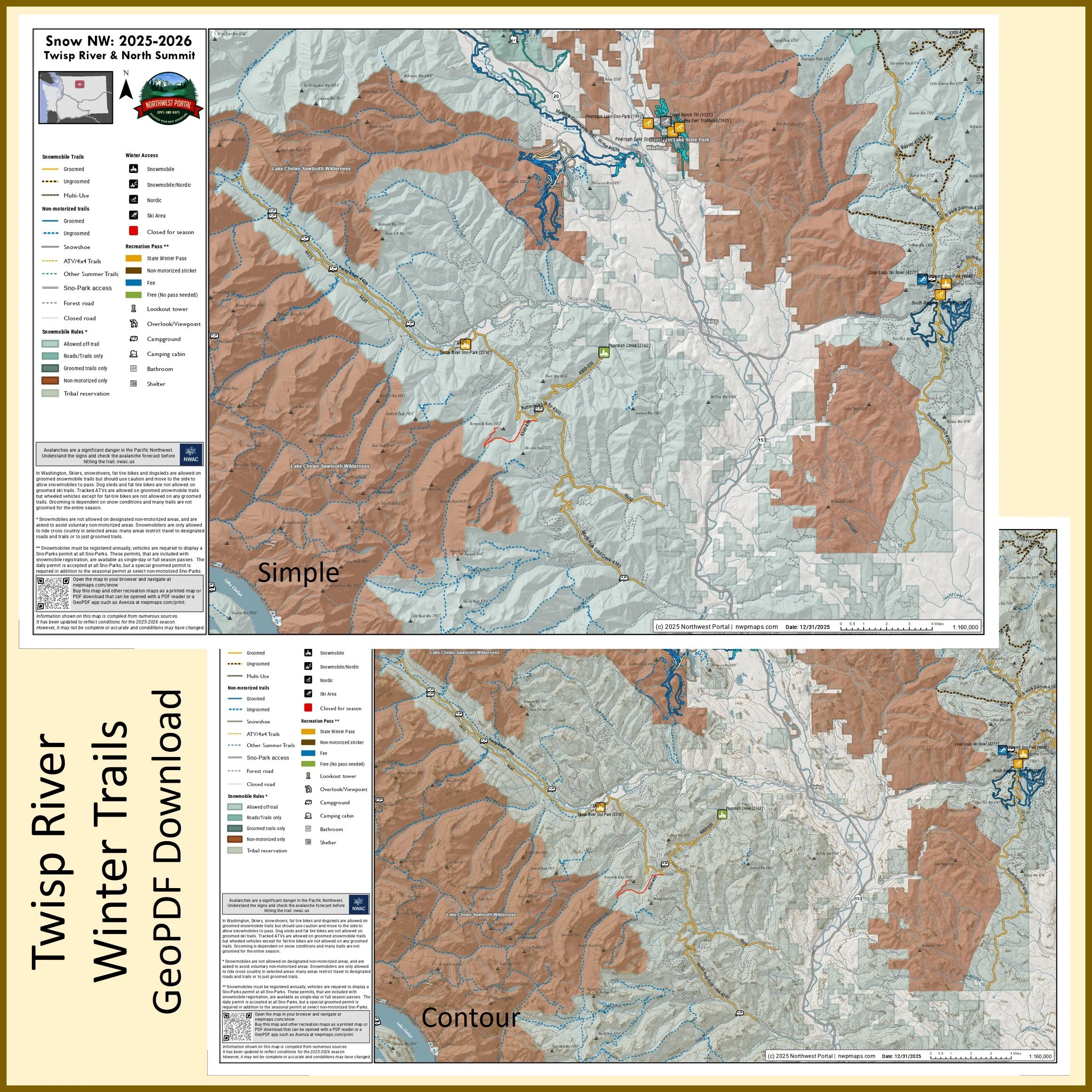
This map of snowmobile trails in the Twisp River and Summit area of Okanogan County, Washington is part of a series of winter recreation map that show where you can ride your sled, ski or snowshoe in the Pacific Northwest. See which trails are groomed, what areas snowmobiles are allowed and where they are restricted. The maps, which were updated for the 2025-2026 season, include shelters, campgrounds, viewpoints, fire towers as well as summer trails and recreation roads, that are often utilized for winter recreation, campgrounds. The map is a tabloid sized (11x17”) PDF at a 1:100,000 scale that you can print or use with a GeoPDF app such as Avenza. You will receive two versions of the map, one with contour lines and one without. The map includes trails out of the Twisp River and South Summit Sno-Parks
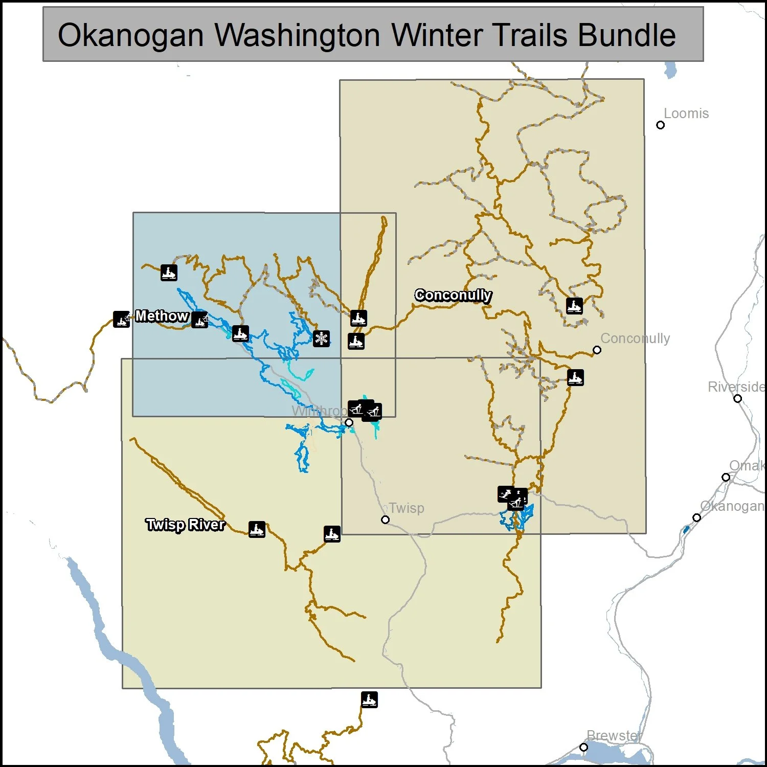
This bundle includes three maps of winter trails in Okanogan County, Washington: Methow (1:100,000), Conconully (1:150,000) and Twisp River (1:100,000).. It is part of a series of winter recreation map that show where you can ride your sled, ski or snowshoe in the Pacific Northwest. See which trails are groomed, what areas snowmobiles are allowed and where they are restricted. The maps, which were updated for the 2025-2026 season, include shelters, campgrounds, viewpoints, fire towers as well as summer trails and recreation roads, that are often utilized for winter recreation, campgrounds. The maps are tabloid sized (11x17”) PDFs that you can print or use with a GeoPDF app such as Avenza. You will receive two versions of each map, one with contour lines and one without.
Poster Size (24x36”)
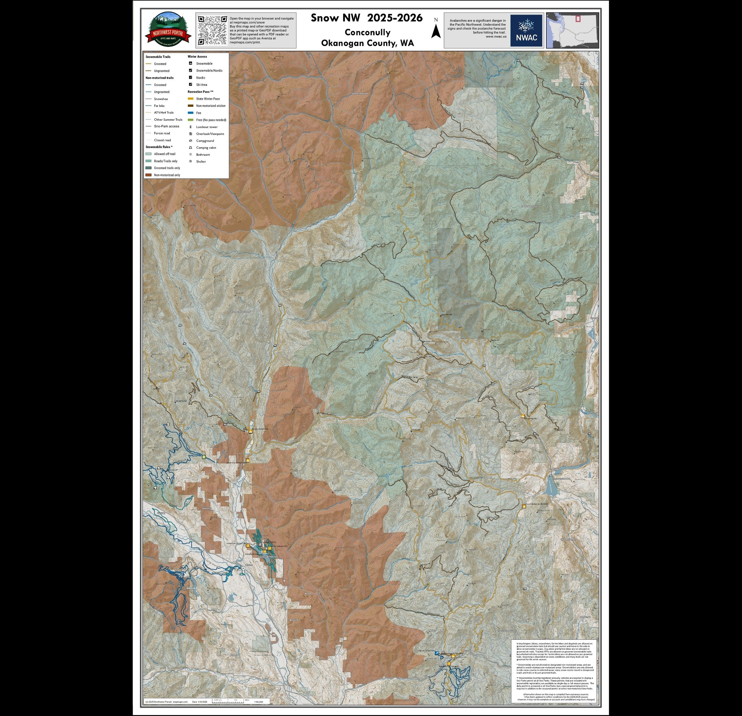
This map of winter trails in the Conconully and Winthrop areas of Okanogan County, Washington is part of a series of winter recreation map that show where you can ride your sled, ski or snowshoe in the Pacific Northwest. See which trails are groomed, what areas snowmobiles are allowed and where they are restricted. The maps, which were updated for the 2025-2026 season, include shelters, campgrounds, viewpoints, fire towers as well as summer trails and recreation roads, that are often utilized for winter recreation, campgrounds. It is a poster sized sized (24x36”) GeoPDF at a 1:80,000 scale that you can print, view in your browser or use with a GeoPDF app such as Avenza The map includes Conconully area groomed trails and identified ungroomed routes out of the Kerr, Peacock Meadows and Summit Sno-Parks and the Methow area snowmobile trails out of Boulder Creek and Eight Mile Sno-Park. In addition, the map shows the Loup Loup Nordic Trails.
Eastern Washington
Stevens & Pend Oreille Counties/Northeast & Umatilla National Forest/Southeast
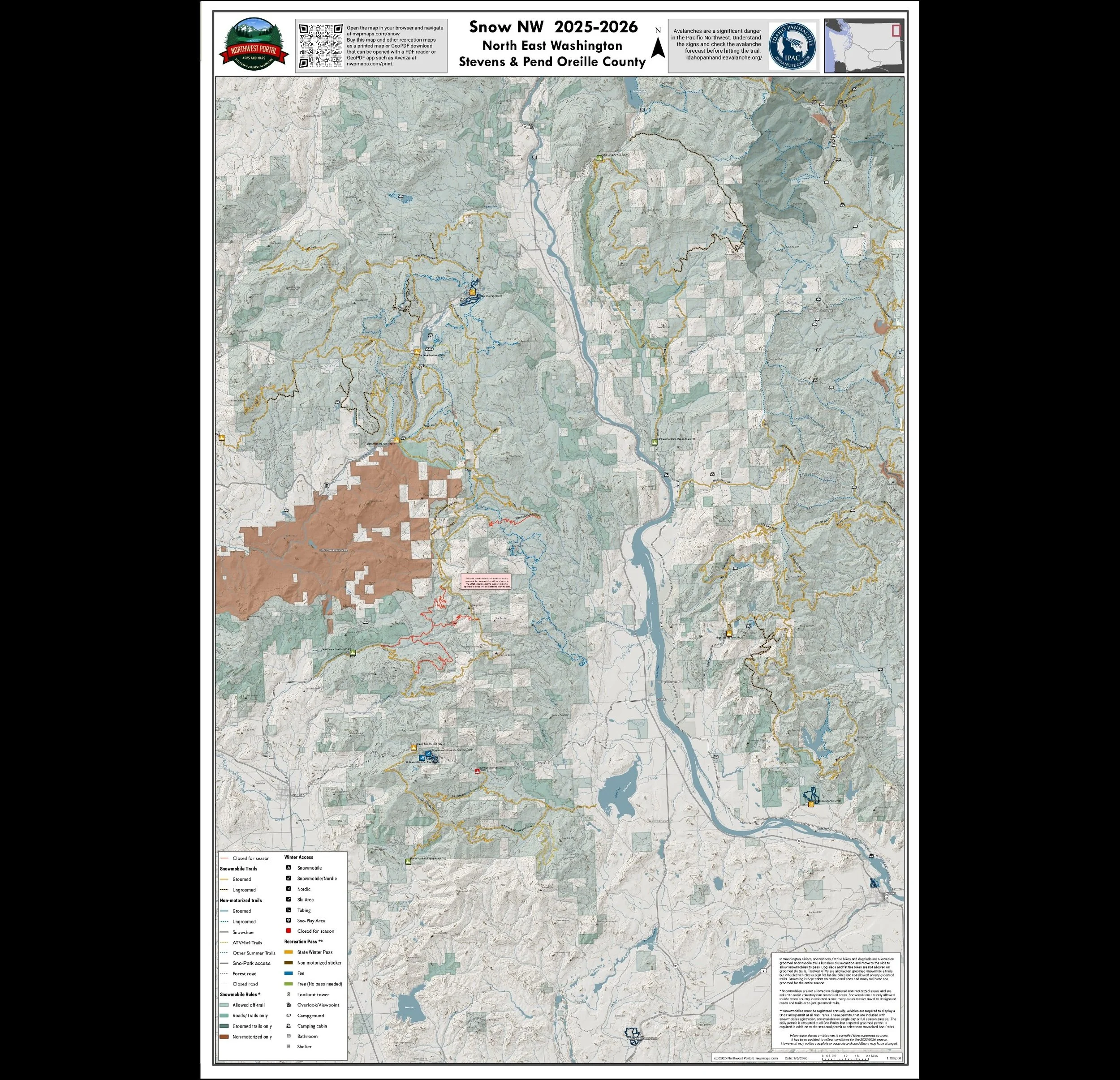
This map of winter trails in Stevens and Pend Oreille Counties, Northeast Washington, is part of a series of winter recreation map that show where you can snowmobile, ski or snowshoe in the Pacific Northwest. See which trails are groomed, what areas snowmobiles are allowed and where they are restricted. The maps, which were updated for the 2025-2026 season, include shelters, campgrounds, viewpoints, fire towers as well as summer trails and recreation roads, that are often utilized for winter recreation, campgrounds. It is a poster sized sized (24x36”) GeoPDF at a 1:100,000 scale that you can print, view in your browser or use with a GeoPDF app such as Avenza. The map includes the trail systems out of Mill Creek/Radar Dome and Flower Trail in Stevens County and trails out of the Hanna Flats and Kings Lake Sno-Parks and Pupal/Le Clerc Creek area trails in Pend Oreille County.
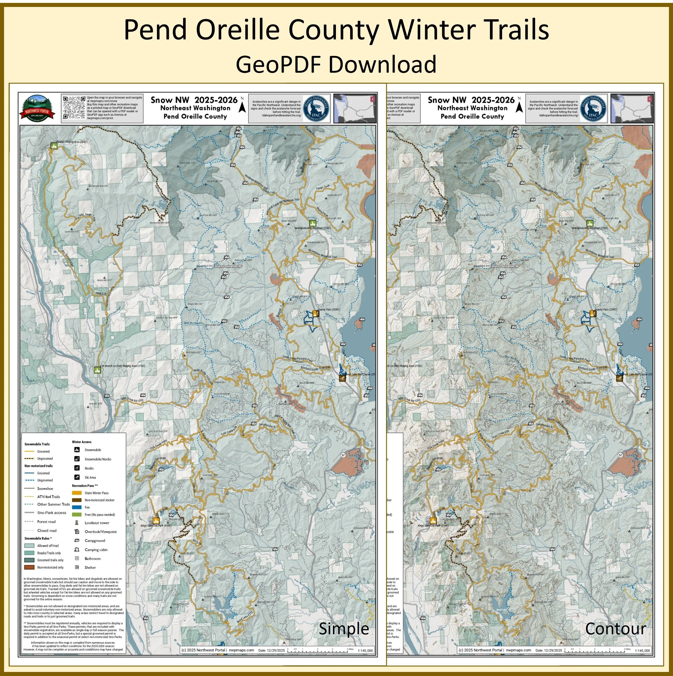
This map of winter trails in Pend Oreille County, Northeast Washington, is part of a series of winter recreation map that show where you can ride your sled, ski or snowshoe in the Pacific Northwest. See which trails are groomed, what areas snowmobiles are allowed and where they are restricted. The maps, which were updated for the 2025-2026 season, include shelters, campgrounds, viewpoints, fire towers as well as summer trails and recreation roads, that are often utilized for winter recreation, campgrounds. The map is a tabloid sized (11x17”) PDF at a 1:145,000 scale that you can print or use with a GeoPDF app such as Avenza. You will receive two versions of the map, one with contour lines and one without. The map includes trails out of the Hanna Flats and Kings Lake Sno-Parks and trailheads.
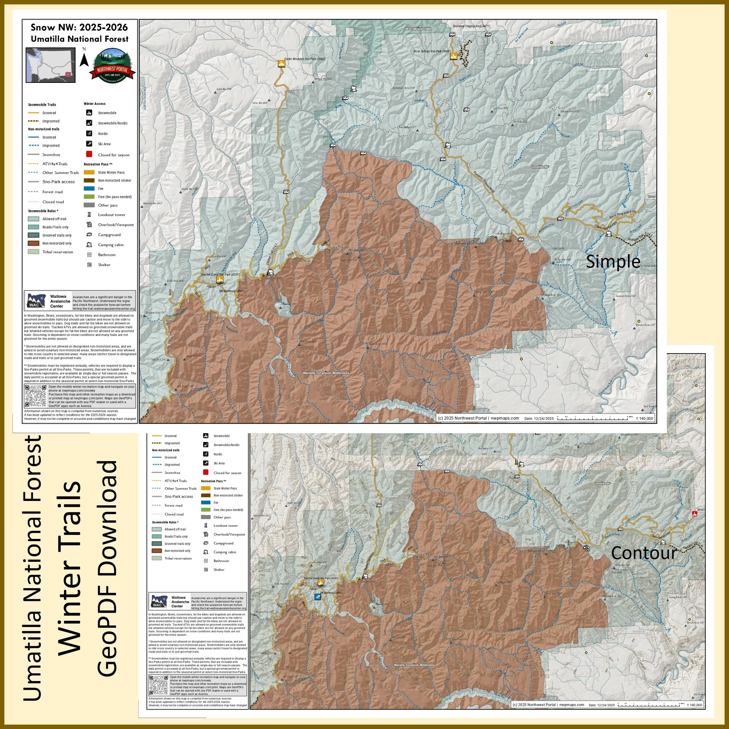
This map of winter trails in Umatilla National Forest in Southeast Washington State is part of a series of winter recreation map that show where you can ride your sled, ski or snowshoe in the Pacific Northwest. See which trails are groomed, what areas snowmobiles are allowed and where they are restricted. The maps, which were updated for the 2025-2026 season, include shelters, campgrounds, viewpoints, fire towers as well as summer trails and recreation roads, that are often utilized for winter recreation, campgrounds. The map is a tabloid sized (11x17”) PDF at a 1:140,000 scale that you can print or use with a GeoPDF app such as Avenza. You will receive two versions of the map, one with contour lines and one without. The map includes trails out of the Eckler Mountain, Rose Springs, and Touchet Corral Sno-Parks and trailheads.
Snow NW - Oregon
Your source for all of the information you need to plan and navigate your next winter adventure. Snowmobile, Nordic and Fat Bike trails in Washington, Idaho and Oregon.
Use the web map that you can access from any browser or buy a GeoPDF map that you can print or use to navigate off-line.
More than 15,000 miles of winter trails and 400+ trailheads, Sno-Parks, and winter recreation facilities in Washington, Idaho, and Oregon. Snowmobiling | Tracked ATVs | Nordic & Alpine Skiing | Snowshoeing | Snowboarding | Sledding | Fat Tire Biking | Dog Sledding
North Oregon Cascades
Hood River, Mount Hood and North Santiam
Tabloid Size (11x17”)
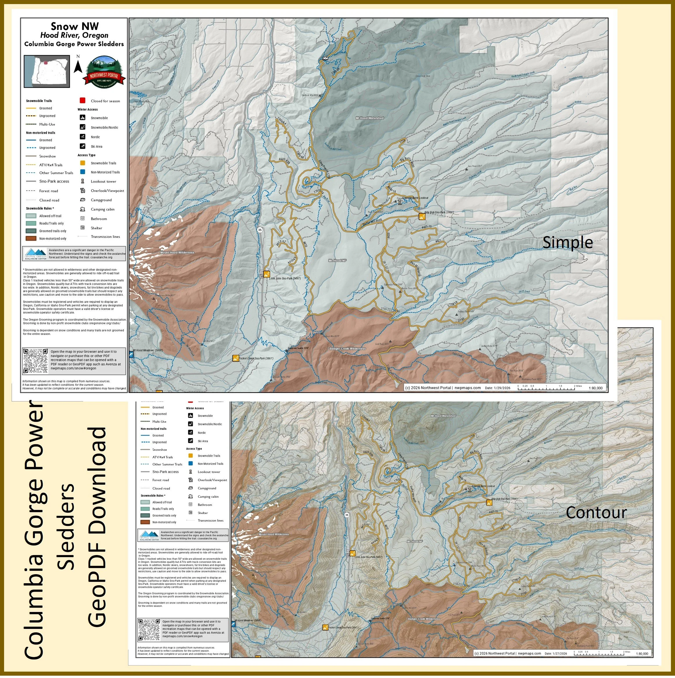
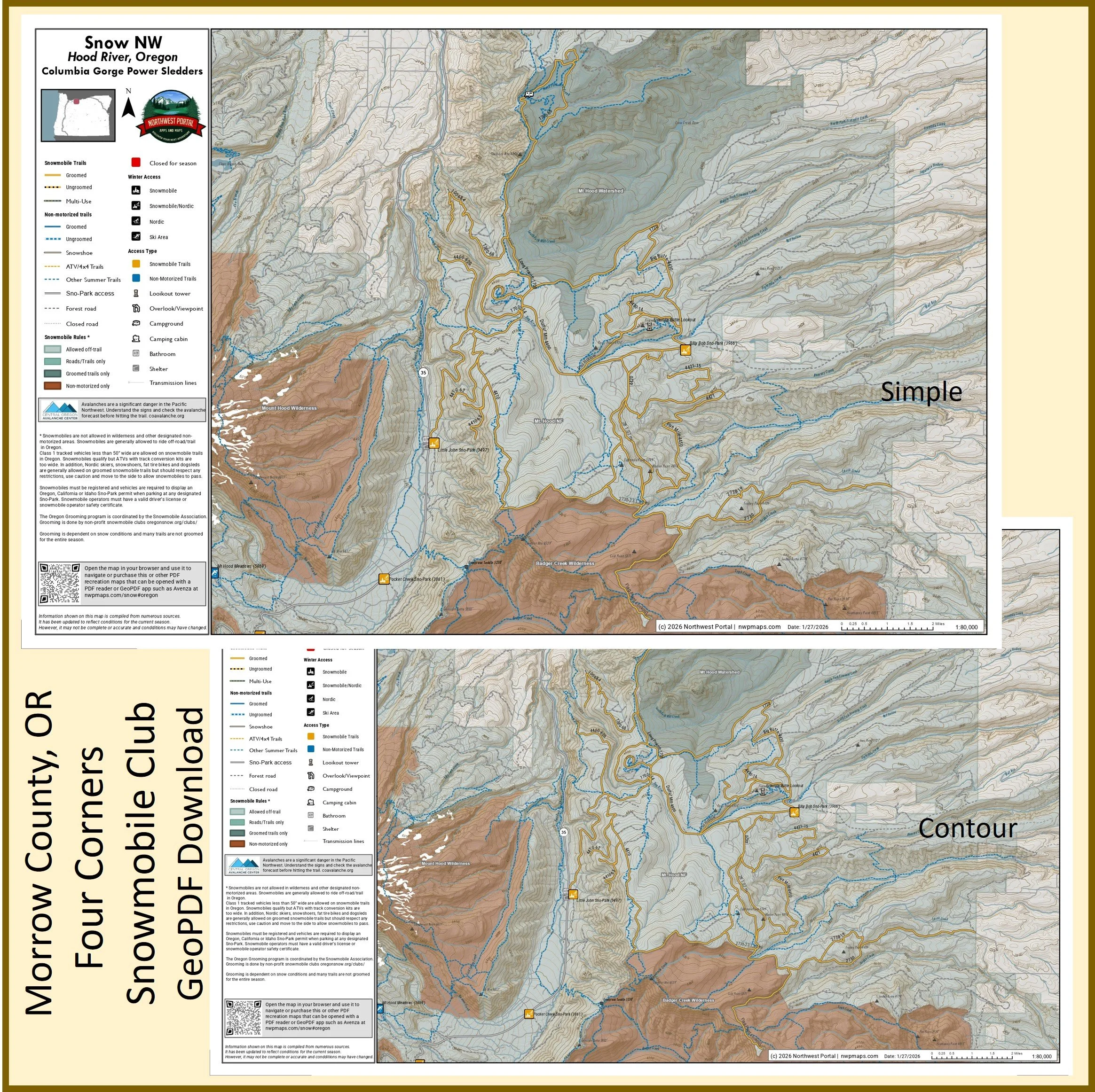
This map of winter trails in Oregon's Mt Hood National Forest that are groomed by the Columbia Gorge Power Sledders is part of a series of winter recreation map that show where you can ride your sled, ski or snowshoe in the Pacific Northwest. See which trails are groomed, what areas snowmobiles are allowed and where they are restricted. The maps, which were updated for the 2025-2026 season, include shelters, campgrounds, viewpoints, fire towers as well as summer trails and recreation roads, that are often utilized for winter recreation. It includes trails out of the Billy Bob, Little John and Pocket Creek Sno-Parks in Hood River and Wasco Counties. The map is a tabloid sized (11x17”) PDF at a 1:80,000 scale that you can print or use with a GeoPDF app such as Avenza. You will receive two versions of the map, one with contour lines and one without.
This map of winter trails in Oregon's Williamette that are groomed by the North Santiam Snowmobile Club is part of a series of winter recreation map that show where you can ride your sled, ski or snowshoe in the Pacific Northwest. See which trails are groomed, what areas snowmobiles are allowed and where they are restricted. The maps, which were updated for the 2025-2026 season, include shelters, campgrounds, viewpoints, fire towers as well as summer trails and recreation roads, that are often utilized for winter recreation. It includes trails out of the McCoy Sno-Parks in Marion County. The map is a tabloid sized (11x17”) PDF at a 1:40,000 scale that you can print or use with a GeoPDF app such as Avenza. You will receive two versions of the map, one with contour lines and one without.
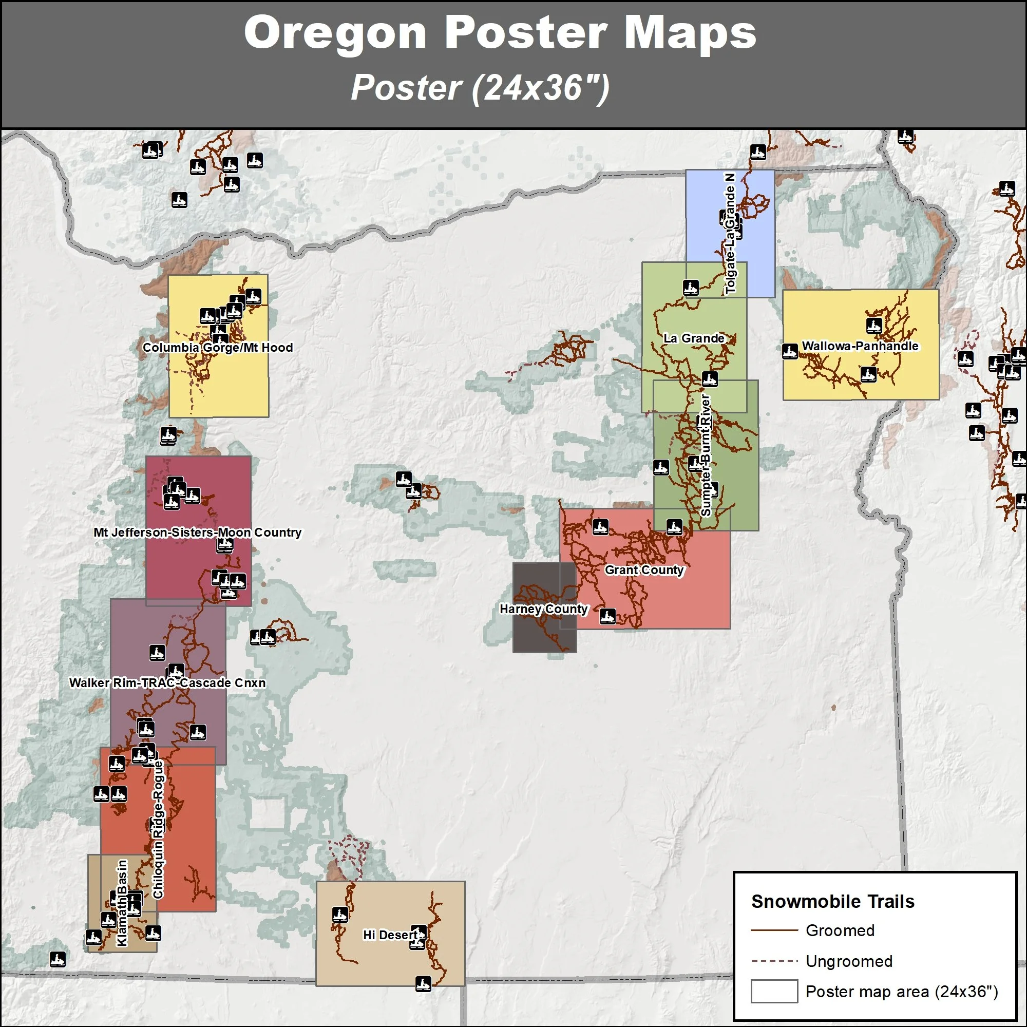
Poster (24x36”)
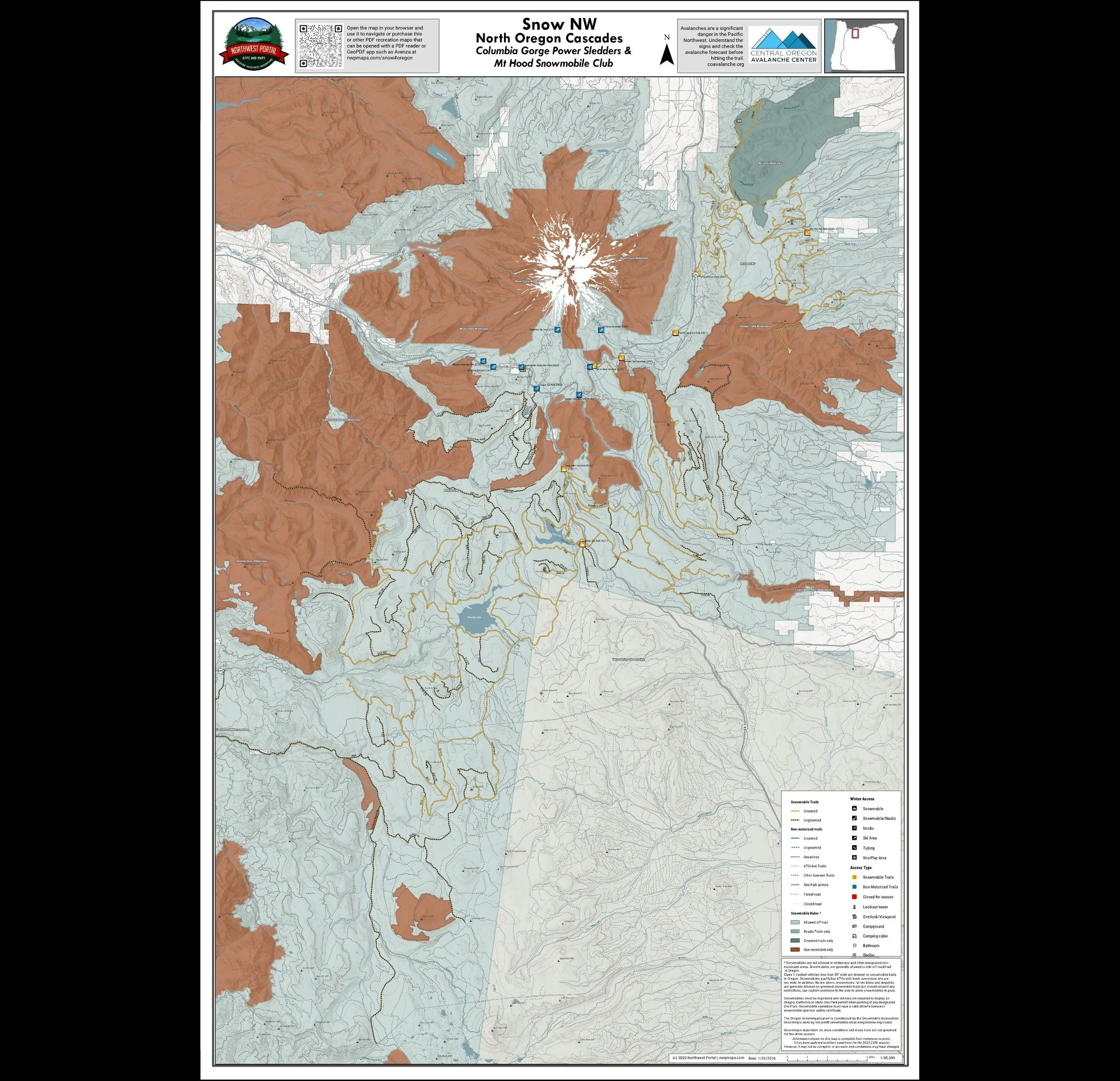
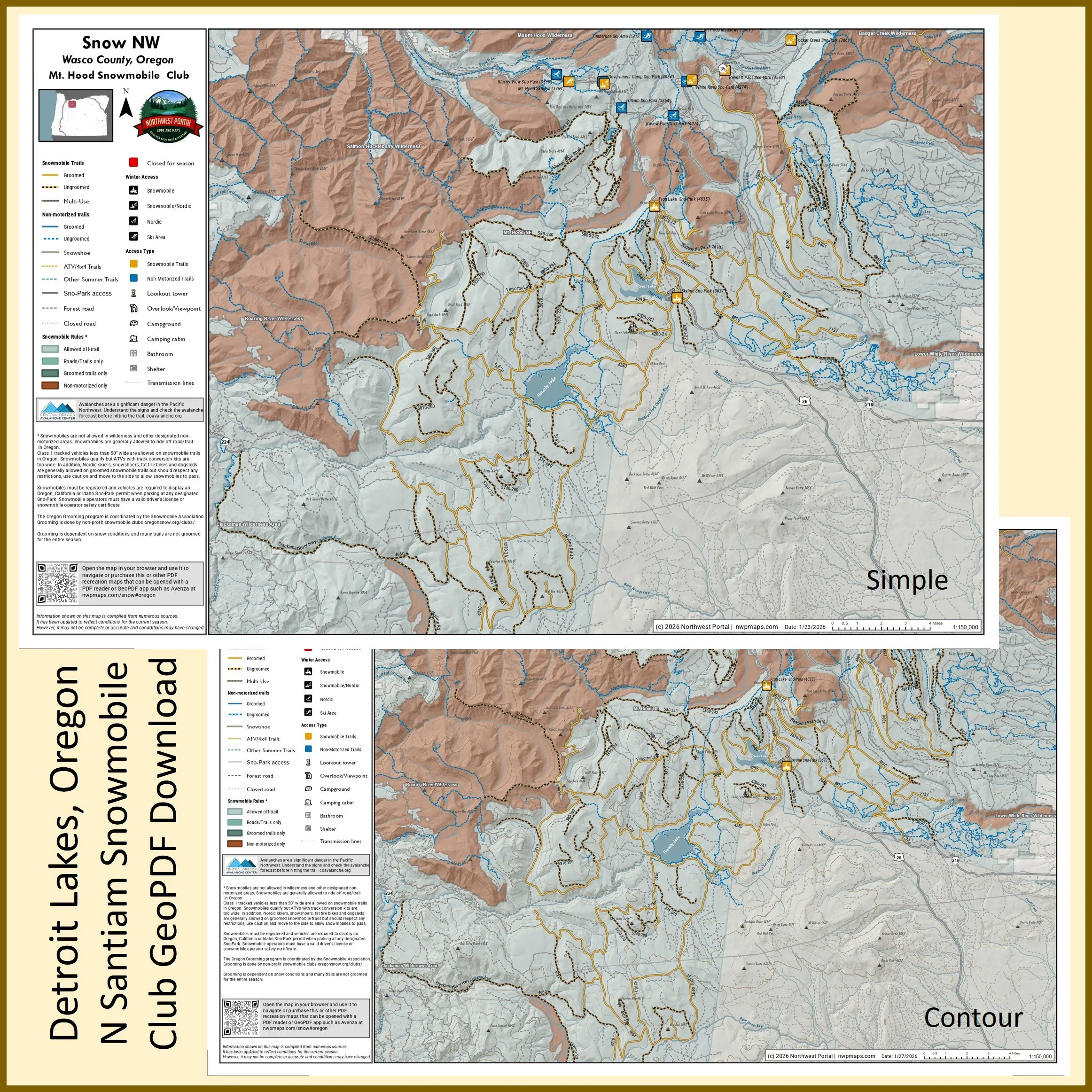
This map shows winter trails in Oregon’s North Cascades that are groomed by Columbia Gorge Power Sledders & Mt Hood Snowmobile Club. It is part of a series of winter recreation map that show where you can ride your sled, ski or snowshoe in the Pacific Northwest. See which trails are groomed, what areas snowmobiles are allowed and where they are restricted. The maps, which were updated for the 2025-2026 season, include shelters, campgrounds, viewpoints, fire towers as well as summer trails and recreation roads, that are often utilized for winter recreation. This map shows trails served by the Billy Bob, Little John, Pocket Creek, White River, Pocket Creek, Frog Lake, and Skyline Sno-Parks. The map includes areas in the Mt Hood National Forests in Hood River, Clackamas and Wasco Counties. It is a poster sized (24x36”) PDF at a 1:95,000 scale that you can print or use with a GeoPDF app such as Avenza.
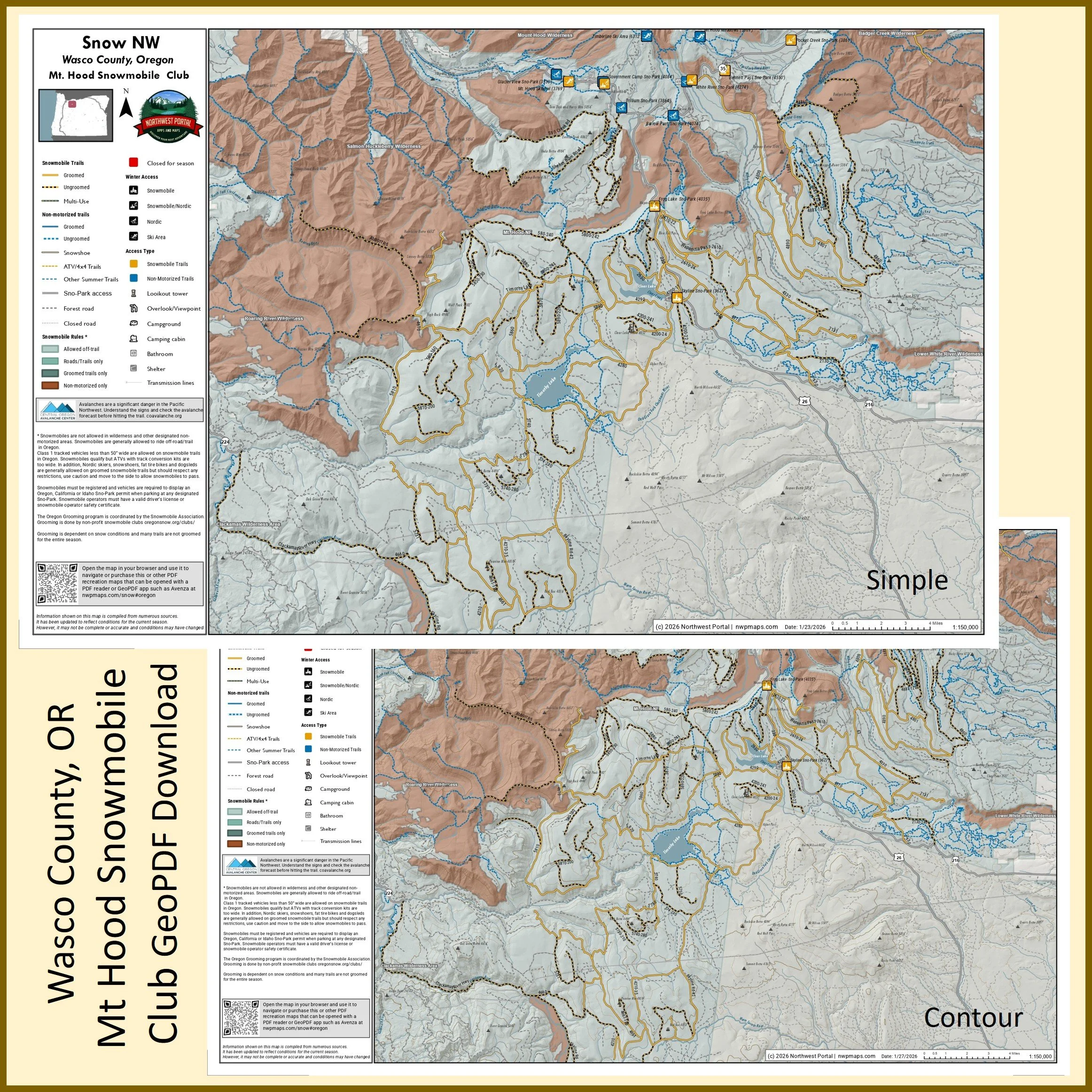
This map of winter trails in Oregon's Mt.Hood National Forest that are groomed by the Mt.Hood Snowmobile Club is part of a series of winter recreation map that show where you can ride your sled, ski or snowshoe in the Pacific Northwest. See which trails are groomed, what areas snowmobiles are allowed and where they are restricted. The maps, which were updated for the 2025-2026 season, include shelters, campgrounds, viewpoints, fire towers as well as summer trails and recreation roads, that are often utilized for winter recreation. It includes trails out of the White River, Pocket Creek, Frog Lake, and Skyline Sno-Parks in Clakamas and Wasco Counties. The map is a tabloid sized (11x17”) PDF at a 1:150,000 scale that you can print or use with a GeoPDF app such as Avenza. You will receive two versions of the map, one with contour lines and one without.
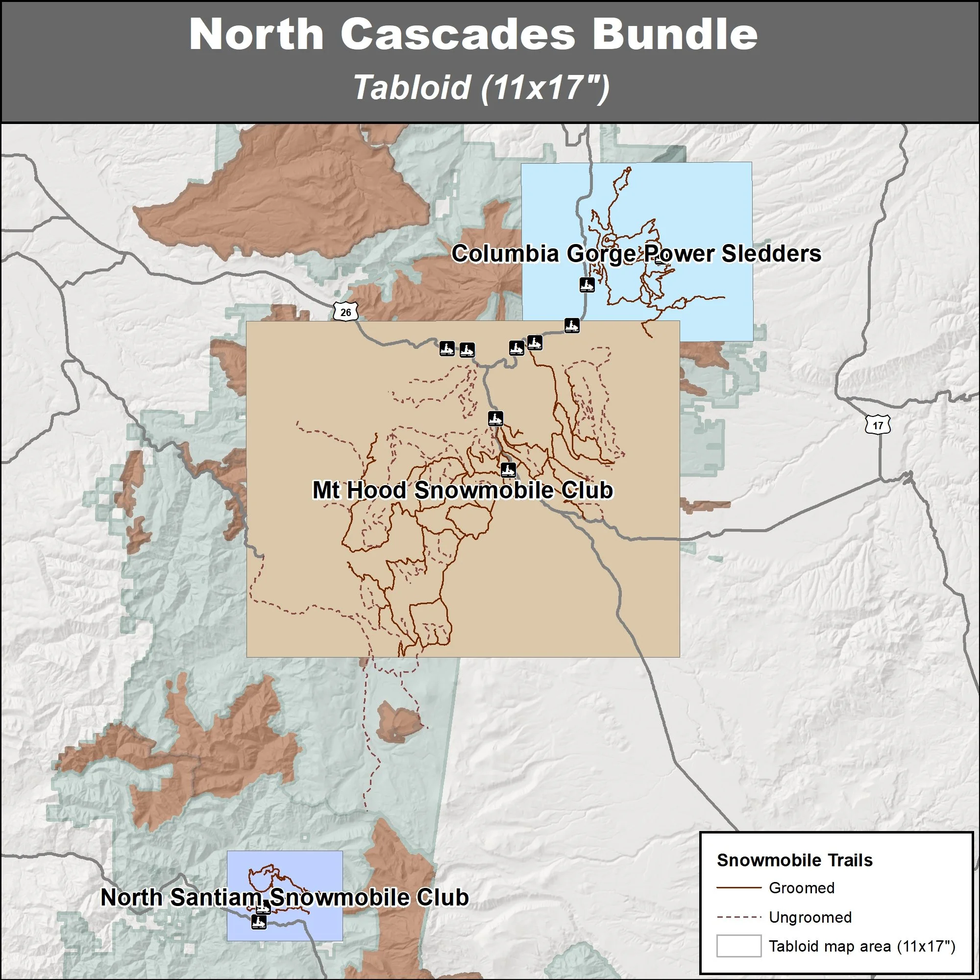
This bundle contains three maps of snowmobile trails in Oregon’s North Cascades: areas groomed by the Columbia Gorge Power Sledders, Mt Hood Snowmobile Club and North Santiam Snowmobile Club. These maps are part of a series of winter recreation map that show where you can ride your sled, ski or snowshoe in the Pacific Northwest. See which trails are groomed, what areas snowmobiles are allowed and where they are restricted. The maps, which were updated for the 2025-2026 season, include shelters, campgrounds, viewpoints, fire towers as well as summer trails and recreation roads, that are often utilized for winter recreation. You will receive two versions of each area, one with contour lines and one without.
Central Oregon Cascades
Willamette National Forest, Deschutes National Forest, & Umpqua National Forest
Mt Jefferson Snowmobile Club, Sister’s Go-Fers, Moon Country Snow Busters, La Pine Lodgepole Dodgers, Walker Rim Riders, Cascade Connection and Two Rivers Activity Club
Tabloid Size (11x17”)
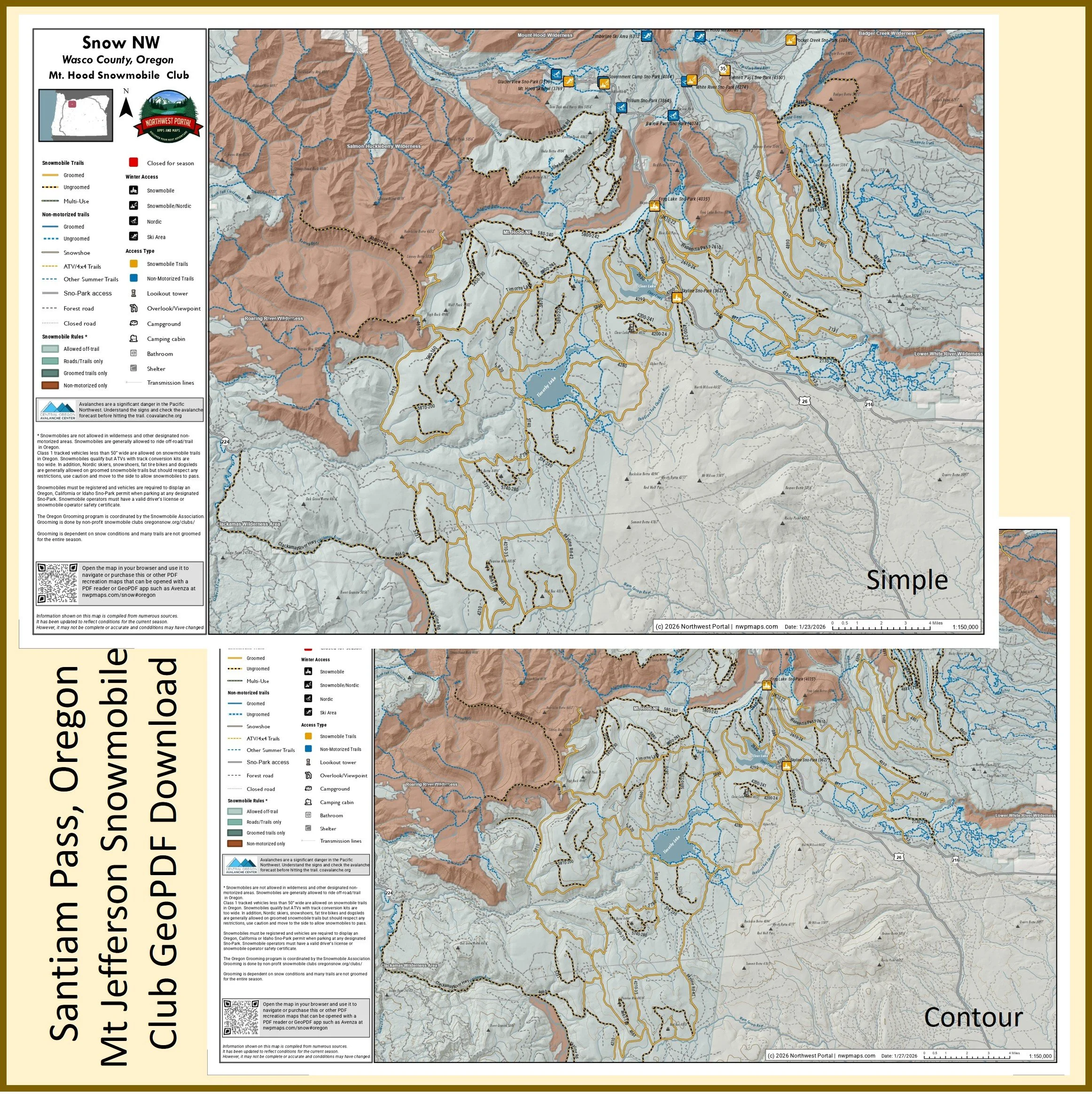
This map of winter trails in the Santia Pass area of Oregon's Willamette and Deschutes National Forests that are groomed by the Mt.Jefferson Snowmobile Club is part of a series of winter recreation map that show where you can ride your sled, ski or snowshoe in the Pacific Northwest. See which trails are groomed, what areas snowmobiles are allowed and where they are restricted. The maps, which were updated for the 2025-2026 season, include shelters, campgrounds, viewpoints, fire towers as well as summer trails and recreation roads, that are often utilized for winter recreation. It includes trails out of the Big Springs, Lava Lake, Little Nash, Ray Benson, Ikenick Sno-Parks in Lane and Deschutes counties. The map is a tabloid sized (11x17”) PDF at a 1:110,000 scale that you can print or use with a GeoPDF app such as Avenza. You will receive two versions of the map, one with contour lines and one without.
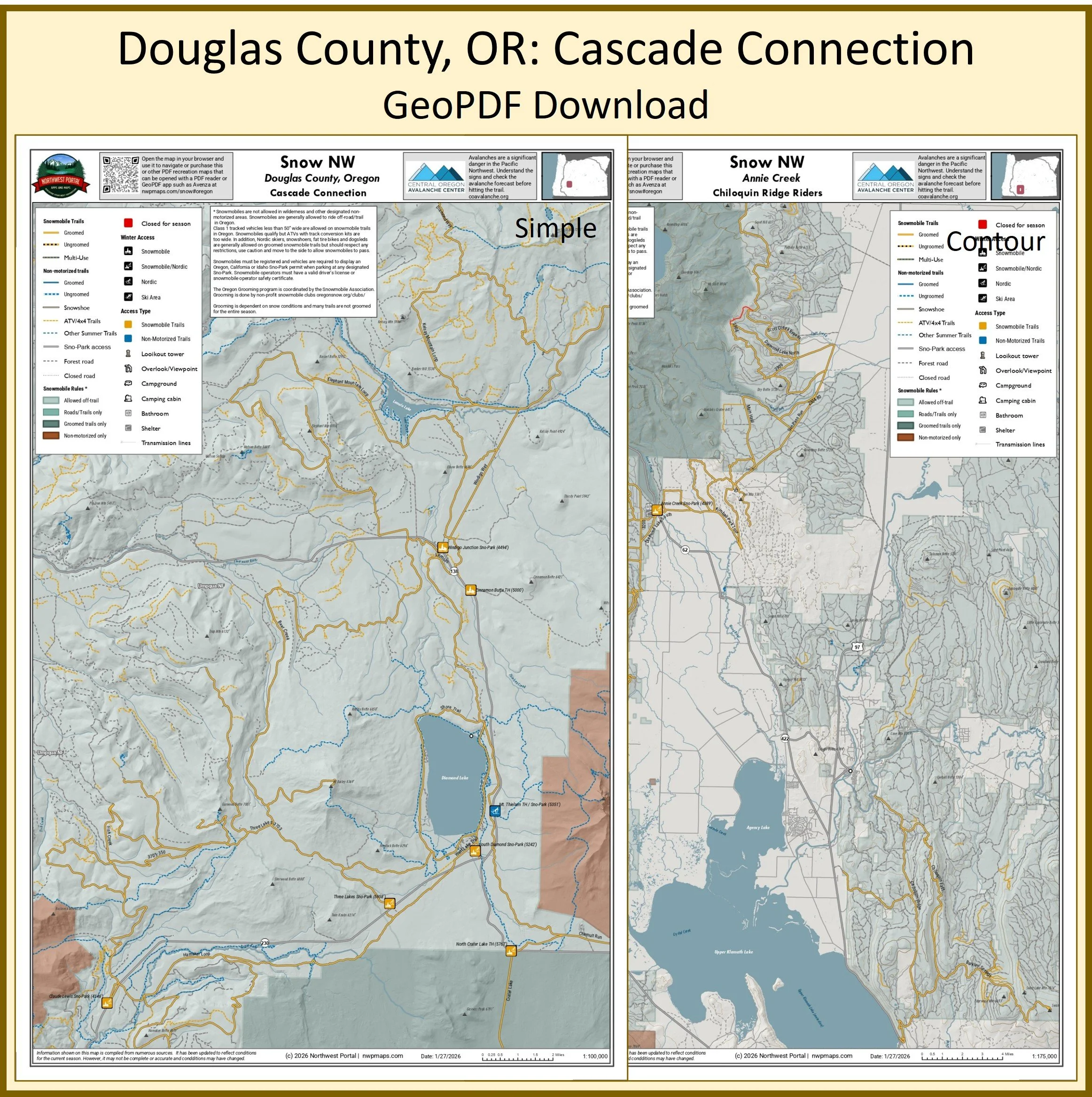
This map of winter trails in Oregon's Umpqua National Forest that are groomed by Cascade Connection is part of a series of winter recreation map that show where you can ride your sled, ski or snowshoe in the Pacific Northwest. See which trails are groomed, what areas snowmobiles are allowed and where they are restricted. The maps, which were updated for the 2025-2026 season, include shelters, campgrounds, viewpoints, fire towers as well as summer trails and recreation roads, that are often utilized for winter recreation. It includes trails out of the Claude Lewis, Windigo Junction, Cinnamon Butte, South Diamond, Three Lake, and North Crater Lake Sno-Parks in Douglas County. The map is a tabloid sized (11x17”) PDF at a 1:100,000 scale that you can print or use with a GeoPDF app such as Avenza. You will receive two versions of the map, one with contour lines and one without.
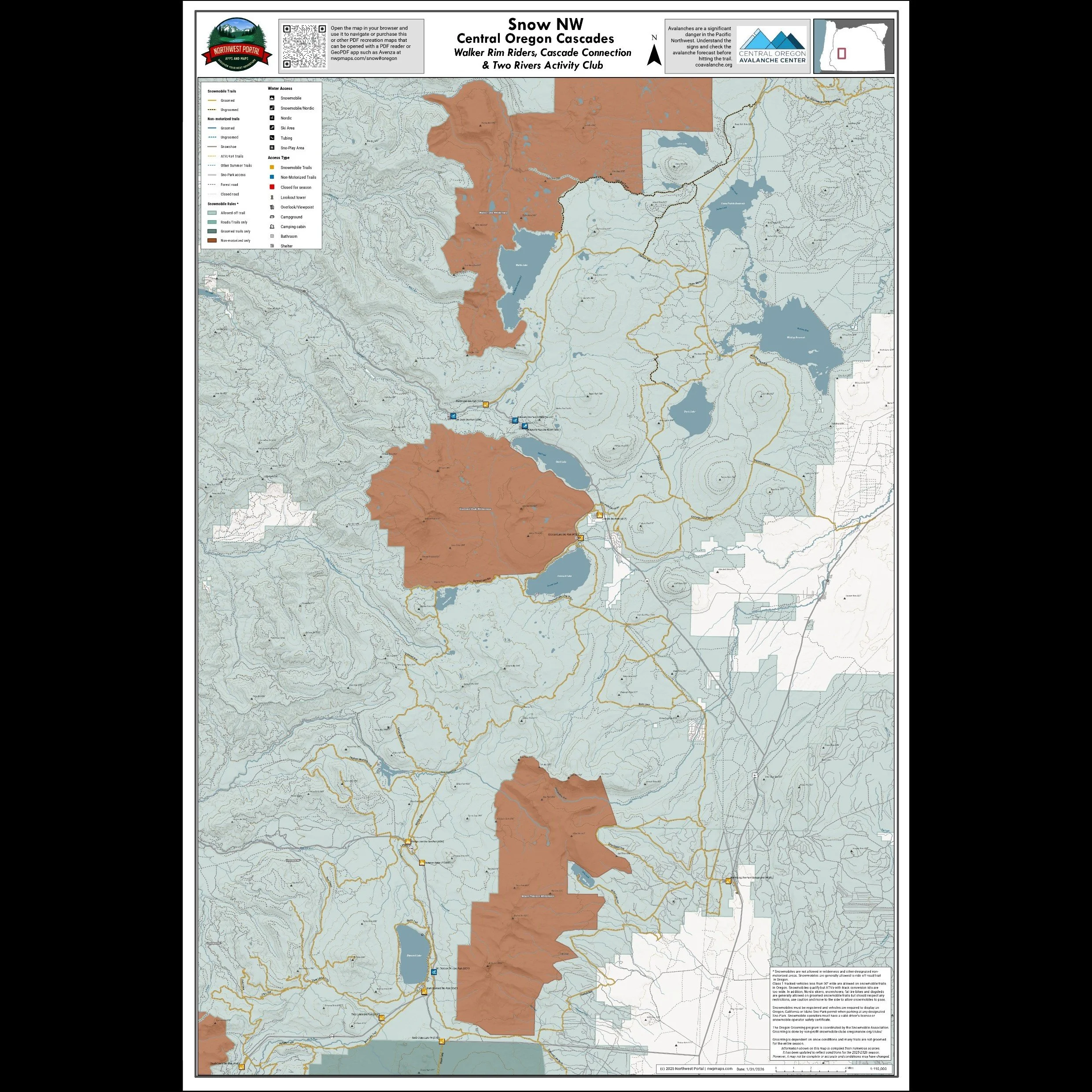
This map shows winter trails in Oregon’s Central Cascades that are groomed by the Walker Rim Riders, Cascade Connection & Two Rivers Activity Club snowmobile clubs. It is part of a series of winter recreation map that show where you can ride your sled, ski or snowshoe in the Pacific Northwest. See which trails are groomed, what areas snowmobiles are allowed and where they are restricted. The maps, which were updated for the 2025-2026 season, include shelters, campgrounds, viewpoints, fire towers as well as summer trails and recreation roads, that are often utilized for winter recreation. This map shows trails served by Claude Lewis, Windigo Junction, Cinnamon Butte, South Diamond, Three Lake, and North Crater Lake Annie Creek, Great Meadow and Lake of the Woods Sno-Parks. The map includes areas in the Umpqua, Willamette, Fremont-Wienma and Deschutes National Forests in Deschutes, Klamath and Douglas Counties. It is a poster sized (24x36”) PDF at a 1:110,000 scale that you can print or use with a GeoPDF app such as Avenza.
This map of winter trails in Oregon's Deschutes National Forest that are groomed by the Moon County Snowbusters is part of a series of winter recreation map that show where you can ride your sled, ski or snowshoe in the Pacific Northwest. See which trails are groomed, what areas snowmobiles are allowed and where they are restricted. The maps, which were updated for the 2025-2026 season, include shelters, campgrounds, viewpoints, fire towers as well as summer trails and recreation roads, that are often utilized for winter recreation. It includes trails out of the Dutchman, Kapla,Edison Butte, and Wanoga Sno Parks in Deschutes County. The map is a tabloid sized (11x17”) PDF at a 1:85,000 scale that you can print or use with a GeoPDF app such as Avenza. You will receive two versions of the map, one with contour lines and one without.
This map of winter trails in Oregon's Deschutes National Forest that are groomed by the La Pine Lodgepole Dodgers is part of a series of winter recreation map that show where you can ride your sled, ski or snowshoe in the Pacific Northwest. See which trails are groomed, what areas snowmobiles are allowed and where they are restricted. The maps, which were updated for the 2025-2026 season, include shelters, campgrounds, viewpoints, fire towers as well as summer trails and recreation roads, that are often utilized for winter recreation. It includes trails out of 6 and 10 Mile Sno-Parks in the Newberry/Paulina Lake area of Deschutes County.The map is a tabloid sized (11x17”) PDF at a 1:90,000 scale that you can print or use with a GeoPDF app such as Avenza. You will receive two versions of the map, one with contour lines and one without.
Poster (24x36”)
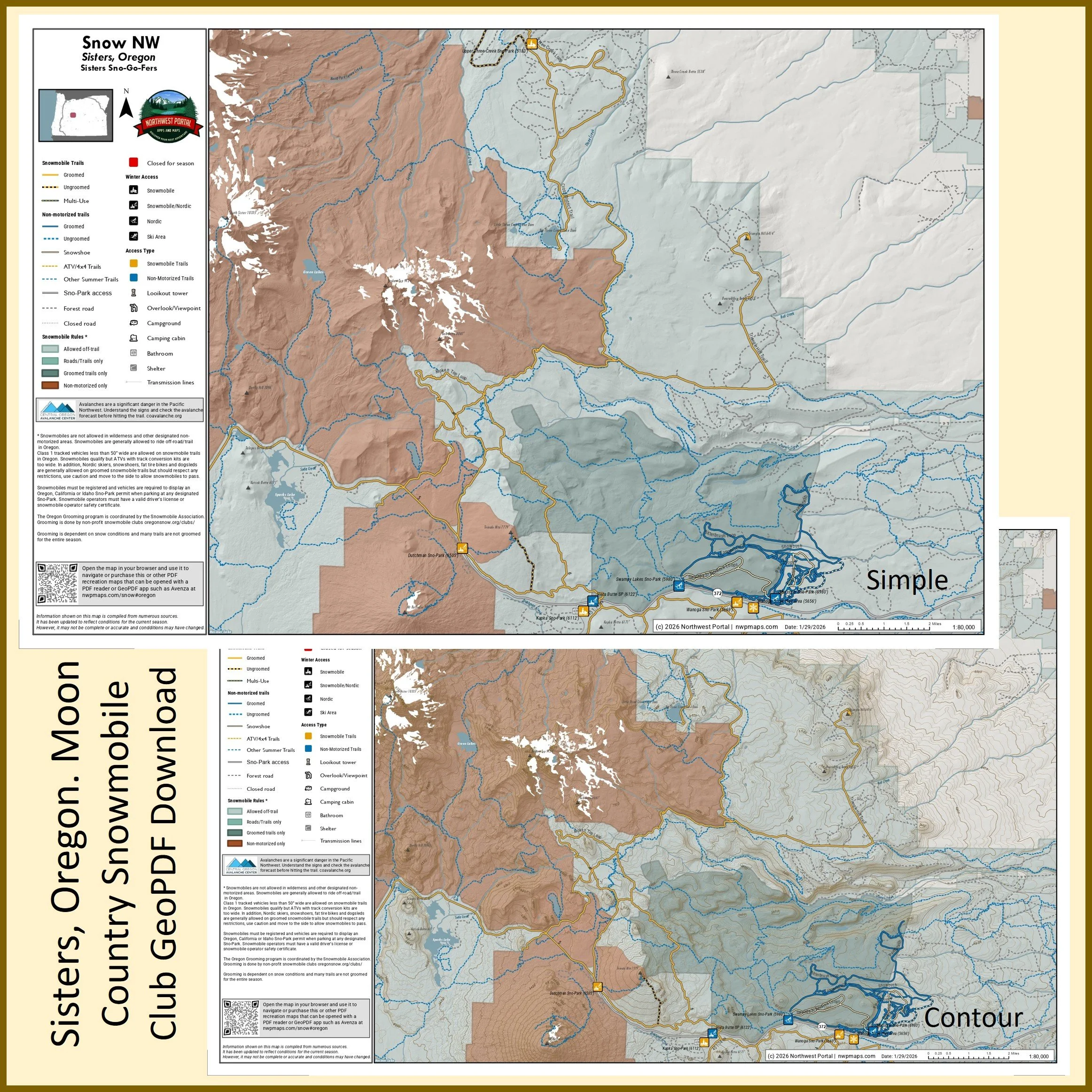
This map of winter trails in Oregon's Deschutes National Forest that are groomed by the Sisters Sno-Go Fers is part of a series of winter recreation map that show where you can ride your sled, ski or snowshoe in the Pacific Northwest. See which trails are groomed, what areas snowmobiles are allowed and where they are restricted. The maps, which were updated for the 2025-2026 season, include shelters, campgrounds, viewpoints, fire towers as well as summer trails and recreation roads, that are often utilized for winter recreation. It includes trails out of the Upper Creek, Dutchman, Kapika, and Wanoga Sno-Parks in Deschutes county. The map is a tabloid sized (11x17”) PDF at a 1:80,000 scale that you can print or use with a GeoPDF app such as Avenza. You will receive two versions of the map, one with contour lines and one without.
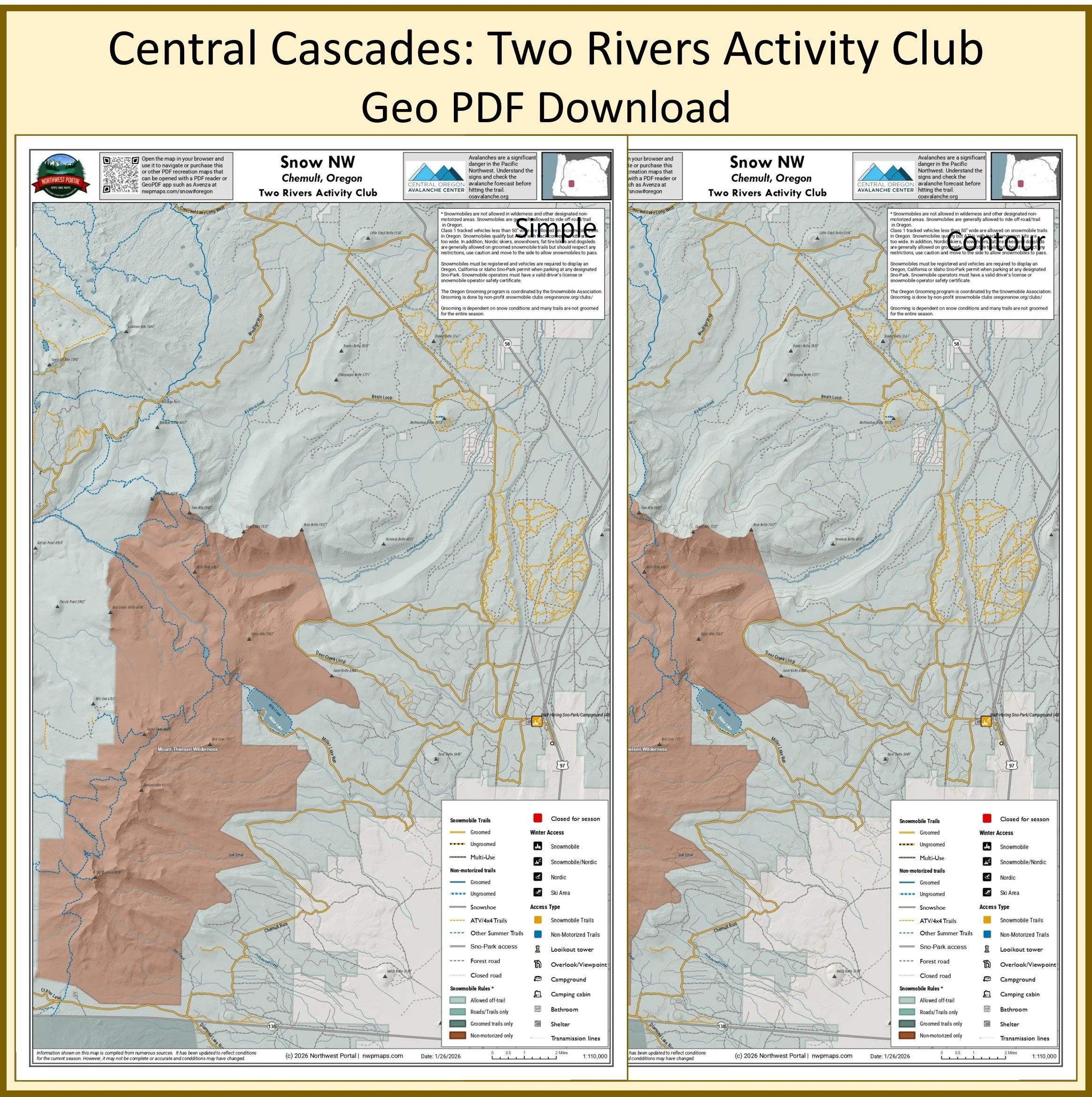
This map of winter trails in Oregon's Deschutes, Fremont-Wienma and Umpqua National Forests that are groomed by the Two River Activity Club is part of a series of winter recreation map that show where you can ride your sled, ski or snowshoe in the Pacific Northwest. See which trails are groomed, what areas snowmobiles are allowed and where they are restricted. The maps, which were updated for the 2025-2026 season, include shelters, campgrounds, viewpoints, fire towers as well as summer trails and recreation roads, that are often utilized for winter recreation. It includes trails out of the Walt Haring Sno-Park in Douglas and Klamath counties. The map is a tabloid sized (11x17”) PDF at a 1:110,000 scale that you can print or use with a GeoPDF app such as Avenza. You will receive two versions of the map, one with contour lines and one without.
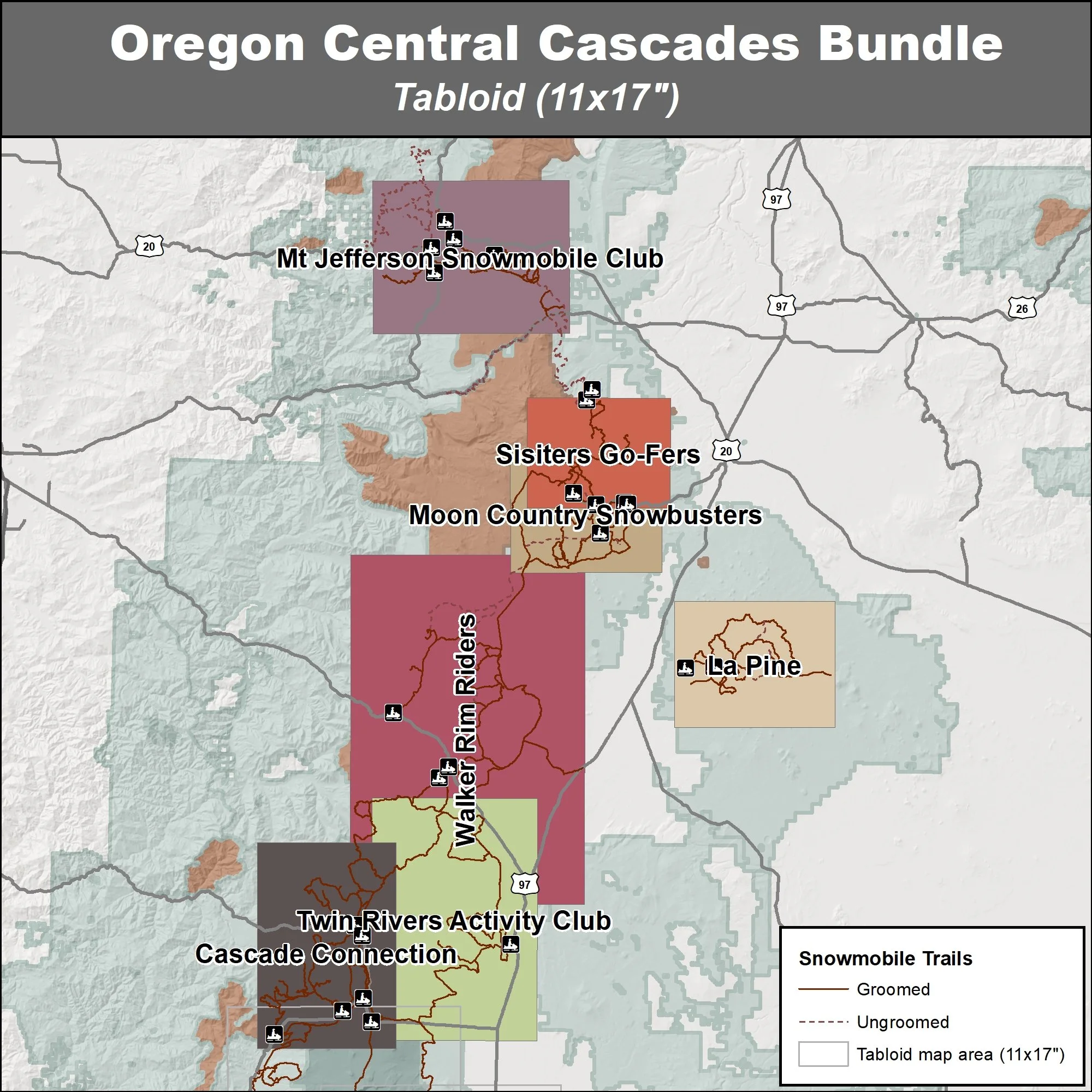
This bundle contains seven maps of snowmobile trails in Oregon’s Central Cascades: areas groomed by the Mt Jefferson Snowmobile Club, Sisters Go-Fers, Moon Country Snowbusters, La Pine La Pine Lodgepole Dodgers, Walker Rim Riders, Twin Rivers Activity Club and Cascade Connection. These maps are part of a series of winter recreation map that show where you can ride your sled, ski or snowshoe in the Pacific Northwest. See which trails are groomed, what areas snowmobiles are allowed and where they are restricted. The maps, which were updated for the 2025-2026 season, include shelters, campgrounds, viewpoints, fire towers as well as summer trails and recreation roads, that are often utilized for winter recreation. You will receive two versions of each area, one with contour lines and one without.
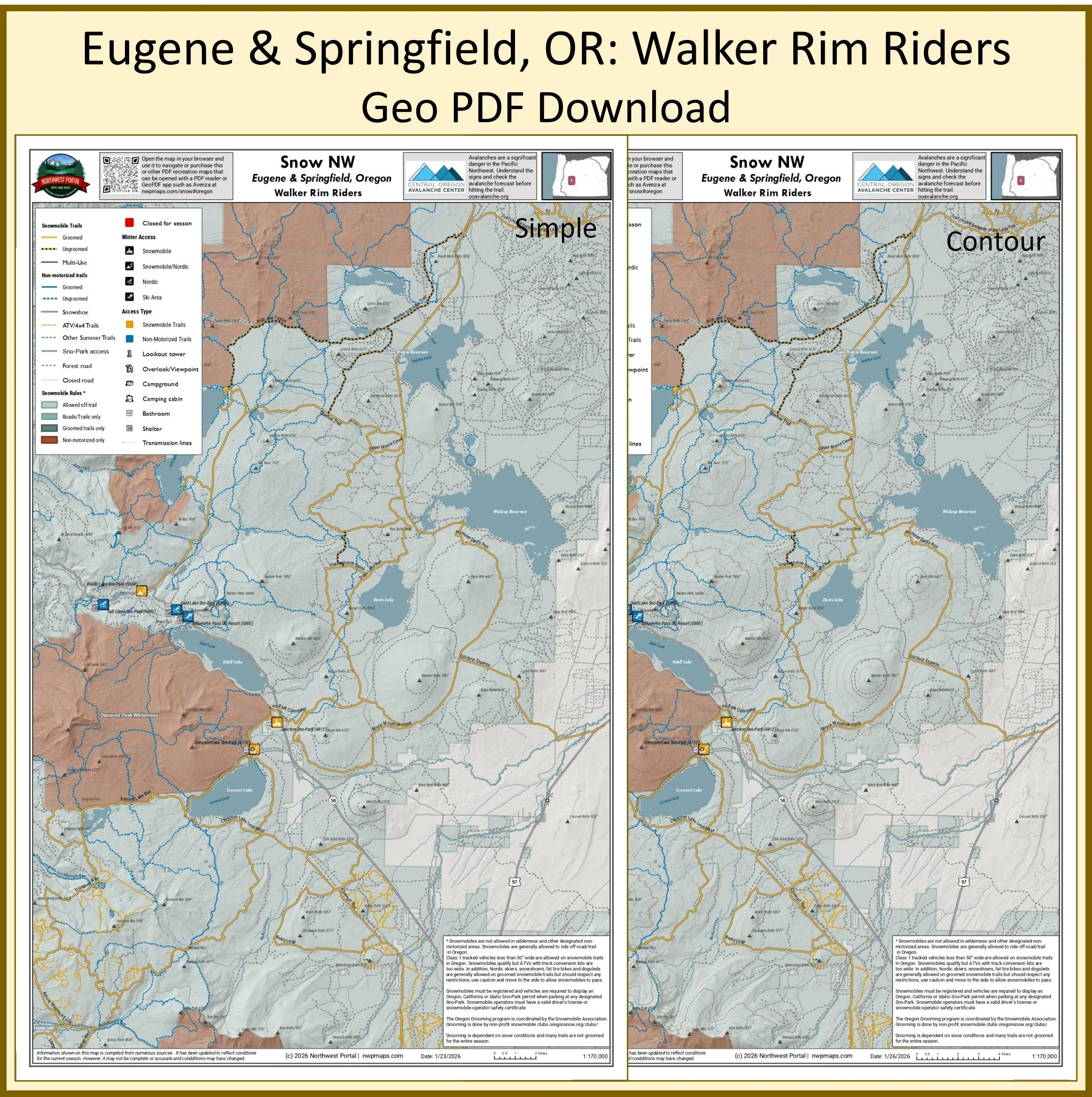
This map of winter trails in Oregon's Willamette and Deschutes National Forest that are groomed by the Walker Rim Riders is part of a series of winter recreation map that show where you can ride your sled, ski or snowshoe in the Pacific Northwest. See which trails are groomed, what areas snowmobiles are allowed and where they are restricted. The maps, which were updated for the 2025-2026 season, include shelters, campgrounds, viewpoints, fire towers as well as summer trails and recreation roads, that are often utilized for winter recreation. It includes trails out of the Annie Creek, Great Meadow, and Lake of the Woods Sno-Park in Lane, Deschutes, and Klamath counties. The map is a tabloid sized (11x17”) PDF at a 175,000 scale that you can print or use with a GeoPDF app such as Avenza. You will receive two versions of the map, one with contour lines and one without.
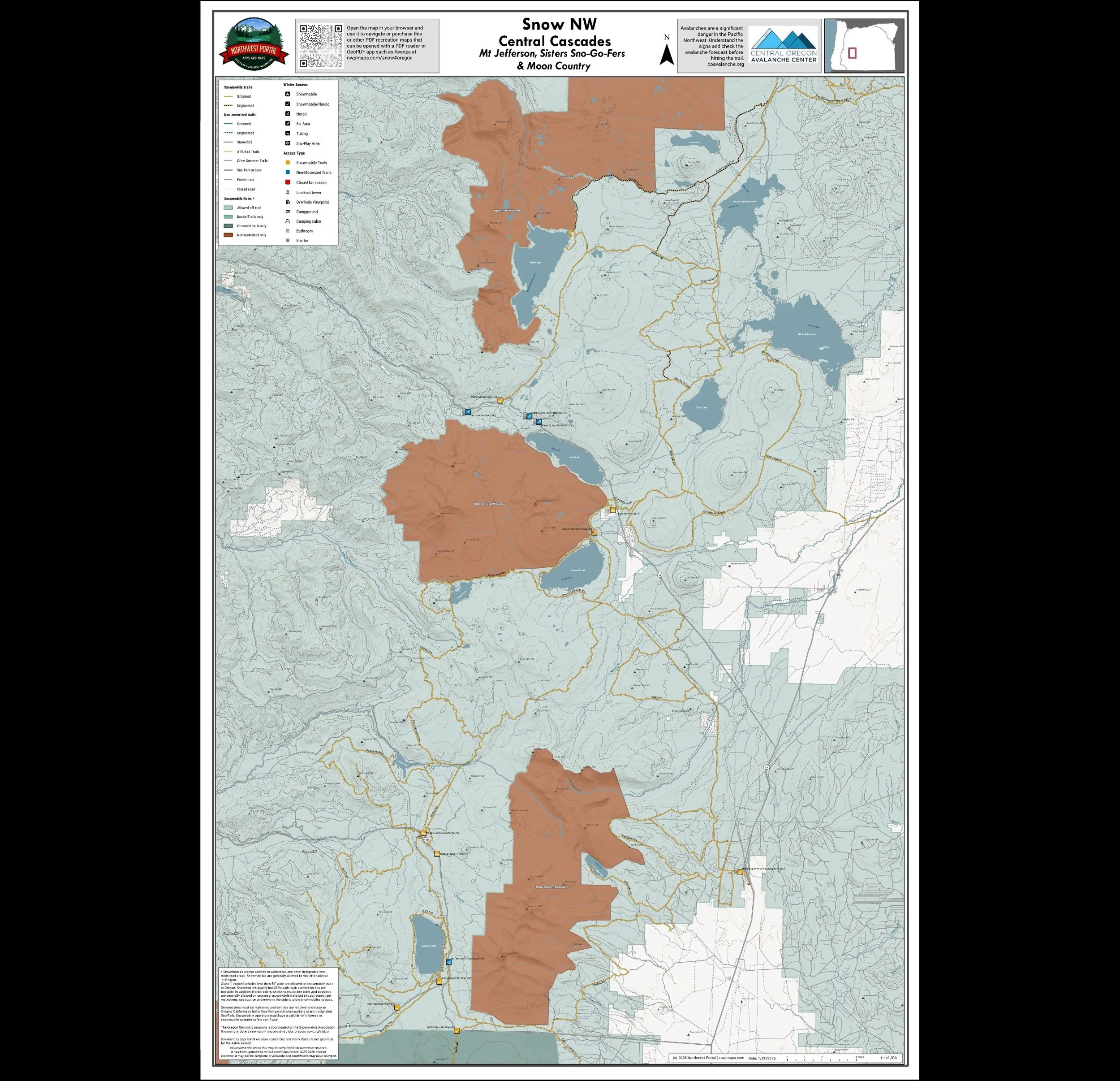
This map shows winter trails in Oregon’s Central Cascades that are groomed by the Mt Jefferson, Sisters-Go-Fers & Moon Country snowmobile clubs. It is part of a series of winter recreation map that show where you can ride your sled, ski or snowshoe in the Pacific Northwest. See which trails are groomed, what areas snowmobiles are allowed and where they are restricted. The maps, which were updated for the 2025-2026 season, include shelters, campgrounds, viewpoints, fire towers as well as summer trails and recreation roads, that are often utilized for winter recreation. This map shows trails served by Big Springs, Lava Lake, Little Nash, Ray Benson, Ikenick, Dutchman, Kapla, Edison Butte Wanoga, Upper Creek, Dutchman and Kapika Sno-Parks. The map includes areas in the Willamette and Deschutes National Forests in Lane and Deschutes Counties. It is a poster sized (24x36”) PDF at a 1:100,000 scale that you can print or use with a GeoPDF app such as Avenza.
South Oregon Cascades
Umpqua, Rogue River-Siskiyou & Fremon-Winema National Forest and Cascade Siskiyou National Monument
Rogue Snowmobilers, Chiloquin Ridge Riders, Klamath Basin Snowdrifters & Hi Desert Stormtroopers
Tabloid Size (11x17”)
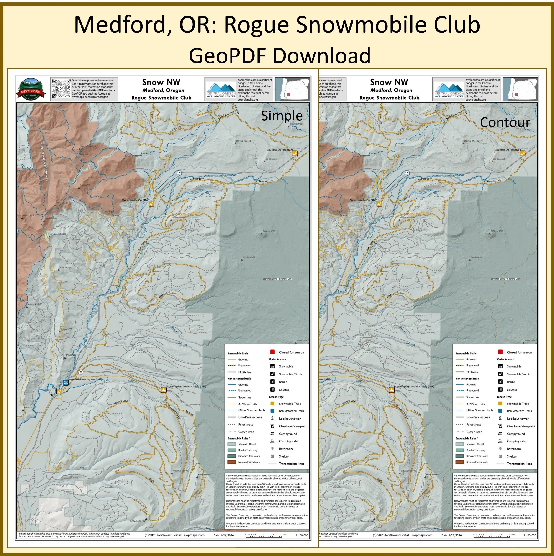
This map of winter trails in Oregon's Rogue River-Siskiyou National forest that are groomed by the Rogue Snowmobilers is part of a series of winter recreation map that show where you can ride your sled, ski or snowshoe in the Pacific Northwest. See which trails are groomed, what areas snowmobiles are allowed and where they are restricted. The maps, which were updated for the 2025-2026 season, include shelters, campgrounds, viewpoints, fire towers as well as summer trails and recreation roads, that are often utilized for winter recreation. It includes trails out of the Three Lakes, Claude Lewis, and Thousand Springs Sno-Parks in Jackson and Klamath counties. The map is a tabloid sized (11x17”) PDF at a 1:100,000 scale that you can print or use with a GeoPDF app such as Avenza. You will receive two versions of the map, one with contour lines and one without.
Poster (24x36”)
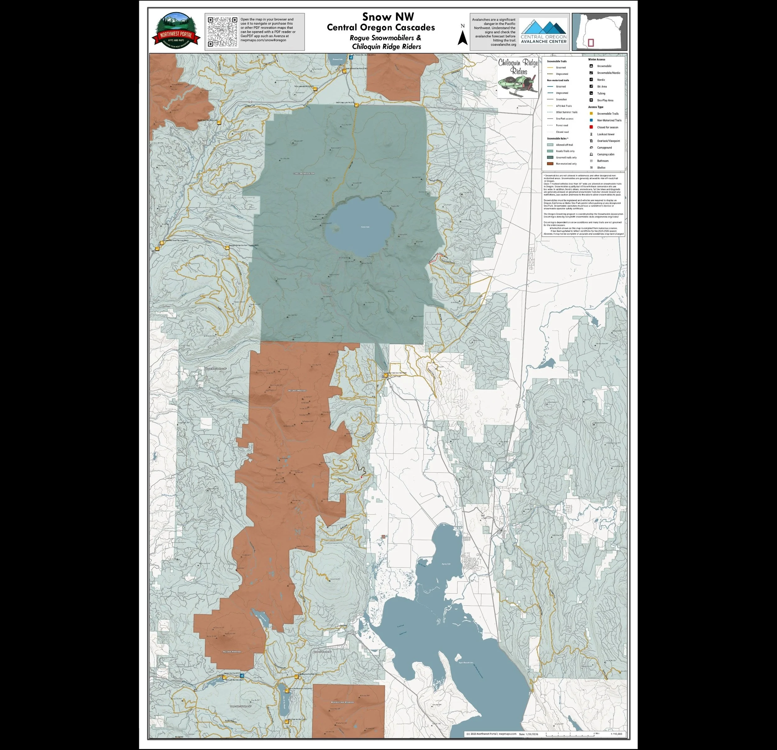
This map shows winter trails in Oregon’s Central Cascades that are groomed by the Rogue Snowmobilers & Chiloquin Ridge Riders snowmobile clubs. It is part of a series of winter recreation map that show where you can ride your sled, ski or snowshoe in the Pacific Northwest. See which trails are groomed, what areas snowmobiles are allowed and where they are restricted. The maps, which were updated for the 2025-2026 season, include shelters, campgrounds, viewpoints, fire towers as well as summer trails and recreation roads, that are often utilized for winter recreation. This map shows trails served by Three Lakes, Claude Lewis, Thousand Springs and Annie Creek Sno-Park Sno-Parks as well as trails east of Upper Klamath Lake. The map includes areas in the Rogue River-Siskiyou and Fremont-Winema National Forests in Jackson and Klamath Counties. It is a poster sized (24x36”) PDF at a 1:100,000 scale that you can print or use with a GeoPDF app such as Avenza.
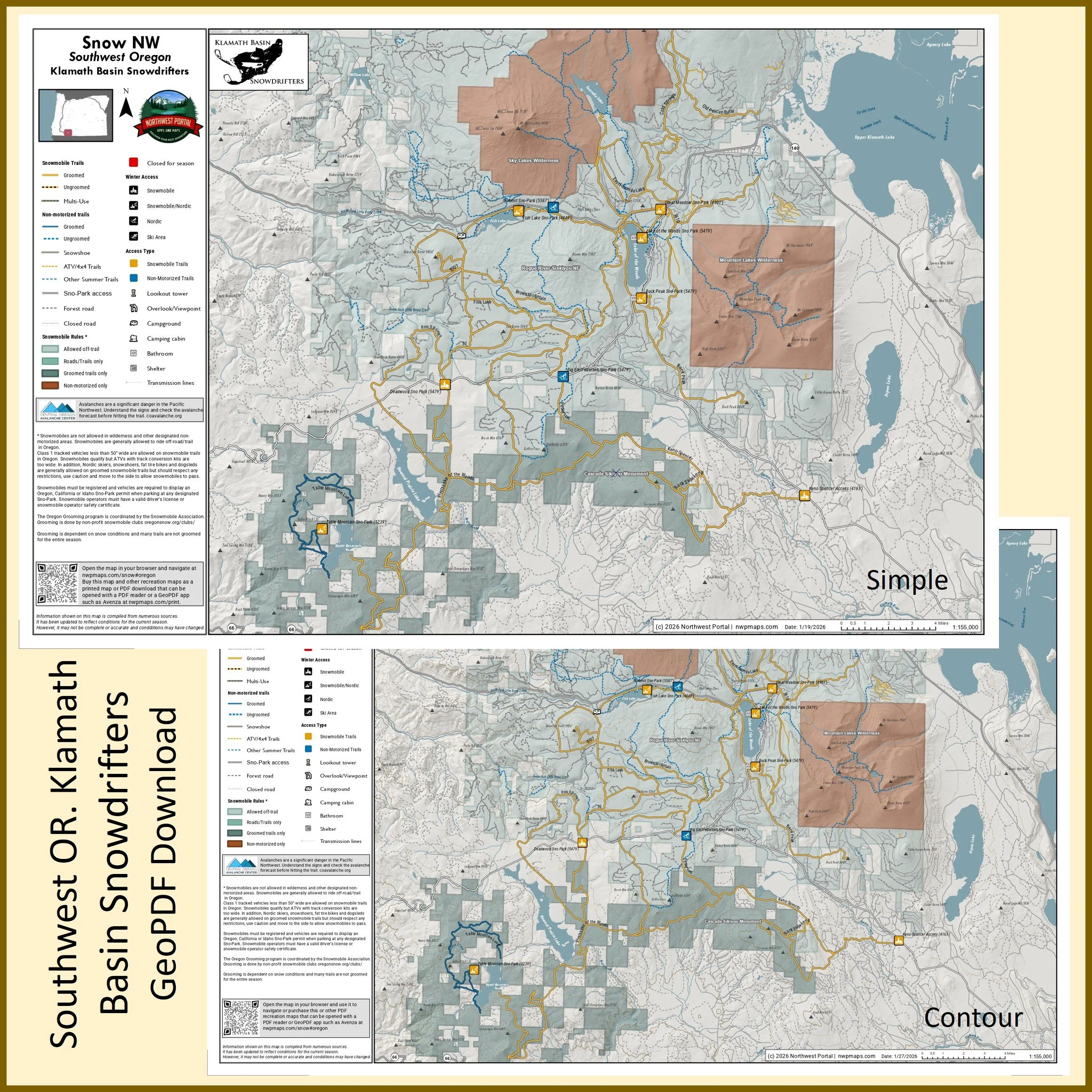
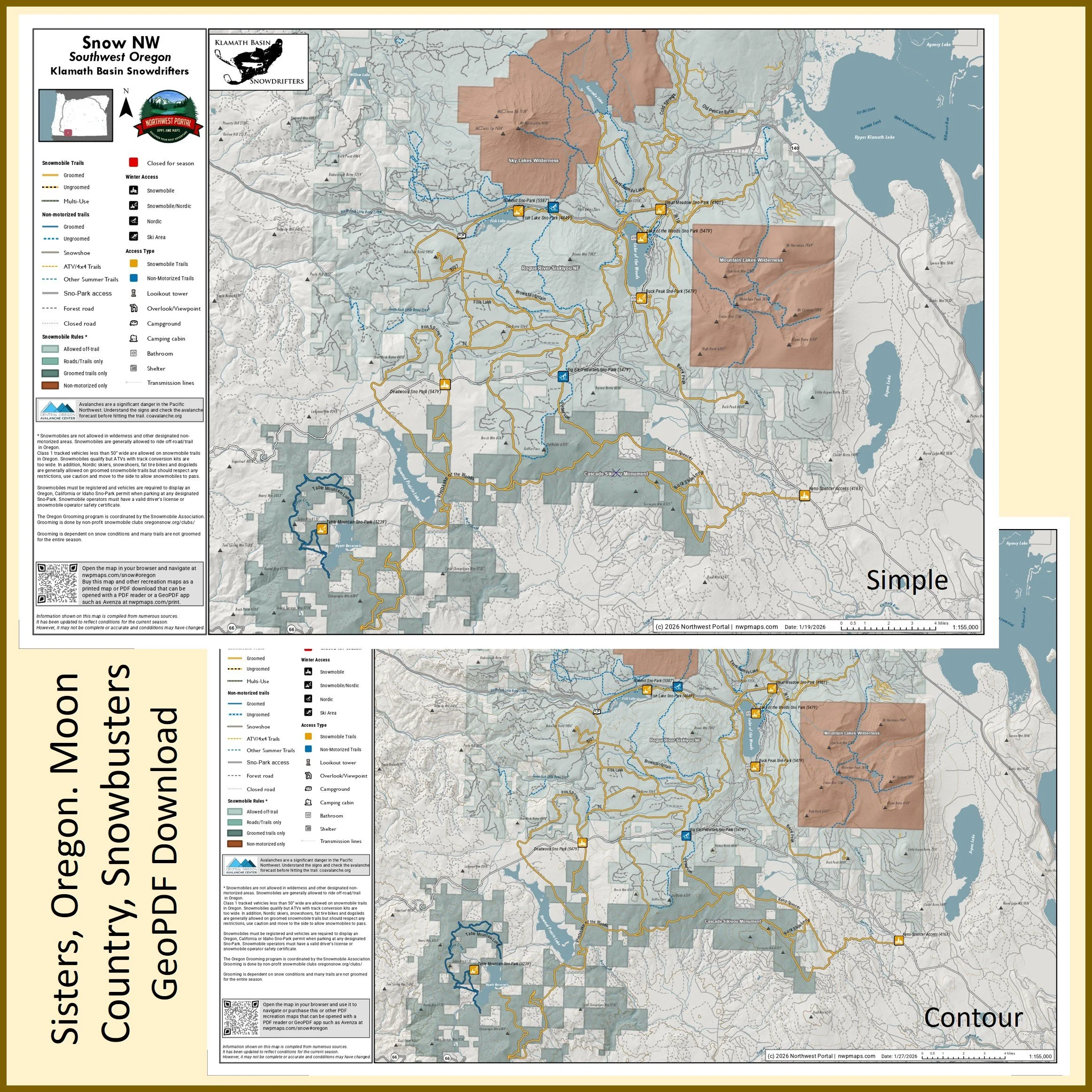
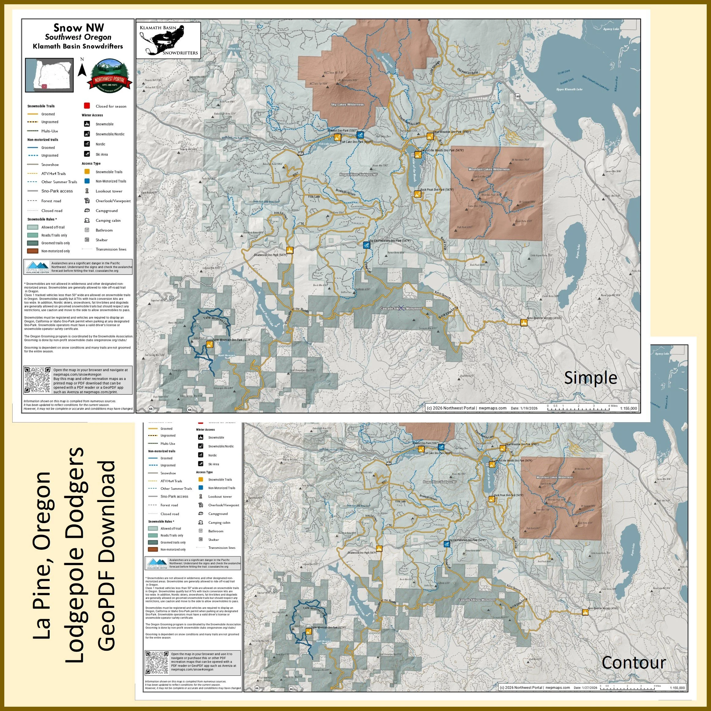
This map of winter trails in Oregon’s Cascade Siskiyou National Monument and the Rogue-River-Siskiyou and Fremont-Winema National Forests that are groomed by the Klamath Basin Snowdrifters is part of a series of winter recreation map that show where you can ride your sled, ski or snowshoe in the Pacific Northwest. See which trails are groomed, what areas snowmobiles are allowed and where they are restricted. The maps, which were updated for the 2025-2026 season, include shelters, campgrounds, viewpoints, fire towers as well as summer trails and recreation roads, that are often utilized for winter recreation. It includes trails out of the Table Mountain, Deadwood, Buck Peak, Lake of the Woods, Great Meadow, Fish Lake, and Keno Spencer Access Sno-Parks in Jackson and Klamath counties. The map is a tabloid sized (11x17”) PDF at a 1:155,000 scale that you can print or use with a GeoPDF app such as Avenza. You will receive two versions of the map, one with contour lines and one without.
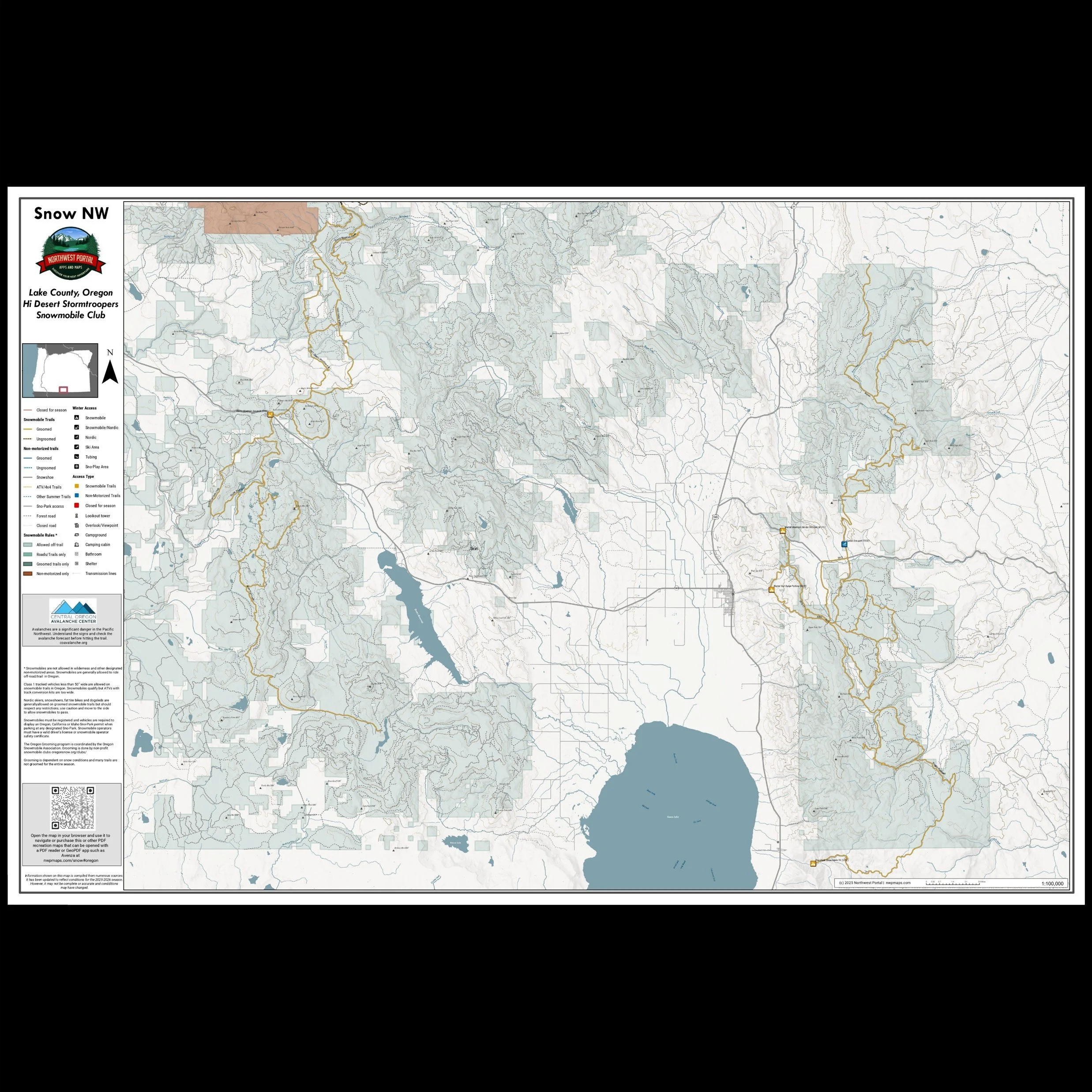
This map shows winter trails in Southwest Oregon that are groomed by the Hi Desert Storm Troppers Snowmobile Club. It is part of a series of winter recreation map that show where you can ride your sled, ski or snowshoe in the Pacific Northwest. See which trails are groomed, what areas snowmobiles are allowed and where they are restricted. The maps, which were updated for the 2025-2026 season, include shelters, campgrounds, viewpoints, fire towers as well as summer trails and recreation roads, that are often utilized for winter recreation. This map shows trails served by Pine Creek, Warner Mountain, Warner Gun Range and Quartz Mountain Sno-Parks. The map includes areas in the Fremont-Winema National Forest in Lake County. It is a poster sized (24x36”) PDF at a 1:100,000 scale that you can print or use with a GeoPDF app such as Avenza.
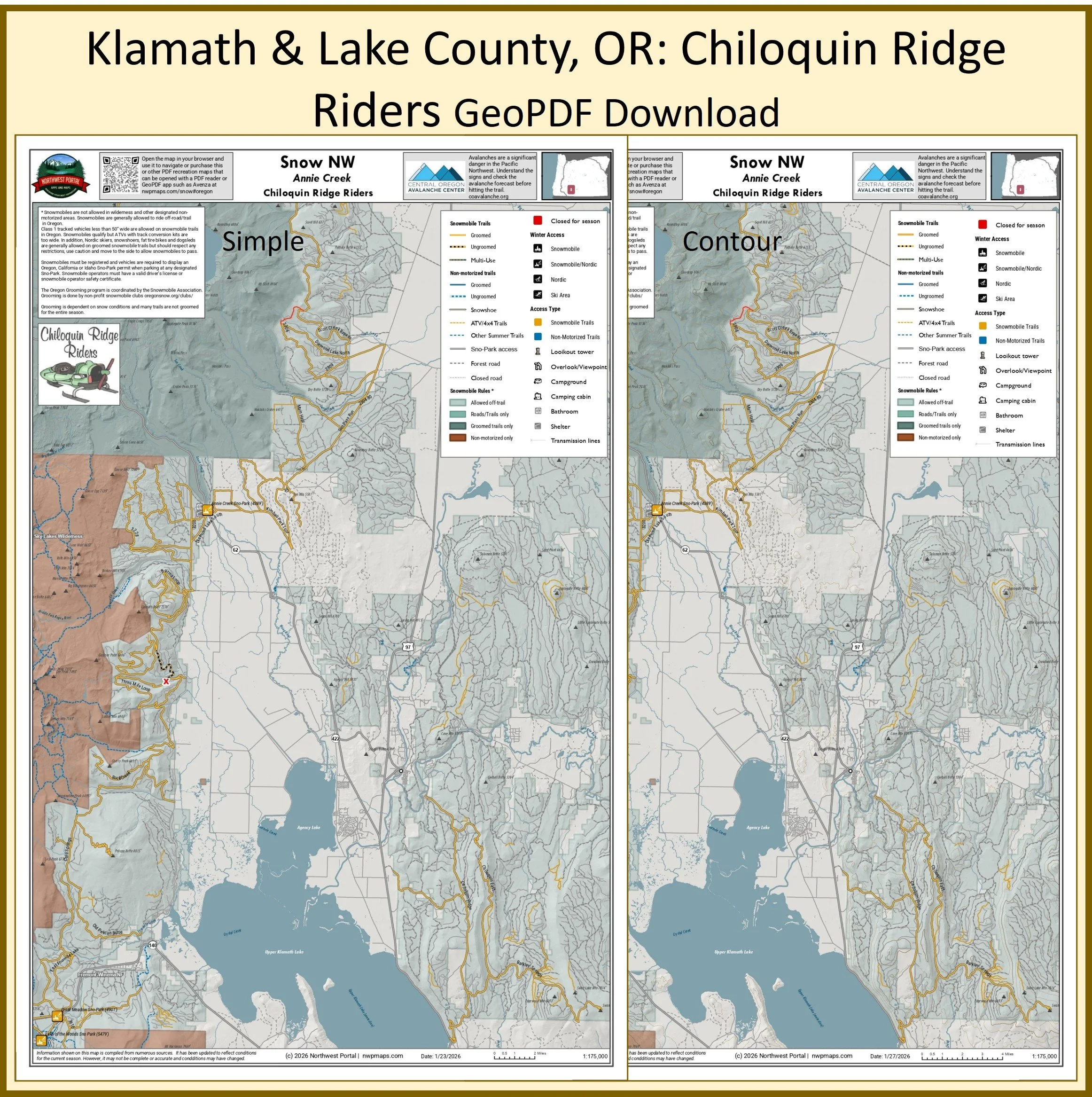
This map of winter trails in Oregon's Fremont-Winema National Forest that are groomed by the Chiloquin Ridge Riders is part of a series of winter recreation map that show where you can ride your sled, ski or snowshoe in the Pacific Northwest. See which trails are groomed, what areas snowmobiles are allowed and where they are restricted. The maps, which were updated for the 2025-2026 season, include shelters, campgrounds, viewpoints, fire towers as well as summer trails and recreation roads, that are often utilized for winter recreation. It includes trails out of the Annie Creek Sno-Park and those east of Upper Klamath Lake in Klamath County, Oregon. The map is a tabloid sized (11x17”) PDF at a 1:175,000 scale that you can print or use with a GeoPDF app such as Avenza. You will receive two versions of the map, one with contour lines and one without.
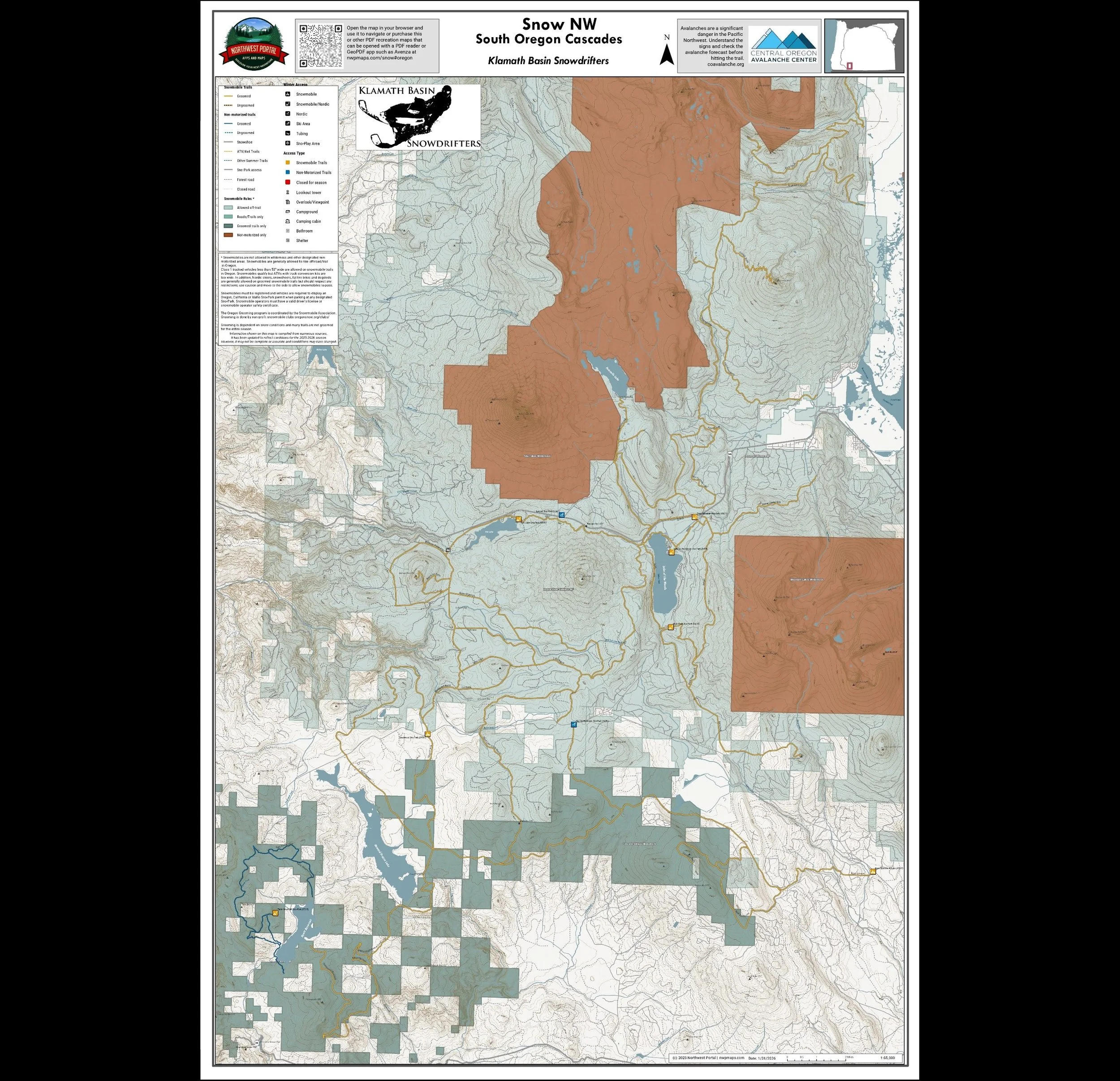
This map shows winter trails in Oregon’s Klamath Basin that are groomed by the Klamath Basin Snowdrifters. snowmobile clubs. It is part of a series of winter recreation map that show where you can ride your sled, ski or snowshoe in the Pacific Northwest. See which trails are groomed, what areas snowmobiles are allowed and where they are restricted. The maps, which were updated for the 2025-2026 season, include shelters, campgrounds, viewpoints, fire towers as well as summer trails and recreation roads, that are often utilized for winter recreation. This map shows trails served by Table Mountain, Deadwood, Buck Peak, Lake of the Woods, Great Meadow, Fish Lake, and Keno Spencer Sno-Parks. The map area includes areas in the Cascade Siskiyou National Monument and the Rogue-River-Siskiyou and Fremont-Winema National Forest in Jackson and Klamath counties. It is a poster sized (24x36”) PDF at a 1:65,000 scale that you can print or use with a GeoPDF app such as Avenza.
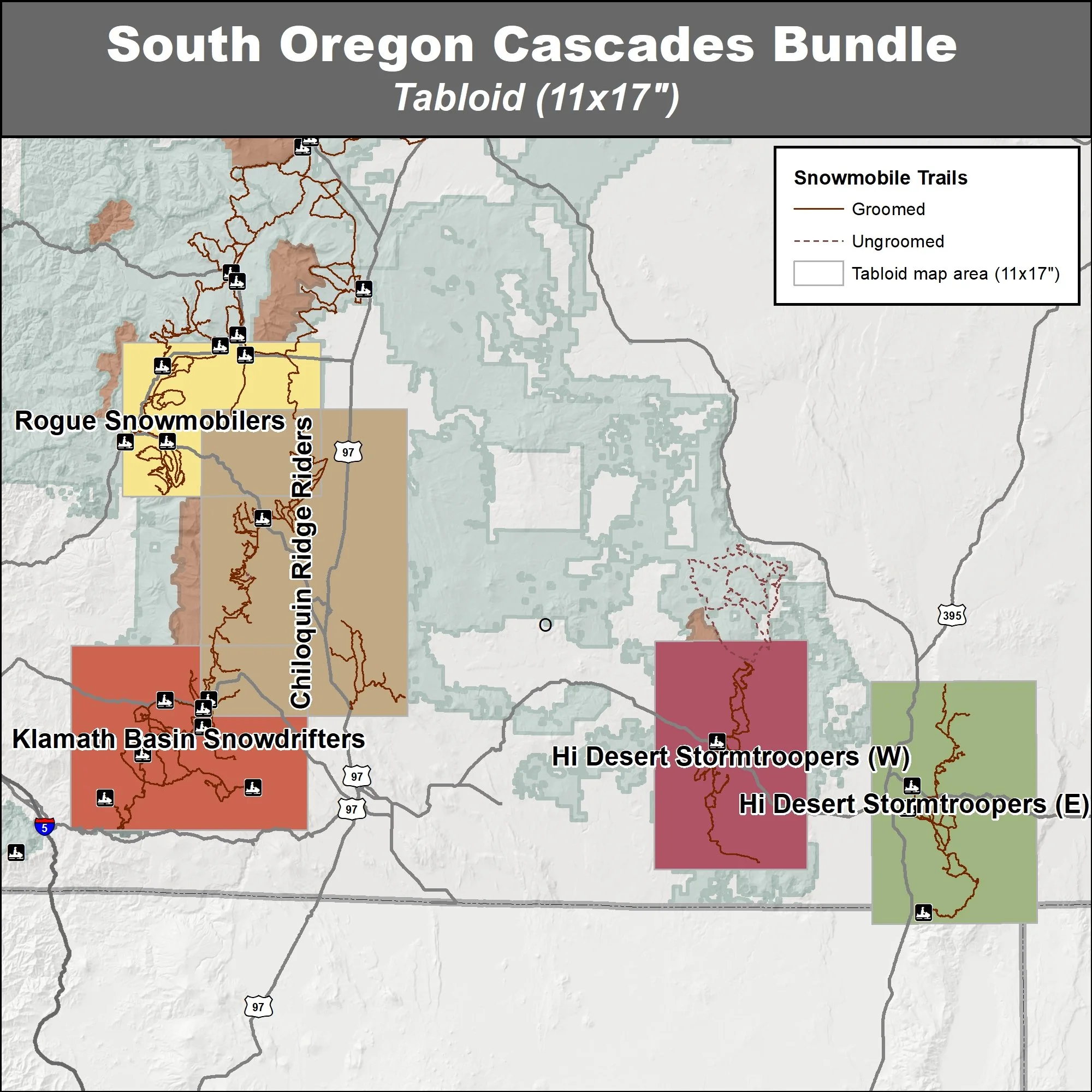
This bundle contains five maps of snowmobile trails in Oregon’s Central Cascades that are groomed by the Rogue Snowmobilers, Chiloquin Ridge Riders, Klamath Basin Snowdrifters and Hi Desert Stormtroopers. These maps are part of a series of winter recreation map that show where you can ride your sled, ski or snowshoe in the Pacific Northwest. See which trails are groomed, what areas snowmobiles are allowed and where they are restricted. The maps, which were updated for the 2025-2026 season, include shelters, campgrounds, viewpoints, fire towers as well as summer trails and recreation roads, that are often utilized for winter recreation. You will receive two versions of each area, one with contour lines and one without.
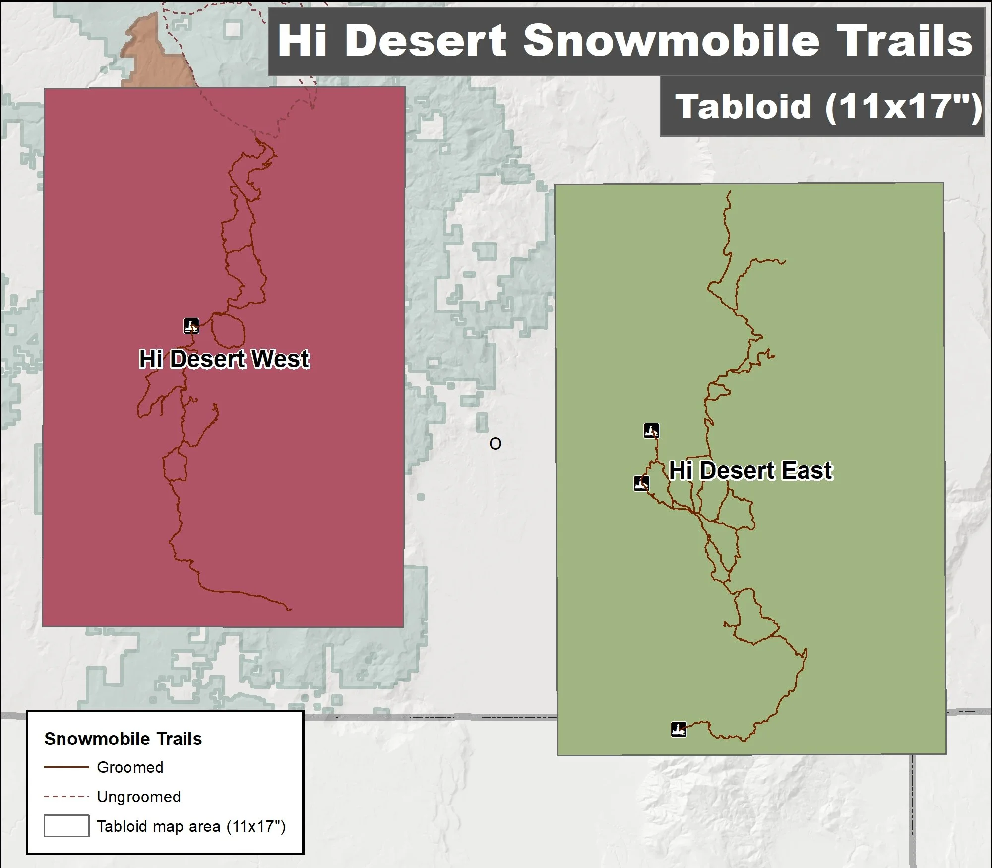
This set of maps of winter trails in Oregon's Fremont-Winema National Forest that are groomed by the Hi Desert Storm Troopers is part of a series of winter recreation map that show where you can ride your sled, ski or snowshoe in the Pacific Northwest. See which trails are groomed, what areas snowmobiles are allowed and where they are restricted. The maps, which were updated for the 2025-2026 season, include shelters, campgrounds, viewpoints, fire towers as well as summer trails and recreation roads, that are often utilized for winter recreation. This package includes two maps for Lake County: The western map, showing the trails out of the Quartz Mountain Sno-Park in Lake county, is 1:140,000, and the eastern map, showing trails out of the Pine Creek, Warner Mountain, and Warner Gun Range Sno-Parks is 140,000 scale. Both maps are tabloid sized (11x17”) PDF that you can print or use with a GeoPDF app such as Avenza. You will receive two versions of the map, one with contour lines and one without.
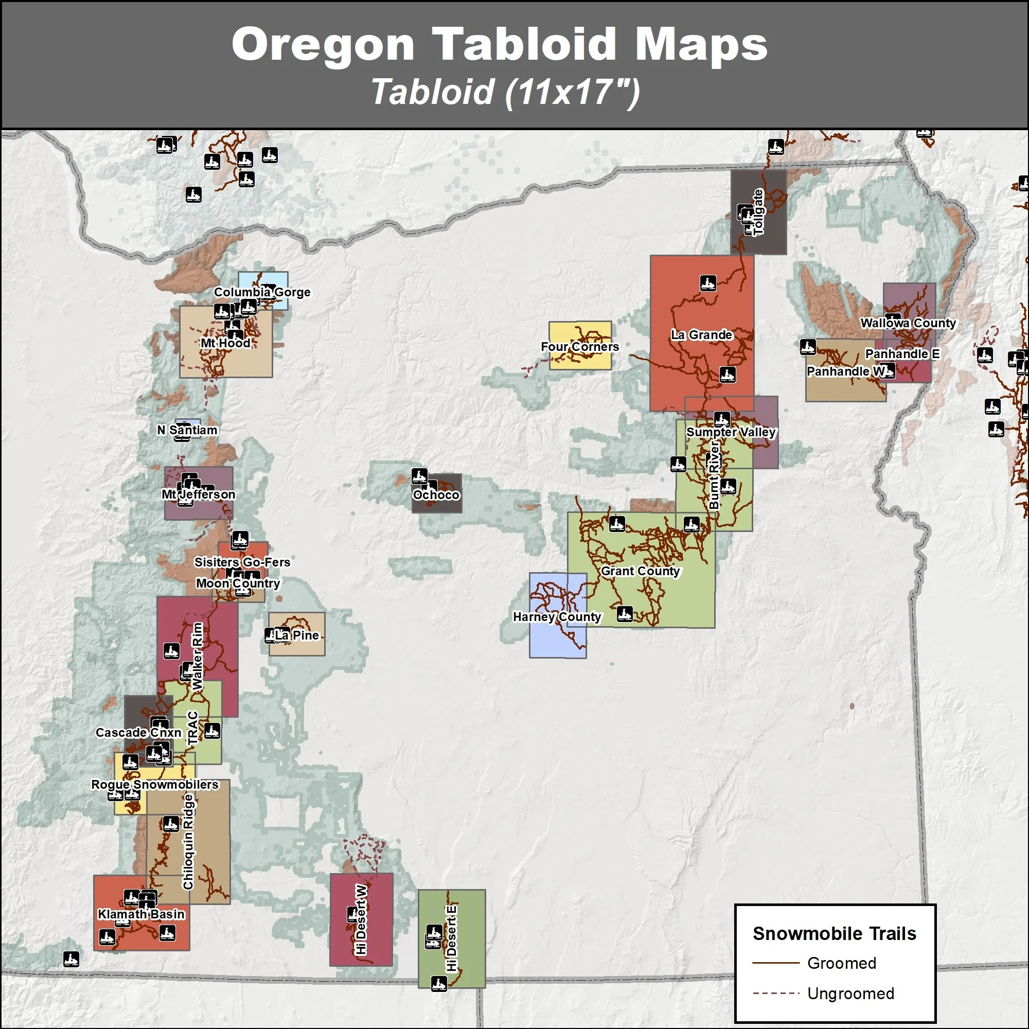
Eastern Oregon - Blue Mountains
Umatilla, Ochoco, Malheur & Wallowa-Whitman National Forest
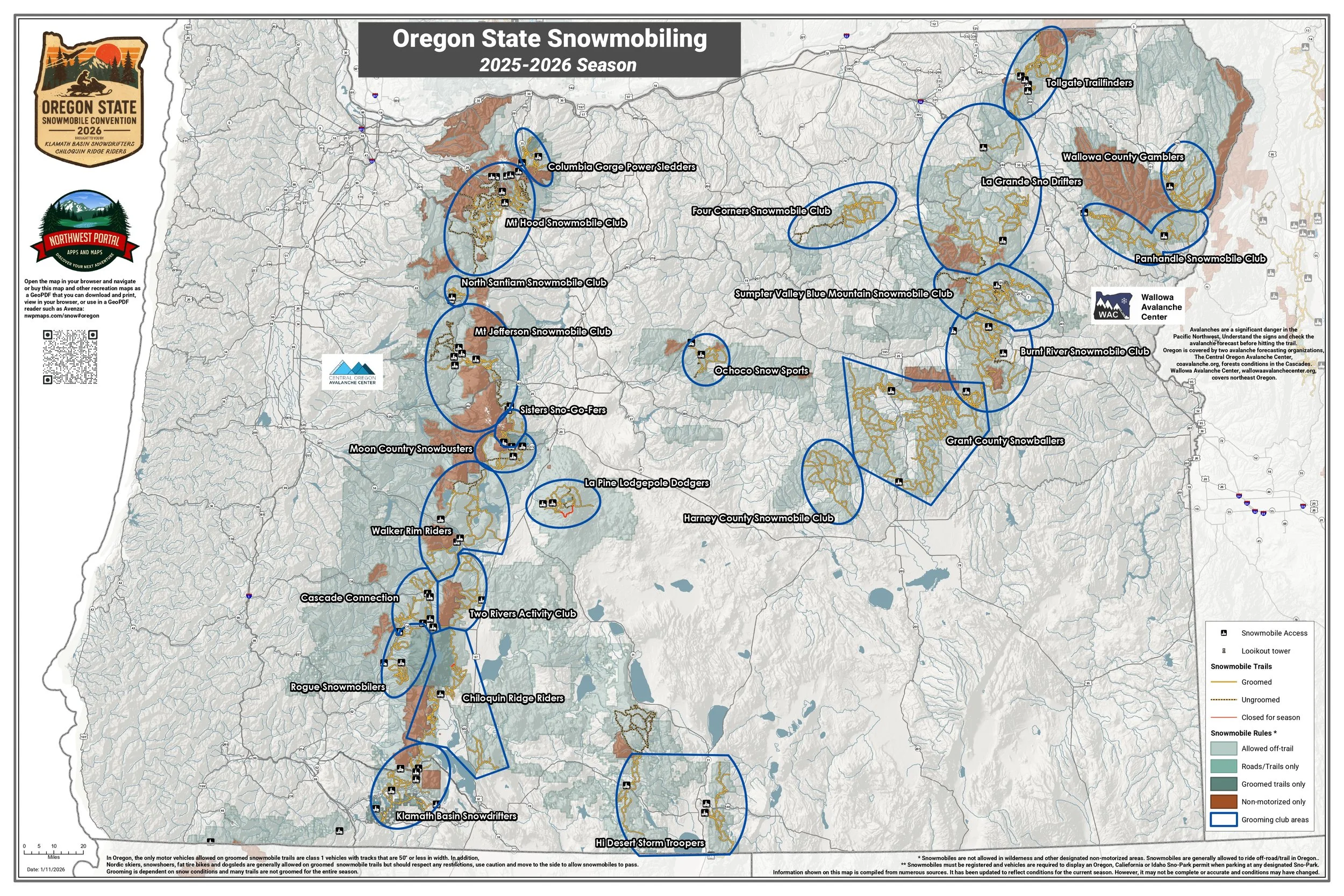
Burnt River Snowmobile Club, Four Corners Snowmobile Club, Grant County Snowballers Club, Harney County Snowmobile Club, La Pine Lodgepole Dodgers, LaGrande Sno-Drifters, Panhandle Snowmobile Club E, Panhandle Snowmobile Club W, Sumpter Valley Blue Mountain Snowmobile Club, Tollgate Trailfinders and Wallowa County Gamblers.
Tabloid Size (11x17”)
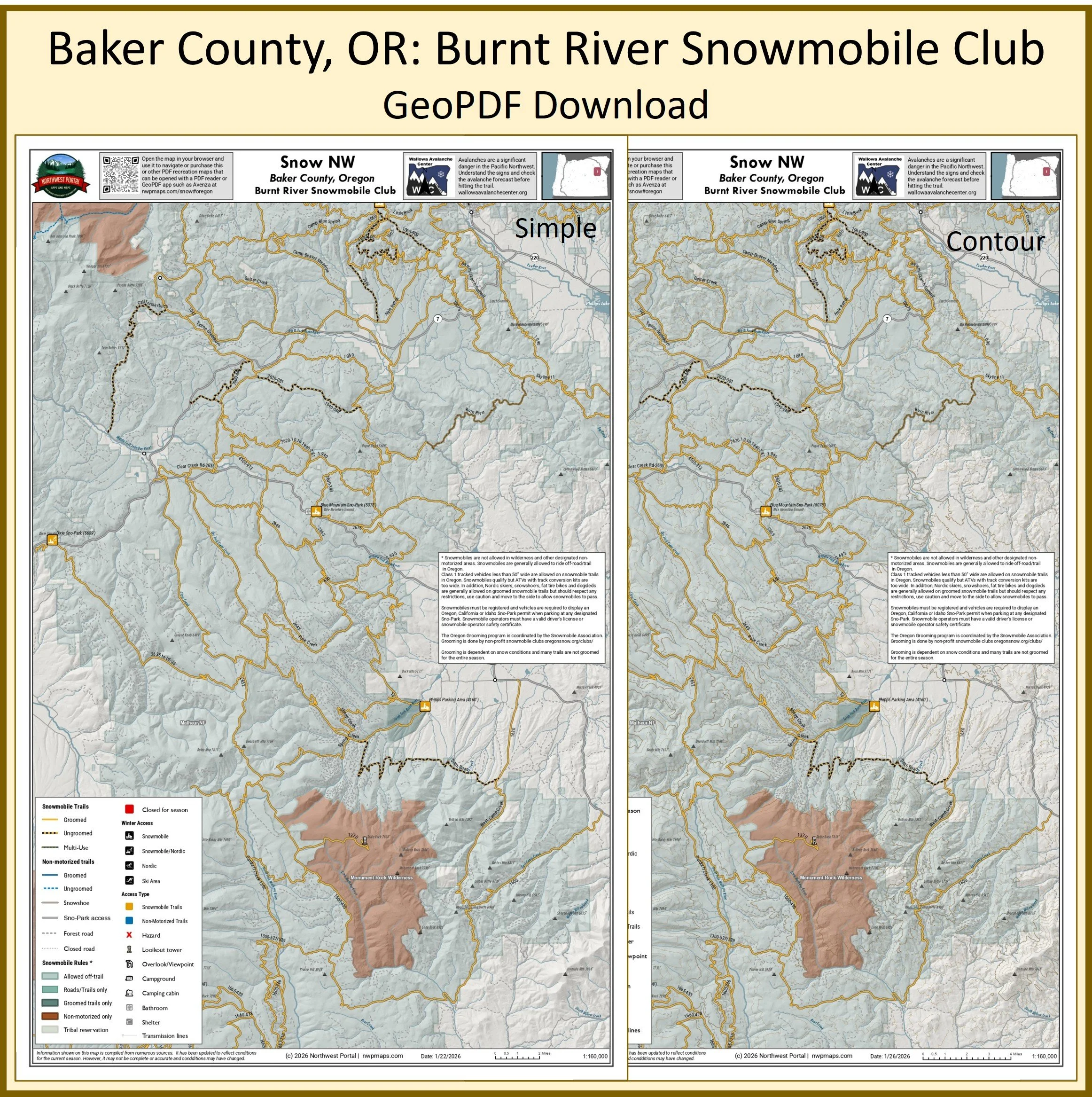
This map of winter trails in Oregon's Wallowa Whitman and Malheur National Forest that are groomed by the Burnt River Snowmobile Club is part of a series of winter recreation map that show where you can ride your sled, ski or snowshoe in the Pacific Northwest. See which trails are groomed, what areas snowmobiles are allowed and where they are restricted. The maps, which were updated for the 2025-2026 season, include shelters, campgrounds, viewpoints, fire towers as well as summer trails and recreation roads, that are often utilized for winter recreation. It includes trails out of the Dixie and Blue Mountain Sno-Parks and the Philps Parking Area in Grant and Baker County. The map is a tabloid sized (11x17”) PDF at a 1:160,000 scale that you can print or use with a GeoPDF app such as Avenza. You will receive two versions of the map, one with contour lines and one without.
This map of winter trails in Oregon's Deschutes National Forest that are groomed by the La Pine Lodgepole Dodgers is part of a series of winter recreation map that show where you can ride your sled, ski or snowshoe in the Pacific Northwest. See which trails are groomed, what areas snowmobiles are allowed and where they are restricted. The maps, which were updated for the 2025-2026 season, include shelters, campgrounds, viewpoints, fire towers as well as summer trails and recreation roads, that are often utilized for winter recreation. It includes trails out of 6 and 10 Mile Sno-Parks in the Newberry/Paulina Lake area of Deschutes County.The map is a tabloid sized (11x17”) PDF at a 1:90,000 scale that you can print or use with a GeoPDF app such as Avenza. You will receive two versions of the map, one with contour lines and one without.
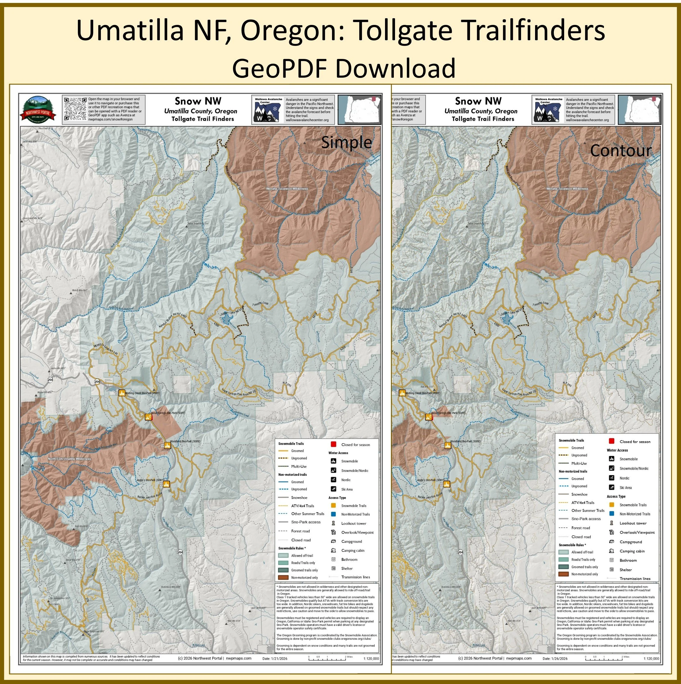
This map of winter trails in Oregon's Umatilla National Forest that are groomed by the Tollgate Trailfinders is part of a series of winter recreation map that show where you can ride your sled, ski or snowshoe in the Pacific Northwest. See which trails are groomed, what areas snowmobiles are allowed and where they are restricted. The maps, which were updated for the 2025-2026 season, include shelters, campgrounds, viewpoints, fire towers as well as summer trails and recreation roads, that are often utilized for winter recreation. It includes trails out of the Morning Creek, Spout Springs, Woodland, and Andie's Sno-Parks in Wallowa, Union, and Umatilla counties. The map is a tabloid sized (11x17”) PDF at a 1:120,000 scale that you can print or use with a GeoPDF app such as Avenza. You will receive two versions of the map, one with contour lines and one without.
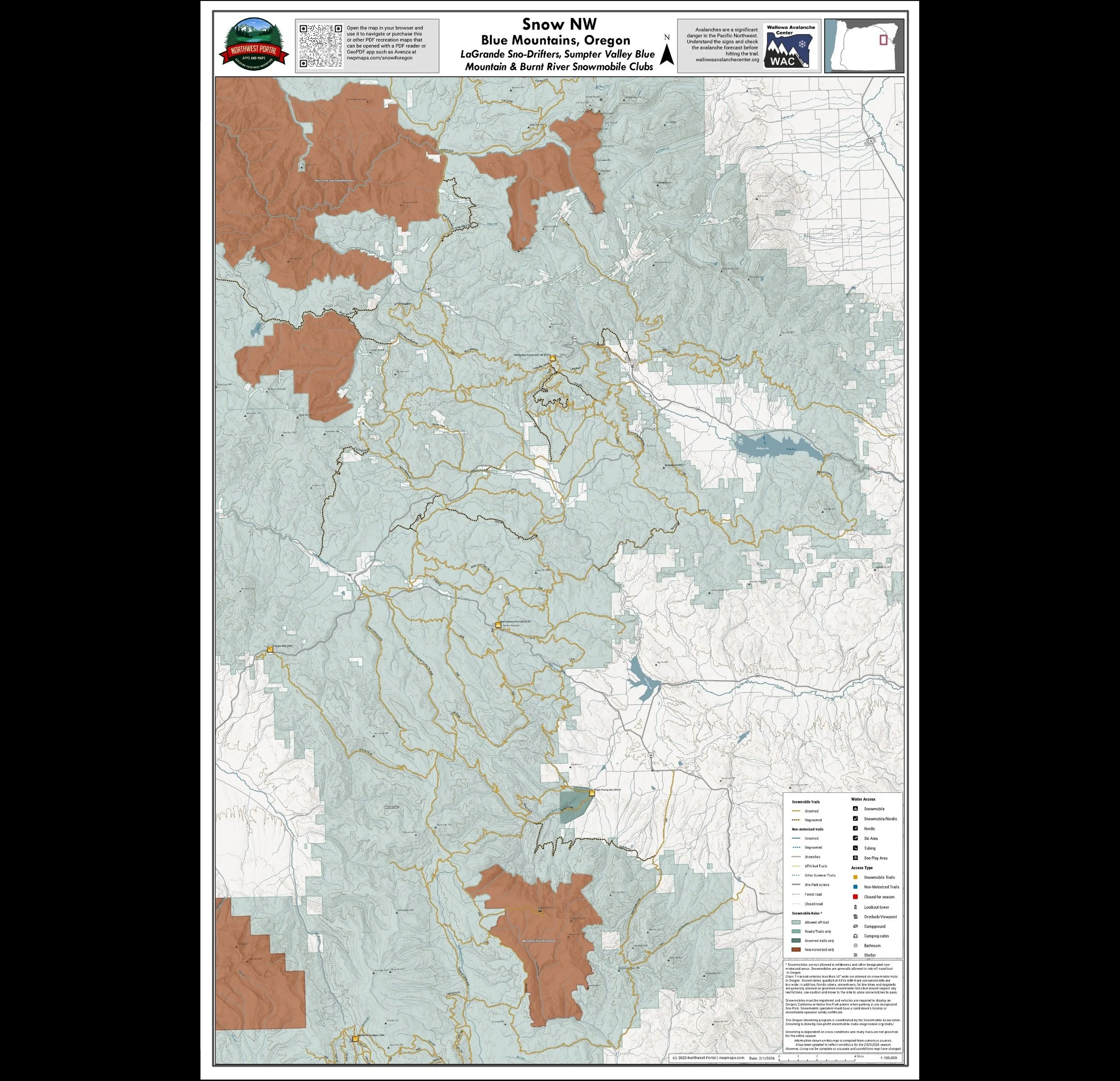
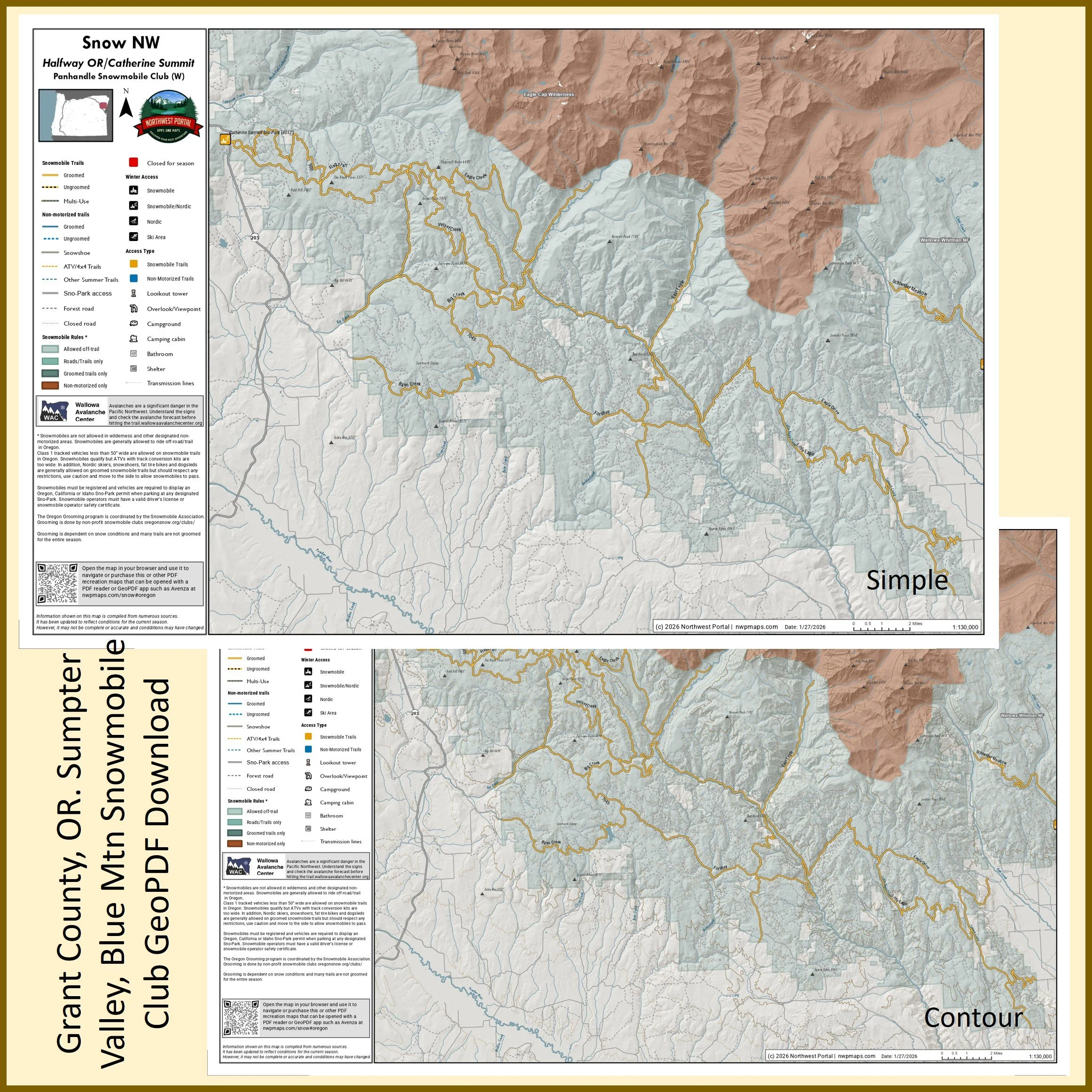
This map shows winter trails in Oregon’s Blue Mountains that are groomed by the LaGrande Sno-Drifters, Sumpter Valley Blue Mountain Snowmobile Club & Burnt River Snowmobile Clubs. It is part of a series of winter recreation map that show where you can ride your sled, ski or snowshoe in the Pacific Northwest. See which trails are groomed, what areas snowmobiles are allowed and where they are restricted. The maps, which were updated for the 2025-2026 season, include shelters, campgrounds, viewpoints, fire towers as well as summer trails and recreation roads, that are often utilized for winter recreation. This map shows trails served by the Blue Mountain, Blue Springs Summit, Grande Ronde, Meacham Divide/Mt.Emily Dixie and Philips Sno-Parks. The map includes areas in the Wallowa Whitman, Malheur and Umatilla National Forests in Baker, Grant and Union Counties. It is a poster sized (24x36”) PDF at a 1:100,000 scale that you can print or use with a GeoPDF app such as Avenza.
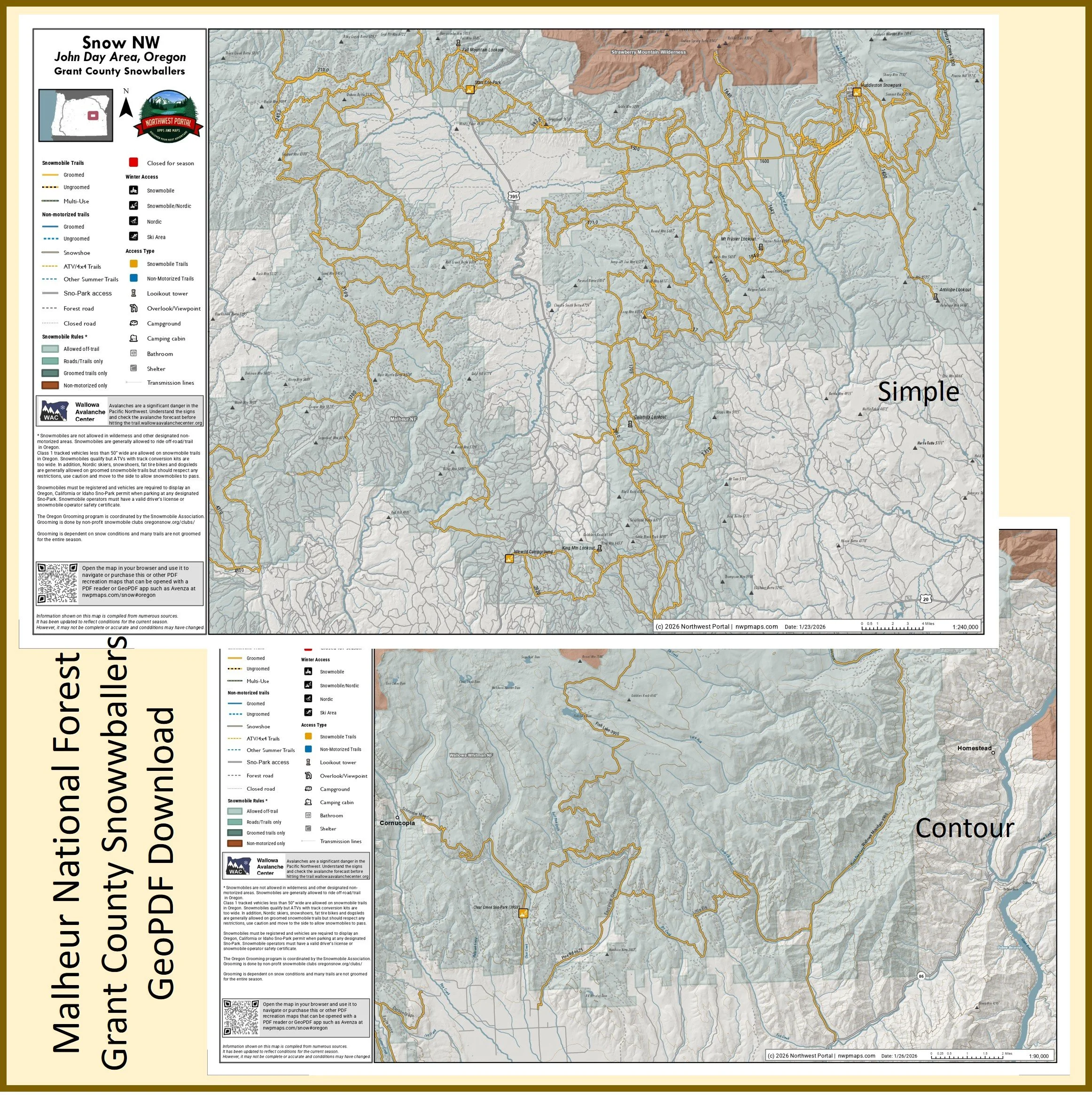
This map of winter trails in Oregon's Malheur National Forest that are groomed by the Grant County Snowballers is part of a series of winter recreation map that show where you can ride your sled, ski or snowshoe in the Pacific Northwest. See which trails are groomed, what areas snowmobiles are allowed and where they are restricted. The maps, which were updated for the 2025-2026 season, include shelters, campgrounds, viewpoints, fire towers as well as summer trails and recreation roads, that are often utilized for winter recreation. It includes trails out of the Starr, Huddleston, and Idlewild in Grant and Harney Counties . The map is a tabloid sized (11x17”) PDF at a 1:240,000 scale that you can print or use with a GeoPDF app such as Avenza. You will receive two versions of the map, one with contour lines and one without.
This map of winter trails in Oregon's Malheur and Wallowa-Whitman National Forests that are groomed by the Blue Mountain Snowmobile Club is part of a series of winter recreation map that show where you can ride your sled, ski or snowshoe in the Pacific Northwest. See which trails are groomed, what areas snowmobiles are allowed and where they are restricted. The maps, which were updated for the 2025-2026 season, include shelters, campgrounds, viewpoints, fire towers as well as summer trails and recreation roads, that are often utilized for winter recreation. It includes trails out of the Blue Mountain and blue Springs Summit Sno-Parks in Baker and Grant Counties. The map is a tabloid sized (11x17”) PDF at a 1:150,000 scale that you can print or use with a GeoPDF app such as Avenza. You will receive two versions of the map, one with contour lines and one without.
Poster (24x36”)
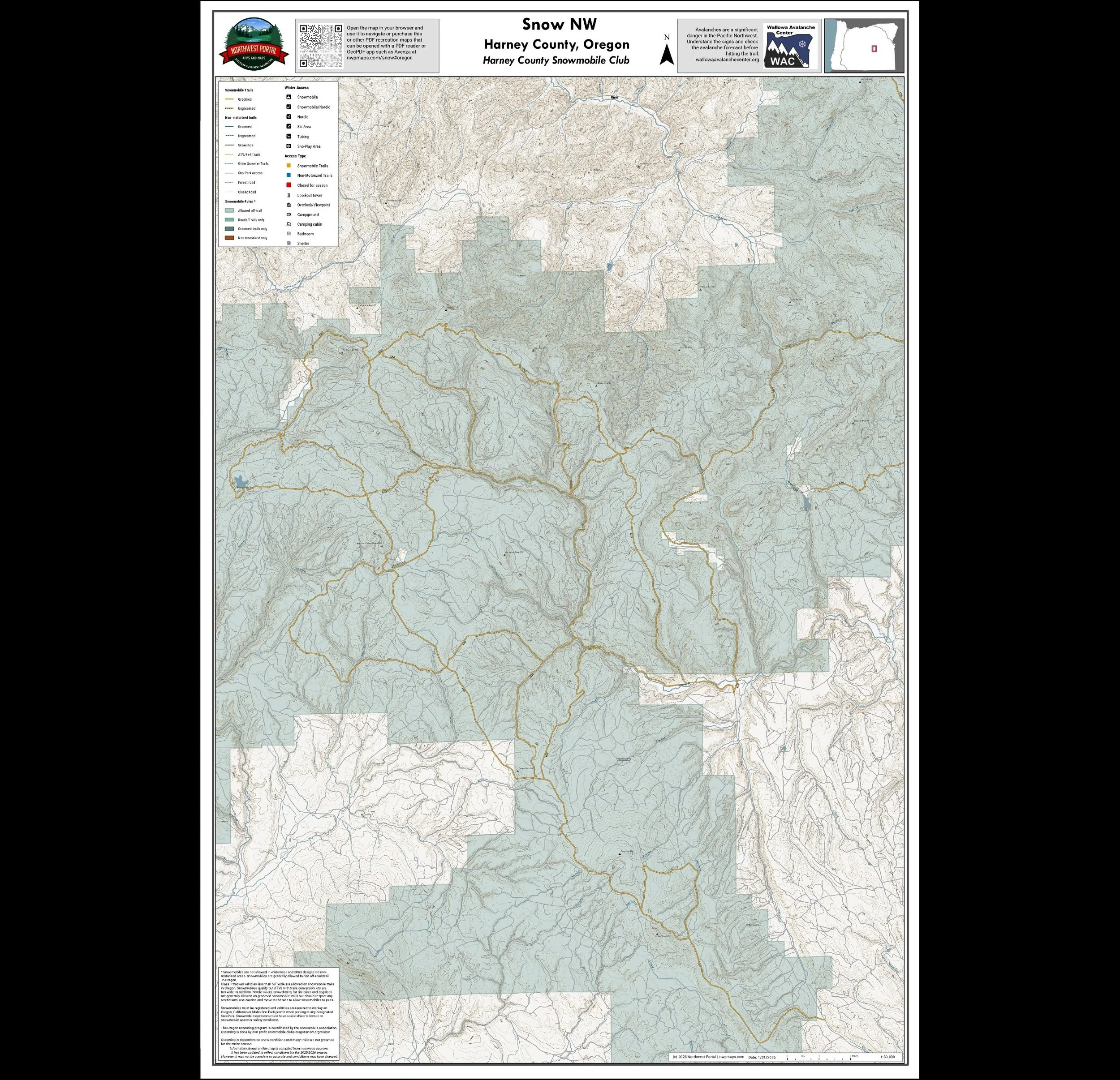
This map shows winter trails in Oregon’s Blue Mountainsthat are groomed by the Harney County Snowmobile Club. It is part of a series of winter recreation map that show where you can ride your sled, ski or snowshoe in the Pacific Northwest. See which trails are groomed, what areas snowmobiles are allowed and where they are restricted. The maps, which were updated for the 2025-2026 season, include shelters, campgrounds, viewpoints, fire towers as well as summer trails and recreation roads, that are often utilized for winter recreation. The map includes areas in the Malheur National Forest in Harney County. It is a poster sized (24x36”) PDF at a 1:60,000 scale that you can print or use with a GeoPDF app such as Avenza.
This map of winter trails in Oregon's Umatilla National Forest that are groomed by the Four Corners Snowmobile Club is part of a series of winter recreation map that show where you can ride your sled, ski or snowshoe in the Pacific Northwest. See which trails are groomed, what areas snowmobiles are allowed and where they are restricted. The maps, which were updated for the 2025-2026 season, include shelters, campgrounds, viewpoints, fire towers as well as summer trails and recreation roads, that are often utilized for winter recreation. It includes trails in Morrow and Umatilla County. The map is a tabloid sized (11x17”) PDF at a 1:240,000 scale that you can print or use with a GeoPDF app such as Avenza. You will receive two versions of the map, one with contour lines and one without.
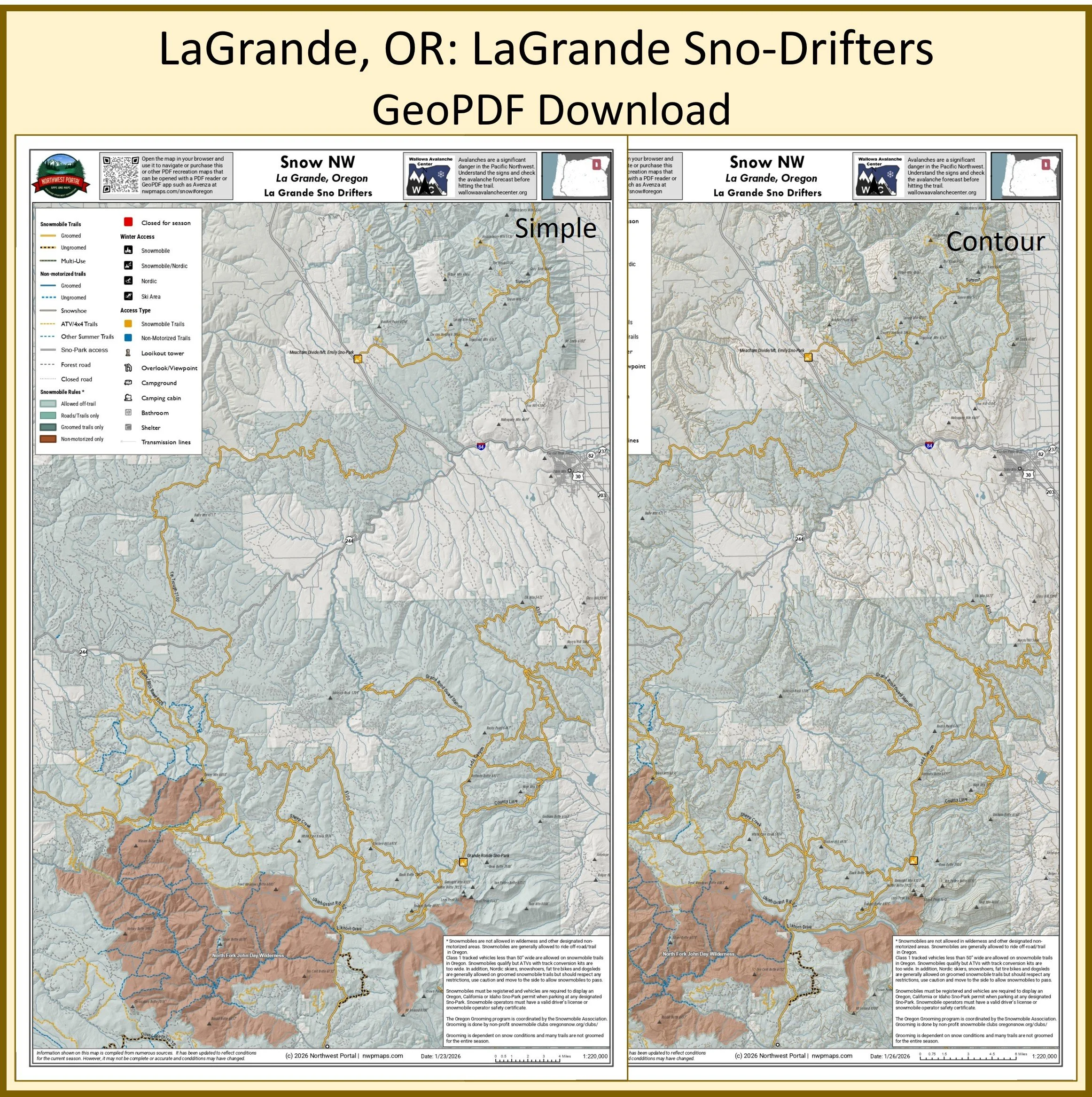
This map of winter trails in Oregon's Umatilla and Wallowa-Whitman National Forests that are groomed by the LaGrande Sno-Drifters is part of a series of winter recreation map that show where you can ride your sled, ski or snowshoe in the Pacific Northwest. See which trails are groomed, what areas snowmobiles are allowed and where they are restricted. The maps, which were updated for the 2025-2026 season, include shelters, campgrounds, viewpoints, fire towers as well as summer trails and recreation roads, that are often utilized for winter recreation. It includes trails out of the Grande Ronde and Meacham Divide/Mt.Emily Sno-Parks in Umatilla, Grant, and Union counties. The map is a tabloid sized (11x17”) PDF at a 1:220,000 scale that you can print or use with a GeoPDF app such as Avenza. You will receive two versions of the map, one with contour lines and one without.
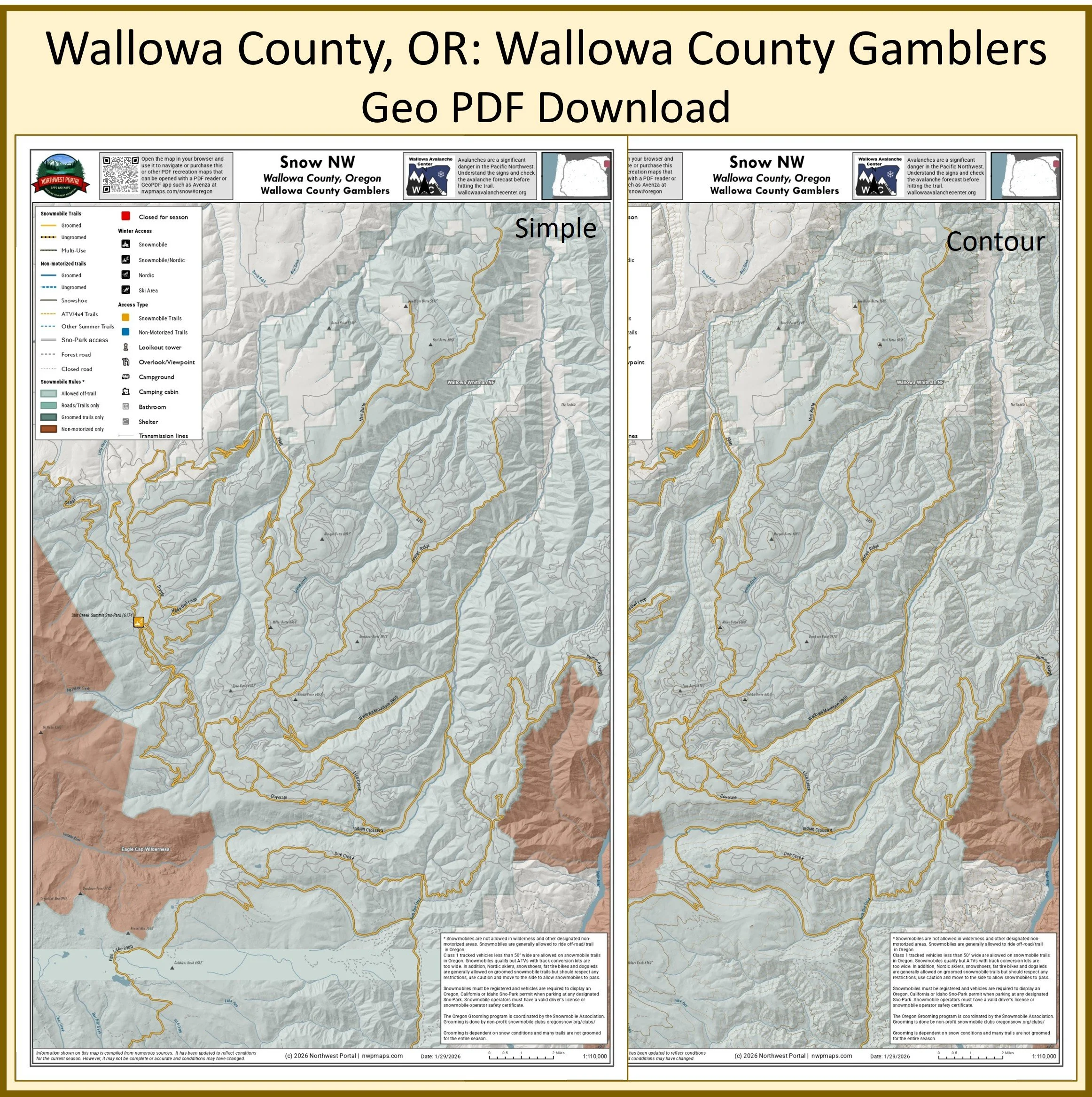
This map of winter trails in Oregon's Wallowa-Whitman National Forest that are groomed by the Wallowa County Gamblers is part of a series of winter recreation map that show where you can ride your sled, ski or snowshoe in the Pacific Northwest. See which trails are groomed, what areas snowmobiles are allowed and where they are restricted. The maps, which were updated for the 2025-2026 season, include shelters, campgrounds, viewpoints, fire towers as well as summer trails and recreation roads, that are often utilized for winter recreation. It includes trails out of the Salt Creek Summit Sno-Park in Wallowa County. The map is a tabloid sized (11x17”) PDF at a 1:110,000 scale that you can print or use with a GeoPDF app such as Avenza. You will receive two versions of the map, one with contour lines and one without.
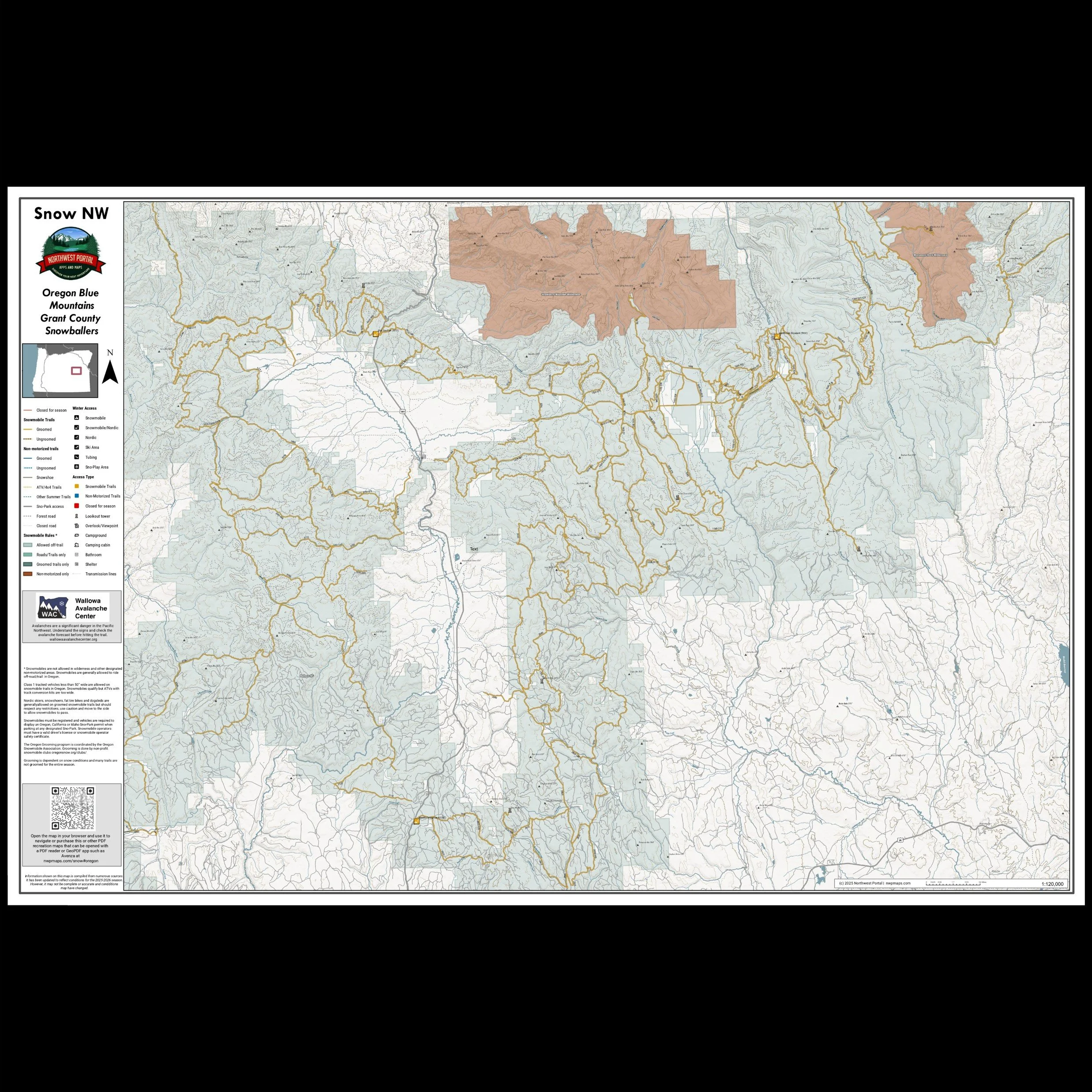
This map shows winter trails in Oregon’s Blue Mountains that are groomed by the Grant County Snowballers snowmobile club. It is part of a series of winter recreation map that show where you can ride your sled, ski or snowshoe in the Pacific Northwest. See which trails are groomed, what areas snowmobiles are allowed and where they are restricted. The maps, which were updated for the 2025-2026 season, include shelters, campgrounds, viewpoints, fire towers as well as summer trails and recreation roads, that are often utilized for winter recreation. This map shows trails served by Starr, Huddleston and Idlewild Sno-Parks. The map includes areas in the Malheur National Forest in Grant and Harney Counties. It is a poster sized (24x36”) PDF at a scale of 1:115,000 that you can print or use with a GeoPDF app such as Avenza.
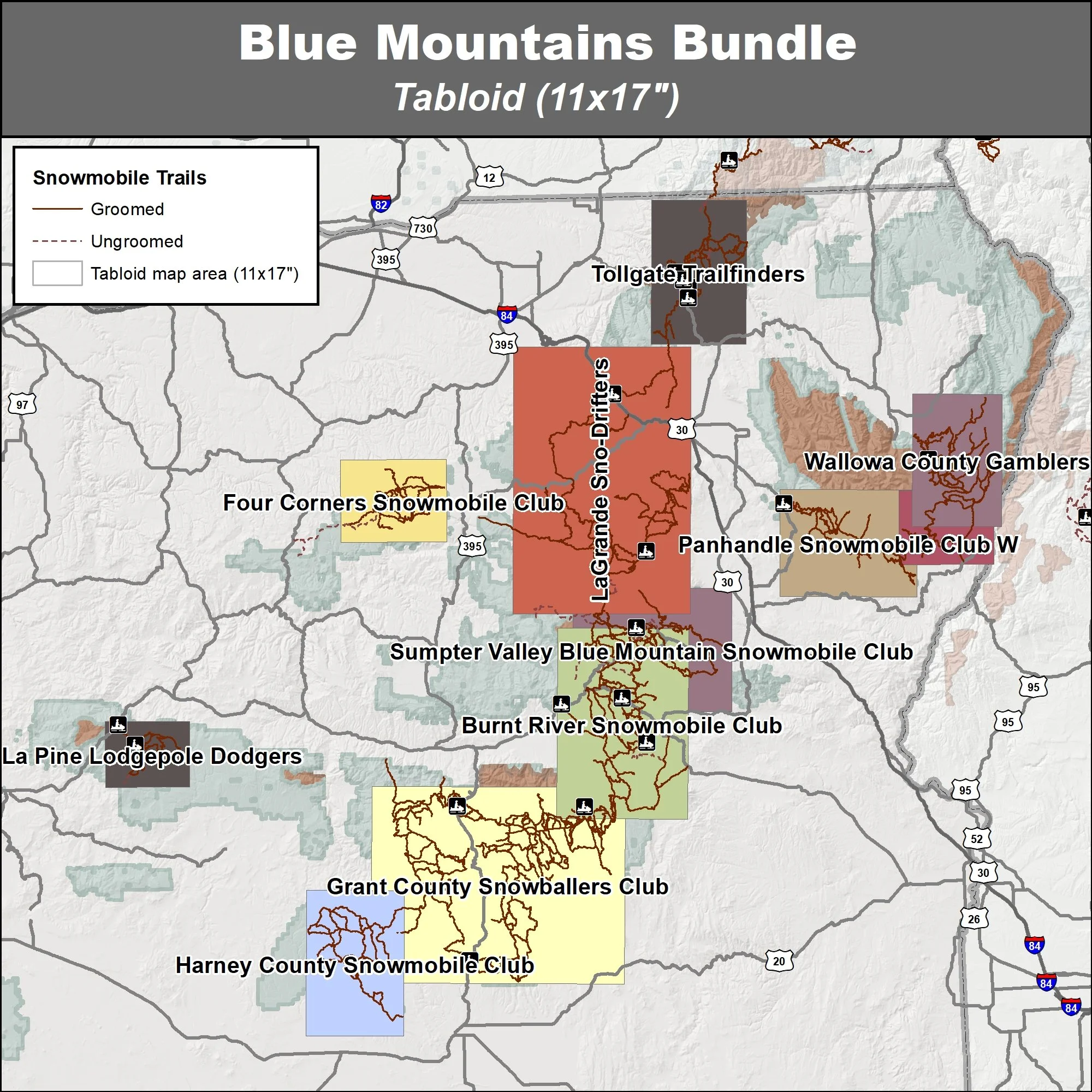
This bundle contains eleven maps of snowmobile trails in Oregon’s Blue Mountains. These trails are groomed by the Burnt River Snowmobile Club, Four Corners Snowmobile Club, Grant County Snowballers Club, Harney County Snowmobile Club, La Pine Lodgepole Dodgers, LaGrande Sno-Drifters, Panhandle Snowmobile Club E, Panhandle Snowmobile Club W, Sumpter Valley Blue Mountain Snowmobile Club, Tollgate Trailfinder and Wallowa County Gamblers. These maps are part of a series of winter recreation map that show where you can ride your sled, ski or snowshoe in the Pacific Northwest. See which trails are groomed, what areas snowmobiles are allowed and where they are restricted. The maps, which were updated for the 2025-2026 season, include shelters, campgrounds, viewpoints, fire towers as well as summer trails and recreation roads, that are often utilized for winter recreation. You will receive two versions of each area, one with contour lines and one without.
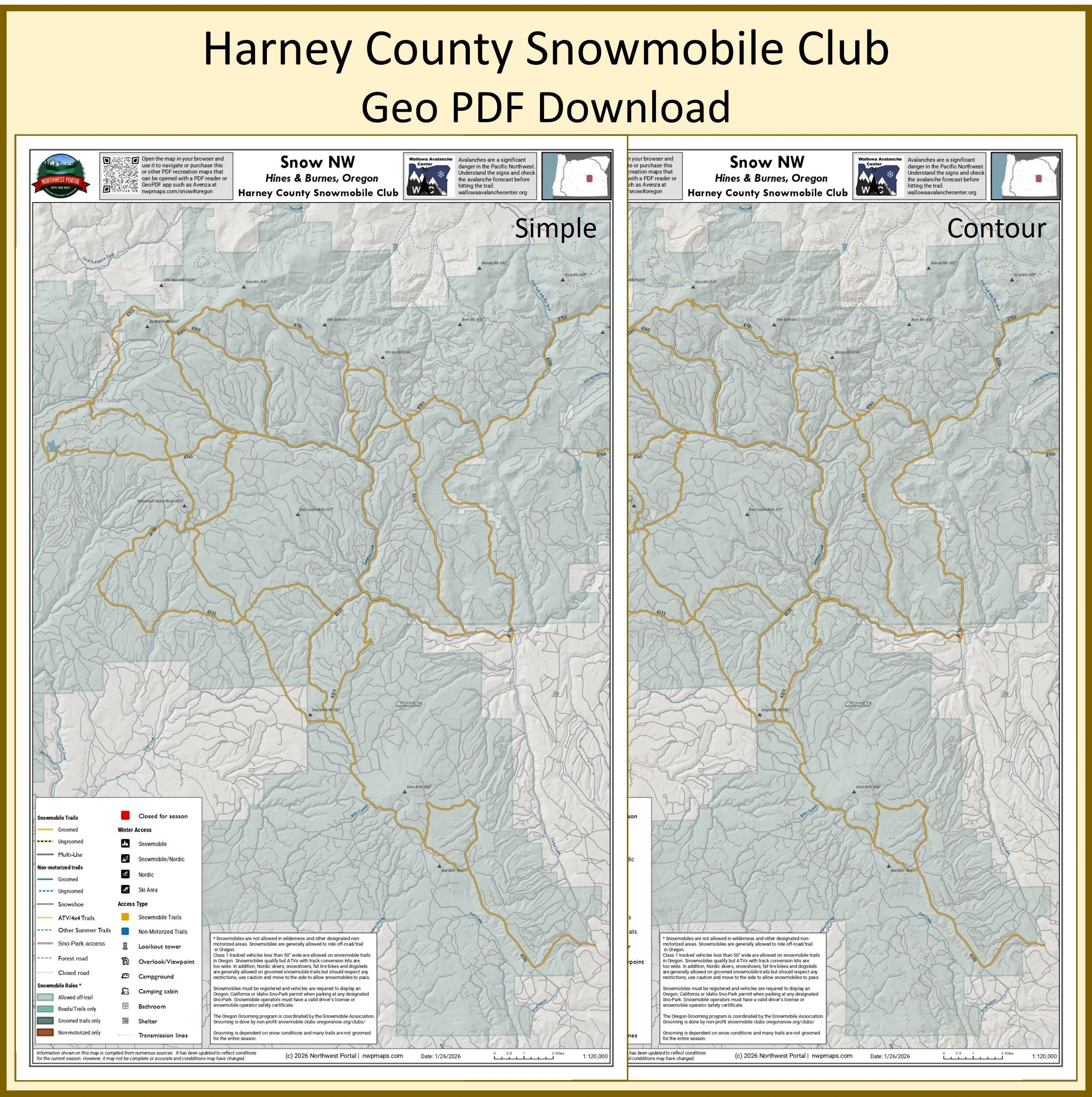
This map of winter trails in Oregon's Malheur National Forest that are groomed by the Harney County Snowmobile Club is part of a series of winter recreation map that show where you can ride your sled, ski or snowshoe in the Pacific Northwest. See which trails are groomed, what areas snowmobiles are allowed and where they are restricted. The maps, which were updated for the 2025-2026 season, include shelters, campgrounds, viewpoints, fire towers as well as summer trails and recreation roads, that are often utilized for winter recreation. It includes trails in Harney County. The map is a tabloid sized (11x17”) PDF at a 1:120,000 scale that you can print or use with a GeoPDF app such as Avenza. You will receive two versions of the map, one with contour lines and one without.
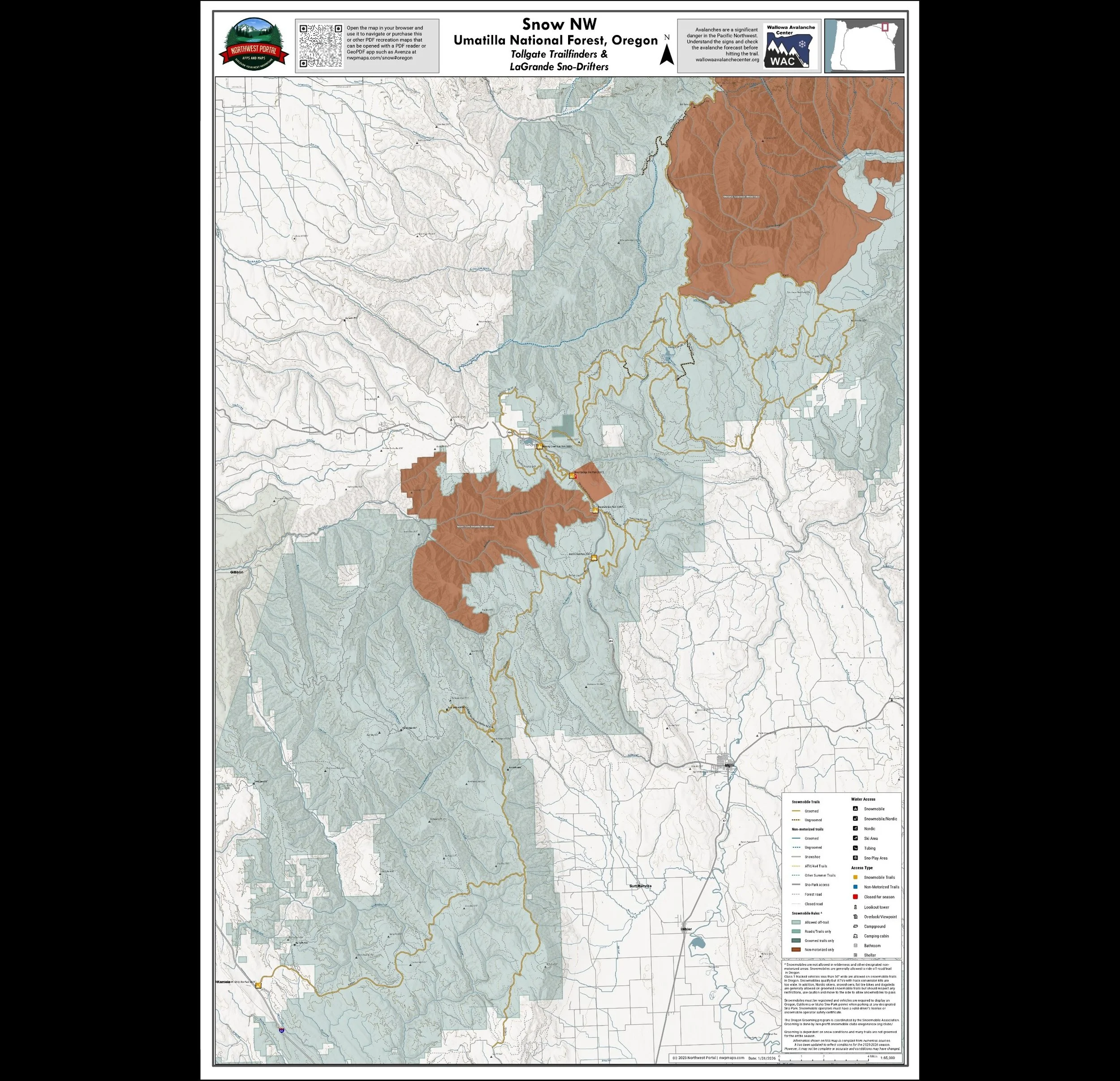
This map shows winter trails in Oregon’s Blue Mountains that are groomed by the Tollgate Trailfinders snowmobile clubs. It is part of a series of winter recreation map that show where you can ride your sled, ski or snowshoe in the Pacific Northwest. See which trails are groomed, what areas snowmobiles are allowed and where they are restricted. The maps, which were updated for the 2025-2026 season, include shelters, campgrounds, viewpoints, fire towers as well as summer trails and recreation roads, that are often utilized for winter recreation. This map shows trails served by Morning Creek, Spout Springs, Woodland, and Andie's Sno-Parks. The map includes areas in Umatilla national Forest in Wallowa and Union County. It is a poster sized (24x36”) PDF at a 1:85,000 scale that you can print or use with a GeoPDF app such as Avenza.
More maps coming soon
Check back for poster sized maps of Oregon
Support Snow NW
Get maps of your riding area and events
And Keep It Free For Users
The Snow NW maps is a public service of Northwest Portal. We need your support to keep them available for users. Join one of our supporting clubs and let them know you saw it on Northwest Portal or encourage your club to becoming a supporting member. Tell your friends about the web maps and GeoPDFs.
Clubs can become supporters for just $100 - and get a tabloid GeoPDF of their riding area with their club logo that they can share with their membesr, plus links to the club page from web maps and one map of a club event/year.

Help people connect to your club and get maps for your club members.
Link to club from the pop-up from up to 10 locations selected by the club,
Tabloid sized GeoPDF of the club riding area with the club logo.
50% discount code for other GeoPDF maps.
Custom maps of club rides, including printable maps and adding ride route to the web map.
Club location on the map if there is an address to be mapped.
Northwest Portal’s Snow NW Blog Posts


Sponsors
The Snow NW App is entirely free to users - thanks to these supporting Sponsors, Clubs, and Advertisers

Participating Communities
Lake Chelan Chamber of Commerce
Participating Clubs
Cascade Drift Skippers, Sno-Jammers, North Central ATV Club, Junco Snowmoible Club, Klamath Basin Snowdrifters, Chiloquin Ridge Riders
Participating Businesses
Using the Map
Snow NW Legend


Snow NW Filters
Filters let you find the perfect destination by highlighting places that meet all of your conditions.
Filters are organized in groups to make them easier to find, but you can select from more than one group. Most groups highlight places that meet all of the conditions, but a few (Land Manager, Pass, and Days Open) let you see places that have any of the options you select.
On the app, use the Filter button in the upper right to open the filter menu; on the web map, use the Filter button to access the filter groups. Once you are done, use Clear (on the web map) or Reset (on the app).
Other Map Functions
Plot your location with your phone GPS.
Use the search function to highlight places by name. Hints: You can also search by the name of the water body and use search to highlight places written up in Northwest Portal Blogs and partner blogs. If you want to use search to find a city and only want to highlight the city, add “City of” to the search name (City of Ellensburg will give you just the city, Ellensburg will give you the city and any places with Ellensburg in the name).
Use the maps even when offline: On the apps, you can download regions for offline navigation. Hint: Make sure to update your downloads regularly to get the latest updates. Once you have downloaded a region, you will not see changes until you update. (Ending 12/31/2025).
Use Avenza maps to navigate off-line.
You can share the web maps with filters or search applied. You can also embed the maps on a page, with a specific location highlighted.
If you dream of riding through a winter wonderland in Washington’s Cascade mountains or want to trying snowmobiling before you invest in the equipment, treat yourself to a guided snowmobile tour or, if you have some experience, rent a snowmobile and explore on your own. Snowmobile Winthrop and Motor Toys Rental and Tours in Cle Elum will help you get out on the snow.